Lab- Mapping Earthquakes and Volcanoes
advertisement
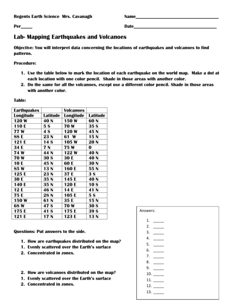
Regents Earth Science Mrs. Cavanagh Name____________________________________ Per_____ Date____________________________________ Lab- Mapping Earthquakes and Volcanoes Objective: You will interpret data concerning the locations of earthquakes and volcanoes to find patterns. Procedure: 1. Use the table below to mark the location of each earthquake on the world map. Make a dot at each location with one color pencil. Shade in those areas with another color. 2. Do the same for all the volcanoes, except use a different color pencil. Shade in those areas with another color. Table: Earthquakes Longitude 120 W 110 E 77 W 88 E 121 E 34 E 74 W 70 W 10 E 85 W 125 E 30 E 140 E 12 E 75 E 150 W 68 W 175 E 121 E Volcanoes Latitude Longitude 40 N 150 W 5S 70 W 4S 120 W 23 N 61 W 14 S 105 W 7N 75 W 44 N 122 W 30 S 30 E 45 N 60 E 13 N 160 E 23 N 37 E 35 N 145 E 35 N 120 E 46 N 14 E 28 N 105 E 61 N 35 E 47 S 70 W 41 S 175 E 17 N 123 E Latitude 60 N 35 S 45 N 15 N 20 N 0 40 N 40 N 30 N 55 N 3S 40 N 10 S 41 N 5S 15 N 30 S 39 S 13 N Questions: Put answers to the side. 1. How are earthquakes distributed on the map? 1. Evenly scattered over the Earth’s surface 2. Concentrated in zones. 2. How are volcanoes distributed on the map? 1. Evenly scattered over the Earth’s surface 2. Concentrated in zones. Answers: 1. 2. 3. 4. 5. 6. 7. 8. 9. 10. 11. 12. 13. _____ _____ _____ _____ _____ _____ _____ _____ _____ _____ _____ _____ _____ 3. 1. 2. 3. 4. What is the relationship between earthquakes and volcanoes? They are located in different places all over the world. They are in separate places. Earthquakes and volcanoes occur in basically the same places. There is no relationship between earthquakes and volcanoes. 4. 1. 2. 3. 4. What area of the US has the greatest risk of earthquake damage? The northeast The southeast The mid-Atlantic The west 5. 1. 2. 3. 4. Which best describes a major characteristic of both volcanoes and earthquakes? They are centered at the poles. They are located in the same geographic areas. They are related to the formation of glaciers. They are restricted to the Southern Hemisphere. 6. 1. 2. 3. 4. Where are earthquakes most likely to take place? (1) along the core-mantle interface (2) where the composition of the Earth tends to be uniform (3) near the Earth's Equator (4) near a fault zone 7. Crustal disturbances such as earthquakes and volcanic eruptions are best described as (1) events that are cyclic and predictable (2) events that are usually related and cannot be predicted with accuracy (3) unrelated events that follow no pattern (4) phenomena seldom found in the same regions Base your answers to questions 8 through 11 on the map below. The map shows crustal plate boundaries located along the Pacific coastline of the United States. The arrows show the general directions in which some of the plates appear to be moving slowly. 8. Which feature is located at 20º North latitude and 109º West longitude? (1) San Andreas fault (3) Baja California (2) East Pacific rise (4) Juan de Fuca Ridge 9. Geologic studies of the San Andreas fault indicate that (1) many earthquakes occur along the San Andreas fault (2) the North American plate and the Pacific plate are locked in dynamic equilibrium (3) the subduction zone is the boundary at which the crustal plates are drifting apart (4) the age of the bedrock increases as distance from the fault increases 10. Which features are most often found at crustal plate boundaries like those shown on the map? (1) meandering rivers and warm-water lakes (2) plains and plateaus (3) geysers and glaciers (4) faulted bedrock and volcanoes Base your answer to question 11 on the Earth Science Reference Tables and the map below. The map shows mid-ocean ridges and trenches in the Pacific Ocean. Specific areas A, B, C, and D are indicated by shaded rectangles. 11. Movement of the crustal plates shown in the diagram ismost likely caused by (1) the revolution of the Earth (2) the erosion of the Earth's crust (3) shifting of the Earth's magnetic poles (4) convection currents in the Earth's mantle
