jec12325-sup-0001-FigS1-TabS1-S5
advertisement
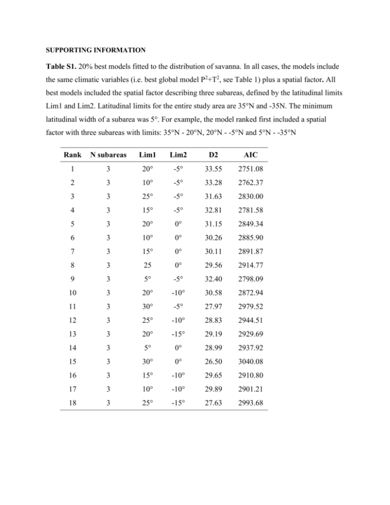
SUPPORTING INFORMATION Table S1. 20% best models fitted to the distribution of savanna. In all cases, the models include the same climatic variables (i.e. best global model P2+T2, see Table 1) plus a spatial factor. All best models included the spatial factor describing three subareas, defined by the latitudinal limits Lim1 and Lim2. Latitudinal limits for the entire study area are 35°N and -35N. The minimum latitudinal width of a subarea was 5°. For example, the model ranked first included a spatial factor with three subareas with limits: 35°N - 20°N, 20°N - -5°N and 5°N - -35°N Rank N subareas Lim1 Lim2 D2 AIC 1 3 20° -5° 33.55 2751.08 2 3 10° -5° 33.28 2762.37 3 3 25° -5° 31.63 2830.00 4 3 15° -5° 32.81 2781.58 5 3 20° 0° 31.15 2849.34 6 3 10° 0° 30.26 2885.90 7 3 15° 0° 30.11 2891.87 8 3 25 0° 29.56 2914.77 9 3 5° -5° 32.40 2798.09 10 3 20° -10° 30.58 2872.94 11 3 30° -5° 27.97 2979.52 12 3 25° -10° 28.83 2944.51 13 3 20° -15° 29.19 2929.69 14 3 5° 0° 28.99 2937.92 15 3 30° 0° 26.50 3040.08 16 3 15° -10° 29.65 2910.80 17 3 10° -10° 29.89 2901.21 18 3 25° -15° 27.63 2993.68 Table S2. List of the 17 Coupled Model Intercomparison Project Phase 5 (CMIP5) general circulation models used in this study Model Name Institution ID Modeling Center ACCESS1-0 CSIRO-BOM Commonwealth Scientific and Industrial Research Organization (CSIRO) and Bureau of Meteorology (BOM), Australia BCC-CSM1-1 BCC Beijing Climate Center, China Meteorological Administration CCSM4 NCAR National Center for Atmospheric Research CNRM-CM5 CNRM - CERFACS Centre National de Recherches Météorologiques / Centre Européen de Recherche et Formation Avancée en Calcul Scientifique GFDL-CM3 NOAA GFDL NOAA Geophysical Fluid Dynamics Laboratory GISS-E2-R NASA GISS NASA Goddard Institute for Space Studies HadGEM2-AO NIMR/KMA National Institute of Meteorological Research/Korea Meteorological Administration HadGEM2-CC MOHC (additional realizations by INPE) Met Office Hadley Centre (additional HadGEM2-ES realizations contributed by Instituto Nacional de Pesquisas Espaciais) HadGEM2-ES MOHC (additional realizations by INPE) Met Office Hadley Centre (additional HadGEM2-ES realizations contributed by Instituto Nacional de Pesquisas Espaciais) INM-CM4 INM Institute for Numerical Mathematics IPSL-CM5A-LR IPSL Institut Pierre-Simon Laplace MIROC-ESM-CHEM MIROC Japan Agency for Marine-Earth Science and Technology, Atmosphere and Ocean Research Institute (The University of Tokyo), and National Institute for Environmental Studies MIROC-ESM MIROC Japan Agency for Marine-Earth Science and Technology, Atmosphere and Ocean Research Institute (The University of Tokyo), and National Institute for Environmental Studies MIROC5 MIROC Atmosphere and Ocean Research Institute (The University of Tokyo), National Institute for Environmental Studies, and Japan Agency for Marine-Earth Science and Technology MPI-ESM-LR MPI-M Max-Planck-Institut für Meteorologie (Max Planck Institute for Meteorology) MRI-CGCM3 MRI Meteorological Research Institute NorESM1-M NCC Norwegian Climate Centre Table S3. Predicted extent of forest, savanna and treeless areas in the tropical and subtropical Americas for 2070 under the RCP8.5 scenario for the 17 downscaled and calibrated CMIP5 global climate models (GCM). Area in 103 km2. See description of climatic models in Table S2 GCM ACCESS1-0 BCC-CSM1-1 CCSM4 CNRM-CM5 GFDL-CM3 GISS-E2-R HadGEM2-AO HadGEM2-CC HadGEM2-ES INM-CM4 IPSL-CM5A-LR MIROC-ESM-CHEM MIROC-ESM MIROC5 MPI-ESM-LR MRI-CGCM3 NorESM1-M Forest 4562 4942 4735 4886 3091 4544 4011 3882 4127 6107 5668 5493 6397 5057 3355 5306 4767 % Forest 21 23 22 22 14 21 18 18 19 28 26 25 29 23 15 24 22 Savanna 14568 14108 14343 14384 15707 14313 15292 15289 14980 12848 13010 13551 12632 13949 15569 13928 14001 %Savanna 67 65 66 66 72 66 70 70 69 59 60 62 58 64 71 64 64 Treeless 2717 2797 2769 2577 3049 2990 2543 2676 2740 2891 3168 2803 2818 2841 2923 2613 3079 % Treeless 12 13 13 12 14 14 12 12 13 13 15 13 13 13 13 12 14 Table S4. Predicted extent of the classes of the Forest-savanna transition index in the tropical and subtropical Americas for 2070 under the RCP8.5 scenario for the 17 downscaled and calibrated CMIP5 global climate models (GCM). This index is calculated as p(forest) – p(savanna). Values closer to 1 indicates cells with low uncertainty of being savanna, values closer to -1 indicates cells with low uncertainty of being forest and values closer to 0 indicates high uncertainty. Mean values are shown in Figure 6 (top). See description of climatic models in Table S2. Area in 103 km2 GCM (.5,1] (.5,.4] (.4,.3] (.3,.2] (.2,.1] (.1,-.1] (-.1,.2] (-.2,.3] (-.3,.4] (-.4,.5] (-.5,-1] ACCESS1-0 BCC-CSM1-1 6965 993 876 690 650 1288 663 657 716 721 1146 6025 1000 962 840 678 1427 763 754 744 650 1286 CCSM4 6285 849 800 721 637 1388 661 709 620 737 1307 CNRM-CM5 6378 965 975 883 776 1598 773 681 643 797 1218 GFDL-CM3 6992 893 835 936 935 1928 760 616 291 157 331 GISS-E2-R 6890 883 854 729 635 1088 534 631 720 797 1347 HadGEM2-AO 7555 982 648 540 577 1171 554 540 623 707 997 HadGEM2-CC 7303 1099 795 653 666 1204 631 696 684 606 687 HadGEM2-ES 7364 1064 831 668 559 1239 680 689 673 739 717 INM-CM4 5940 771 651 538 488 1048 674 704 797 949 2440 IPSL-CM5A-LR 6514 689 532 540 551 1331 872 689 834 1111 1467 MIROC-ESM-CHEM 6252 933 766 629 609 1362 690 718 619 750 2014 MIROC-ESM 5423 880 759 725 723 1400 850 945 1065 1075 1744 MIROC5 6242 712 673 632 722 1401 821 822 744 697 1278 MPI-ESM-LR 7536 1288 1022 748 650 1121 579 531 459 582 643 MRI-CGCM3 6542 647 642 652 627 1366 807 906 816 726 1289 NorESM1-M 6191 859 801 680 646 1211 600 597 665 622 1692 Table S5. Predicted extent of the classes of the Savanna-Treeless transition index in the tropical and subtropical Americas for 2070 under the RCP8.5 scenario for the 17 downscaled and calibrated CMIP5 global climate models (GCM). This index is calculated as p(savanna) – p(treeless).Values closer to 1 indicates cells with low uncertainty of being treeless, values closer to -1 indicates cells with low uncertainty of being savanna and values closer to 0 indicates high uncertainty. Mean values are shown in Figure 6 (bottom). See description of climatic models in Table S2. Area in 103 km2 GCM (.5,1] (.5,.4] (.4,.3] (.3,.2] (.2,.1] (.1,.1] (-.1,.2] (-.2,.3] (-.3,.4] (-.4,.5] (-.5,1] ACCESS1-0 BCC-CSM1-1 CCSM4 CNRM-CM5 GFDL-CM3 GISS-E2-R HadGEM2-AO HadGEM2-CC HadGEM2-ES INM-CM4 IPSL-CM5A-LR MIROC-ESMCHEM MIROC-ESM MIROC5 MPI-ESM-LR MRI-CGCM3 NorESM1-M 1694 217 225 205 198 350 197 248 276 354 2573 1628 278 248 218 205 491 275 293 325 389 2440 1537 257 226 234 262 539 273 291 348 444 2788 1483 268 230 218 203 362 206 255 292 347 2348 1746 309 235 250 240 587 349 354 374 419 2369 1856 254 207 207 226 497 233 230 276 333 2474 1495 238 213 196 192 446 268 301 356 430 2878 1547 269 240 240 203 381 242 278 345 405 2740 1692 258 246 214 171 336 205 253 273 396 2648 1737 269 218 218 233 471 276 297 355 448 2373 1990 290 260 236 206 402 221 251 326 375 2223 1791 245 220 206 184 357 223 248 300 348 2453 1777 256 219 205 185 378 227 254 317 381 2130 1586 293 251 251 232 529 330 354 413 521 2404 1846 262 220 197 211 366 185 250 369 411 2445 1475 211 222 255 235 468 289 356 407 531 2432 1856 272 227 231 257 485 243 293 324 435 2738 Fig S1. Distribution of areas undergoing human activities (categories 16-18 and 22 in the Global Land Cover 2000 (GLC2000; Bartholome & Belward, 2005) in the Tropical and Subtropical Americas (dark grey). These areas were filtered out from our analyses.
