Weekly Report 08 April 2015 - Murray
advertisement
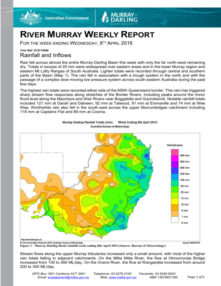
RIVER MURRAY WEEKLY REPORT FOR THE WEEK ENDING WEDNESDAY, 8TH APRIL 2016 Trim Ref: D15/13998 Rainfall and Inflows Rain fell across almost the entire Murray-Darling Basin this week with only the far north-west remaining dry. Totals in excess of 25 mm were widespread over eastern areas and in the lower Murray region and eastern Mt Lofty Ranges of South Australia. Lighter totals were recorded through central and southern parts of the Basin (Map 1). The rain fell in association with a trough system in the north and with the passage of a complex slow moving low pressure system across south-eastern Australia during the past few days. The highest rain totals were recorded either side of the NSW-Queensland border. This rain has triggered sharp stream flow responses along stretches of the Border Rivers, including peaks around the minor flood level along the Macintyre and Weir Rivers near Boggabilla and Goondiwindi. Notable rainfall totals included 121 mm at Garah and Dalveen, 92 mm at Talwood, 91 mm at Emmaville and 74 mm at Wee Waa. Worthwhile rain also fell in the south-east across the upper Murrumbidgee catchment including 118 mm at Captains Flat and 89 mm at Cooma. Figure 1 - Murray Darling Basin rainfall week ending 8th April 2015 (Source: Bureau of Meteorology) Stream flows along the upper Murray tributaries increased only a small amount, with most of the higher rain totals falling in adjacent catchments. On the Mitta Mitta River, the flow at Hinnomunjie Bridge increased from 130 to 260 ML/day. On the Ovens River, the flow at Wangaratta increased from around 200 to 300 ML/day. GPO Box 1801 Canberra ACT 2601 Email: engagement@mdba.gov.au Telephone: 02 6279 0100 Facsimile: 02 6248 8053 Web: www.mdba.gov.au ABN 13679821382 Page 1 of 6 River Operations Hume storage volume to fall to 20% next week Lock 8 to be lowered to 80cm below full supply level MDBA total storage fell by 103 GL this week, with the active storage now 3,587 GL (43% capacity). Although rainfall has temporarily reduced demands and losses across the system, flows downstream of Yarrawonga continue at close to channel capacity. One of the large downstream demands is the requirement of the Murray-Darling Basin Agreement to provide 350 GL in Lake Victoria by the end of May. Releases downstream of Yarrawonga will remain high in order to meet this target, along with other demands, unless there are further rainfall events which assist. Dartmouth Reservoir storage decreased by 24 GL to 2,971 GL (77% capacity). The release from Dartmouth, measured at the Colemans gauge, is currently 6,000 ML/day aimed at transferring water to Hume and will continue at this flow rate over the coming week. At Hume Reservoir the storage fell by 65 GL to 644 GL (21% capacity), see photo below. Hume storage volume is expected to fall to 20% over the coming week. Releases at the start of the week were 18,500 ML/day but were gradually reduced to 13,500 ML/day in response to the forecast rainfall. Reducing releases in anticipation of rain and the possibility of a “rain rejection” event (a marked reduction in irrigation demands at the major irrigation offtakes) reduced the risk of unseasonal flooding of Barmah-Millewa forest as well as helped maintain consistent levels in Lake Mulwala over Easter. Photo 1 – Hume Reservoir storage level at 22% over the Easter weekend (source Sean Kelly). At Yarrawonga Weir, the total diversion through the major irrigation offtakes reduced on the back of rain and mild temperatures. The MDBA order through the Mulwala Canal at the Edward escape was reduced by 400 ML/day last week and subsequently increased again to assist in managing the weir pool level. The release downstream of Yarrawonga Weir continued at close to 10,000 ML/day. The GPO Box 1801 Canberra ACT 2601 Email: engagement@mdba.gov.au Telephone: 02 6279 0100 Web: www.mdba.gov.au Facsimile: 02 6248 8053 ABN 13679821382 Page 2 of 6 MDBA continues to run water through the Mulwala Canal (with releases at Edward, Wakool and Perricoota escapes) and through Yarrawonga Main Channel. On the Goulburn River, flows at McCoys Bridge have receded throughout the week and are forecast to average around 950 ML/day. The flow above the minimum of 350 ML/day at this time is environmental water aimed at providing a base flow in the Goulburn River and is expected to continue for much of autumn. Downstream at Torrumbarry Weir, diversions at National Channel have decreased from around 3,000 to 2,200 ML/day and the downstream flow is currently about 6,600 ML/day. On the lower Murrumbidgee River, Inter Valley Transfer (IVT) water continues to be delivered at Balranald with a target of 900 ML/day. The Euston Weir pool level will recommence lowering after it was raised temporarily last week to assist a number of boats that were stranded on the ‘cut’ – a natural elevated cutting through a bend in the Murray that is normally inundated by the weir pool. Euston weir pool will continue to fall this week until a target of 25cm below full supply level (FSL) is reached. The lowering will provide additional flows in the Murray to meet downstream demands. The weir pool is likely to remain lowered for some time, unless there is sufficient future rain in the mid-Murray. At Lock 8, the weir pool level will be gradually lowered a further 20 cm to 80 cm below FSL this week as part of the current weir pool manipulation trial. The aim of the trial is to increase the variability of water levels, fundamental for the health of riverine ecosystems, whilst still meeting the needs of irrigation, navigation and recreation at the weir. The benefits from weir pool variability include improvements for riparian vegetation, reduced stress on floodplain vegetation and improvement to biofilms which are important components of the riverine food chain supporting aquatic invertebrates. Lowering the weir pool level also increases the amount of flowing water habitat (that would otherwise be ‘slack water’ at the upstream end of the weir pool) which is important for fish and other biota. In weir pools, recruitment of many of the large bodied native fish such as Murray Cod, Golden Perch and Silver Perch are dependent on flowing water habitats. At Menindee Lakes, the storage decreased by 7 GL and is now at 78 GL (5% capacity). Releases at Weir 32 averaged 350 ML/day this week. At Lake Victoria, essential maintenance works on the outlet structure are continuing. The storage volume decreased this week to 166 GL (25% capacity) and the flow to South Australia is currently 6,000 ML/day, with a target of 6,400 ML/day for the next few days. At the Lower Lakes, the 5-day average level in Lake Alexandrina is 0.51 m AHD. Releases through the Barrages have averaged around 500 ML/day over the last week because of high tides and swell. For media inquiries contact the Media Officer on 02 6279 0141 DAVID DREVERMAN Executive Director, River Management GPO Box 1801 Canberra ACT 2601 Email: engagement@mdba.gov.au Telephone: 02 6279 0100 Web: www.mdba.gov.au Facsimile: 02 6248 8053 ABN 13679821382 Page 3 of 6 Water in Storage Week ending Wednesday 08 Apr 2015 Full Supply Level MDBA Storages Dartmouth Reservoir Hume Reservoir Lake Victoria Menindee Lakes Total Total Active MDBA Storage Current Storage Level Full Supply Volume (m AHD) 486.00 192.00 27.00 (GL) 3 856 3 005 677 1 731* 9 269 Major State Storages Burrinjuck Reservoir Blowering Reservoir Eildon Reservoir Current Storage (GL) 2 971 644 166 78 3 859 % 77% 21% 25% 5% 42% 334 452 1 927 33% 28% 58% (m AHD) 471.41 175.20 22.11 1 026 1 631 3 334 Dead Storage Active Storage (GL) 71 23 100 (- -) # -- (GL) 2 900 621 66 0 3 587 43% ^ 3 24 100 331 428 1 827 Change in Total Storage for the Week (GL) -24 -65 -7 -7 -103 +1 -8 -42 * Menindee surcharge capacity – 2050 GL ** All Data is rounded to nearest GL ** # NSW takes control of Menindee Lakes when storage falls below 480 GL, and control reverts to MDBA when storage next reaches 640 GL ^ % of total active MDBA storage Snowy Mountains Scheme Storage Lake Eucumbene - Total Snowy-Murray Component Target Storage Snowy diversions for week ending 07 Apr 2015 Active Storage (GL) 2 177 989 1 340 Weekly Change (GL) n/a n/a Diversion (GL) From 1 May 2014 384 214 170 658 This Week Snowy-Murray Tooma-Tumut Net Diversion Murray 1 Release +12 +1 12 +11 Major Diversions from Murray and Lower Darling (GL) * New South Wales This Week Murray Irrig. Ltd (Net) Wakool Sys Allowance Western Murray Irrigation Licensed Pumps Lower Darling TOTAL 22.2 2.9 0.2 7.0 0.1 32.4 From 1 July 2014 811 71 23 255 60 1220 Victoria This Week Yarrawonga Main Channel (net) Torrumbarry System + Nyah (net) Sunraysia Pumped Districts Licensed pumps - GMW (Nyah+u/s) Licensed pumps - LMW TOTAL 9.2 16.8 1.2 1.9 2 31.1 From 1 July 2014 280 572 102 60 266 1280 * Figures derived from estimates and monthly data. Please note that not all data may have been available at the time of creating this report. ** All data above is rounded to nearest 100 ML for weekly data and nearest GL for cumulative data** Flow to South Australia (GL) * Flow to SA will be greater than normal entitlement for this month due to the delivery of additional environmental water. Salinity (EC) Entitlement this month Flow this week Flow so far this month Flow last month 135.0 * 45.1 50.9 249.0 (6 400 ML/day) (microSiemens/cm at 25o C) Current Swan Hill Euston Red Cliffs Merbein Burtundy (Darling) Lock 9 Lake Victoria Berri Waikerie Morgan Mannum Murray Bridge Milang (Lake Alex.) Poltalloch (Lake Alex.) Meningie (Lake Alb.) Goolwa Barrages Average over the last week 70 90 110 110 890 120 240 240 300 280 290 300 800 730 2 430 3 340 GPO Box 1801 Canberra ACT 2601 Email: engagement@mdba.gov.au Average since 1 August 2014 80 80 110 110 890 120 230 240 290 270 290 300 810 670 2 520 2 630 Telephone: 02 6279 0100 Web: www.mdba.gov.au 90 100 120 130 800 130 210 220 280 280 330 360 780 620 2 420 1 280 Facsimile: 02 6248 8053 ABN 13679821382 Page 4 of 6 River Levels and Flows Week ending Wednesday 08 Apr 2015 7.3 - 1.49 2.69 3.07 2.89 1.93 3.11 1.63 2.27 2.18 1.24 2.99 1.67 2.99 3.27 0.63 208.01 219.58 156.70 151.36 149.37 129.13 116.67 106.11 80.73 64.16 52.11 43.51 27.75 20.20 - (ML/day) 3 000 2 900 5 390 13 140 13 470 15 000 9 890 10 200 6 280 6 340 7 820 8 640 8 340 8 590 5 160 4 720 F R R F F F S R S R R F F R F R (ML/day) 1 480 2 620 3 790 15 600 15 810 16 460 9 890 10 110 6 310 5 960 7 890 8 700 7 770 7 900 5 560 4 260 Average Flow last Week (ML/day) 4 630 4 610 3 440 17 530 17 900 17 700 9 910 10 040 6 780 6 630 7 790 7 120 5 970 6 130 5 260 4 340 2.8 11.9 9.0 5.5 5.0 6.1 9.0 - 0.71 7.83 1.59 2.30 2.71 1.42 1.56 3.44 3.93 - 153.94 145.51 93.01 82.07 58.09 54.91 57.52 - 180 290 1 120 2 460 2 160 410 1 160 620 10 10 R R F F S S R R S R 170 220 1 440 2 090 2 190 390 1 260 190 10 0 160 200 2 480 2 320 2 180 270 1 080 30 30 0 220 250 Minor Flood Stage River Murray Khancoban Jingellic Tallandoon ( Mitta Mitta River ) Heywoods Doctors Point Albury Corowa Yarrawonga Weir (d/s) Tocumwal Torrumbarry Weir (d/s) Swan Hill Wakool Junction Euston Weir (d/s) Mildura Weir (d/s) Wentworth Weir (d/s) Rufus Junction Blanchetown (Lock 1 d/s) (m) Tributaries Kiewa at Bandiana Ovens at Wangaratta Goulburn at McCoys Bridge Edward at Stevens Weir (d/s) Edward at Liewah Wakool at Stoney Crossing Murrumbidgee at Balranald Barwon at Mungindi Darling at Bourke Darling at Burtundy Rocks Gauge local (m) 4.0 4.2 5.5 5.5 4.3 4.6 6.4 6.4 7.3 4.5 8.8 9.1 Height (m AHD) Flow Trend Average Flow this Week Natural Inflow to Hume (i.e. Pre Dartmouth & Snowy Mountains scheme) Weirs and Locks Pool levels above or below Full Supply Level (FSL) Murray Yarrawonga No. 26 Torrumbarry No. 15 Euston No. 11 Mildura No. 10 Wentworth No. 9 Kulnine No. 8 Wangumma Lower Lakes FSL (m AHD) 124.90 86.05 47.60 34.40 30.80 27.40 24.60 u/s -0.07 +0.00 -0.08 +0.07 +0.10 -0.01 -0.69 d/s +0.28 +0.35 -0.60 +0.22 FSL (m AHD) 22.10 19.25 16.30 13.20 9.80 6.10 3.20 No. 7 Rufus River No. 6 Murtho No. 5 Renmark No. 4 Bookpurnong No. 3 Overland Corner No. 2 Waikerie No. 1 Blanchetown u/s +0.06 +0.02 +0.05 +0.09 +0.04 +0.05 -0.07 d/s +0.95 +0.09 +0.24 +0.76 +0.20 +0.08 -0.12 FSL = 0.75 m AHD Lake Alexandrina average level for the past 5 days (m AHD) Barrages 0.51 Fishways at Barrages Openings Level (m AHD) No. Open Goolwa 128 openings 0.55 All closed Mundoo 26 openings 0.51 All closed Boundary Creek 6 openings 0.1 Ewe Island 111 gates All closed Tauwitchere 322 gates 0.56 All closed AHD = Level relative to Australian Height Datum, i.e. height above sea level GPO Box 1801 Canberra ACT 2601 Email: engagement@mdba.gov.au Rock Ramp Telephone: 02 6279 0100 Web: www.mdba.gov.au Open Vertical Slot Open Open Facsimile: 02 6248 8053 ABN 13679821382 Page 5 of 6 Week ending Wednesday 08 Apr 2015 State Allocations (as at 08 Apr 2015) NSW - Murray Valley High security General security Victorian - Murray Valley 97% 61% NSW – Murrumbidgee Valley High security General security 95% 51% 100% 0% Victorian - Goulburn Valley High reliability Low reliability 100% 0% South Australia – Murray Valley NSW - Lower Darling High security General security High reliability Low reliability 100% 100% High security 100% NSW : http://www.water.nsw.gov.au/Water-management/Water-availability/Waterallocations/Water-allocations-summary/water-allocations-summary/default.aspx VIC : SA : http://www.nvrm.net.au/allocations/current.aspx http://www.environment.sa.gov.au/managing-natural-resources/river-murray GPO Box 1801 Canberra ACT 2601 Email: engagement@mdba.gov.au Telephone: 02 6279 0100 Facsimile: 02 6248 8053 Web: www.mdba.gov.au ABN 13679821382 Page 6 of 6
