Mr. Trzepinska World Cultures Geography of India As you move from
advertisement
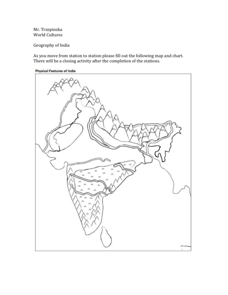
Mr. Trzepinska World Cultures Geography of India As you move from station to station please fill out the following map and chart. There will be a closing activity after the completion of the stations. Step 2: Working with your group complete the following chart. Write a brief description of each physical feature. Then, in each box, rate the feature on a scale of 1 to 5 (1 = Unsuitable for settlement, 5 = Very suitable for settlement) Section 2 – Brahmaputra River The land of India is a subcontinent of Asia. Looking at a map of Asia, you can see that India is attached to this continent. Many geographers call this part of Asia the Indian subcontinent. It is a large, triangular landmass that juts out from the southern part of Asia. Mountain ranges separate much of the Indian subcontinent from the rest of Asia. Our exploration of India begins with the Brahmaputra (brah-muh-POO-truh) River. This river runs through the steep Himalayas, the mountains along the northern border of India. From there, the Brahmaputra winds through snowcapped mountains and narrow canyons. The water is clear and cold as it rushes over the sharp rocks. The river becomes slower and deeper as it flows into its valley. Every summer, this part of the river receives added water from heavy monsoon rains. A monsoon is a strong wind that often brings huge amounts of rain. These rains can cause the river to overflow its banks. As the river recedes, the rich minerals that have been carried down from the Himalayas remain in the soil of the valley. Eventually, the Brahmaputra River joins another river, the Ganges (GAN-jeez), on the plains. The land where the two rivers meet is very fertile. Section 3 – Deccan Plateau The Deccan (DEH-kuhn) Plateau is a triangle-shaped area that lies between two mountain ranges in southern India. A plateau is an elevated, or raised, area of land that is flatter than a mountain. The Deccan Plateau has several kinds of land. In the flatter parts, large granite rocks formed by volcanoes cover the land. These rocks are among the world’s oldest, dating back more than six hundred million years. The hillier parts of the plateau have thin forests and low, scrubby bushes. The plateau is fairly dry. There are a few rivers, but the monsoon rains provide most of the water. The soil on the plateau is black, yellow, or red. The black soil is rich in iron and good for growing cotton. The yellow and red soils lack key minerals. This makes it harder for farmers to grow plants in those areas. Section 4- Eastern and Western Ghats The Eastern and Western Ghats (gahts) are long mountain chains near the coasts of India. The Eastern Ghats extend along India’s east coast. The Western Ghats extend along the west coast. When seen from above, the Ghats form a large “V.” The Deccan Plateau lies between these two mountain ranges. The Western Ghats are higher than the Eastern Ghats. The Western Ghats have steep slopes; narrow valleys; thick, hardwood forests; and extremely heavy rains. The wet climate encourages the growth of tropical plants. The Eastern Ghats are not as wet as the Western Ghats. Several rivers flow through these green mountains, which are dotted with hardwood trees. The rivers rarely flood, but they are unsafe for travel. They move rapidly, contain many rocks, and often plunge suddenly over cliffs. Section 5 – Ganges River The Ganges River flows across most of northern India. It starts in the Himalaya Mountains. The river makes its way south through ice, rocks, and magnificent mountains and valleys. The river carries silt from the Himalayas to the northern plains. As the river passes through the plains, it leaves the rich sediment behind. As a result, the northern plains contain some of the most fertile farmland in the world. Melted ice carried down from the Himalayas provides the Ganges River plains with a good supply of water. During the rainy season, the river can flood and destroy crops planted along its banks. Section 6 – Himalaya Mountains The Himalaya Mountains are located along India’s northern border. This mountain range is the highest in the world. Mount Everest, the world’s tallest mountain, is part of the Himalayas. It reaches more than five and a half miles into the sky. The Himalayas form a natural border between the Indian subcontinent and most of the rest of Asia. The Himalayas live up to their name, which means “home of snows.” The highest peaks are always covered in snow and ice. Fierce storms can dump 10 feet of snow on the area at one time. Water from glaciers in the Himalaya Mountains feeds northern India’s major rivers. Underneath the Himalaya Mountains, the Earth is always moving. This movement causes Mount Everest to rise slightly every year. It also makes earthquakes and landslides common in the area. Section 7 – Hindu Kush Mountains The Hindu Kush mountains form a rugged barrier between the Indus (IN-duhs) River valley and Afghanistan. This mountain range is not as tall as the Himalayas, but it is still one of the highest in the world. Some of its peaks are almost five miles high. Many parts of the mountain range are unlivable. Snow and ice permanently cover the steep slopes and peaks. The Khyber (KIE-ber) Pass forms a gap about 30 miles long in the mountains on the Afghanistan-Pakistan border. The pass connects central Asia to the Indian subcontinent. For thousands of years, traders used the pass to enter the Indus River valley. Invaders also used the pass. But many died in the mountains’ unforgiving landscape. Section 8 – Indus River The Indus River begins in the Himalaya Mountains. It gets water from snow melting in the Hindu Kush mountains and other mountain ranges. This runoff of melting snow and ice from the mountains keeps the river’s water level high. Eventually, the river flows through present-day Pakistan and empties into the Arabian Sea. The Indus River valley contains some of the best farmland in the world. Like the Ganges River, the Indus River carries silt from the mountains to the plains. The silt leaves the surrounding soil rich and fertile. The Indus River has often been compared to Egypt’s Nile River. Like the Nile, the Indus is an important source of water for the farmland that lies along its banks. Section 9 – Thar Desert The massive Thar (tahr) Desert in northern India is mostly sand and stone. Huge, rolling sand dunes stretch for hundreds of miles. The landscape is littered with rocks. There is very little plant life except for grass and low, hardy shrubs. Most of the time, the heat is unbearable. Water is a very precious resource in the desert. Rain is rare, although the monsoons may occasionally bring a brief but intense storm. The dry conditions make dust storms common. Many animals and birds make their home in the desert. There are more than fortyfive kinds of lizards and snakes. Gazelles lope across the sand. Birds include quail, ducks, and geese.
