ex2_smrhodes_report_..
advertisement
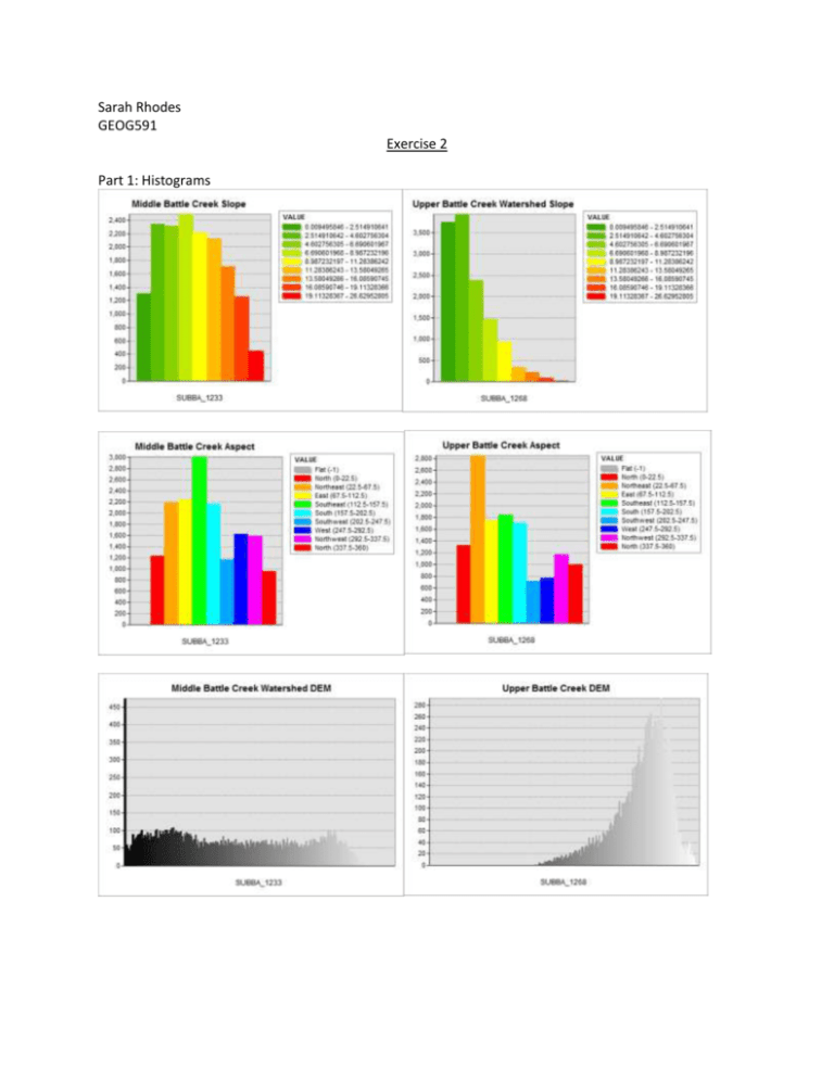
Sarah Rhodes GEOG591 Exercise 2 Part 1: Histograms Q1. Differentiate between terrain characteristics in each of the subwatershed areas based on the DEM and aspect distributions. How are DEM and aspect distributed in each of the two subwatersheds? Based on the histograms above, the Middle Creek sub-watershed is characterized by variations in elevation. This is shown by frequent changes in slope as shown by the slope histogram. The stream network occupies the lower elevation areas. Finally, the Middle Creek sub-watershed primarily faces the Southeast. On the other hand, the Upper sub-watershed is relatively flat (lower slope values and more uniform elevation) and primarily faces the Northeast. Also, the Upper Battle Creek subwatershed has generally higher elevation than Middle Battle Creek (-0.5). Q2. Compare the stream network and flow direction maps between the original and filled DEM. What is the major difference between them? Prior to performing the fill, the stream network does not have connectivity and in areas near pits, the flow directions all flow towards the pit. Post-fill, the streams have connectivity and the flow direction parallels the natural elevation changes and is not affected by the change in elevation that resulted due to the presence of pits. For example, in the northernmost section of the upper sub-watershed, areas that flowed to the east or southeast change and flow south after the pits are filled (red or orange changes to yellow, as shown by the maps.) Q3. Comment on the spatial distribution of depression cells. Where can you find major pits? How does filling pits affect the flow paths of this area? Why? Major pits are found behind large roadways, such as Franklin Street, Cameron Avenue and South Road. Pits form because the D-8 model does not take into account that water can flow under the roads via culverts and therefore, it creates artificial lakes. Filling these regions allows for the flow to be normalized because it allows the water to flow as if there was a section cut out of the roads. Pit location: Around a main stream (Battle Creek) (-1.0) and roads Q4/Q5: How many hectares is the 1000 and the 500 grid cell threshold that defines the stream heads? What range of drainage area (in hectares) appears to define a stream head in this area? Stream Type Fill Pixel Count Flow Accumulation in Hectares >500 601 pixels 2.233 ha >1000 1346 pixels 5.002 ha The range of drainage area that defines a stream heads ranges from approximately 2-3 ha to approximately 5 hectares. I need to see the detailed equation for your results; For stream_500, 601 *400 * 0.000009290304 hectare = 2.233 hectares. For stream_1000, 1346 *400 * 0.000009290304 hectare = 5.002 hectares. (23.5/25)
