Biodiversity Fund Round 2 – Successful Recipients
advertisement
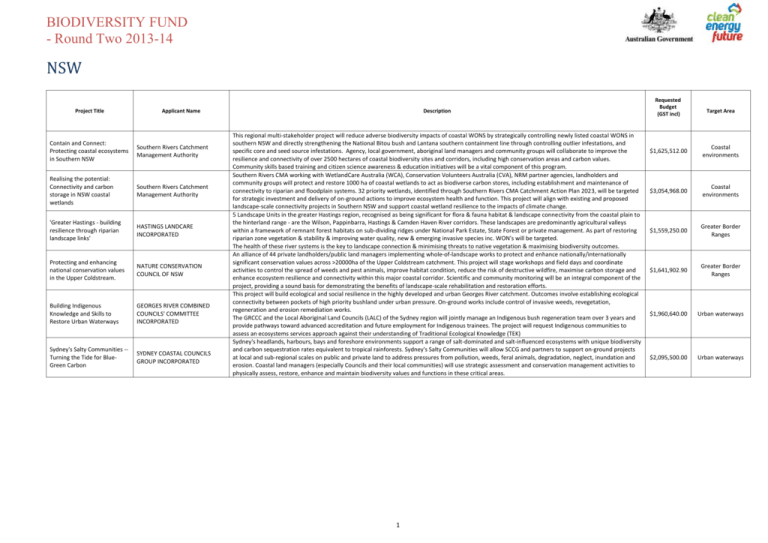
BIODIVERSITY FUND - Round Two 2013-14 NSW Project Title Applicant Name Contain and Connect: Protecting coastal ecosystems in Southern NSW Southern Rivers Catchment Management Authority Realising the potential: Connectivity and carbon storage in NSW coastal wetlands Southern Rivers Catchment Management Authority 'Greater Hastings - building resilience through riparian landscape links' HASTINGS LANDCARE INCORPORATED Protecting and enhancing national conservation values in the Upper Coldstream. NATURE CONSERVATION COUNCIL OF NSW Building Indigenous Knowledge and Skills to Restore Urban Waterways GEORGES RIVER COMBINED COUNCILS' COMMITTEE INCORPORATED Sydney's Salty Communities -Turning the Tide for BlueGreen Carbon SYDNEY COASTAL COUNCILS GROUP INCORPORATED Description This regional multi-stakeholder project will reduce adverse biodiversity impacts of coastal WONS by strategically controlling newly listed coastal WONS in southern NSW and directly strengthening the National Bitou bush and Lantana southern containment line through controlling outlier infestations, and specific core and seed source infestations. Agency, local government, aboriginal land managers and community groups will collaborate to improve the resilience and connectivity of over 2500 hectares of coastal biodiversity sites and corridors, including high conservation areas and carbon values. Community skills based training and citizen science awareness & education initiatives will be a vital component of this program. Southern Rivers CMA working with WetlandCare Australia (WCA), Conservation Volunteers Australia (CVA), NRM partner agencies, landholders and community groups will protect and restore 1000 ha of coastal wetlands to act as biodiverse carbon stores, including establishment and maintenance of connectivity to riparian and floodplain systems. 32 priority wetlands, identified through Southern Rivers CMA Catchment Action Plan 2023, will be targeted for strategic investment and delivery of on-ground actions to improve ecosystem health and function. This project will align with existing and proposed landscape-scale connectivity projects in Southern NSW and support coastal wetland resilience to the impacts of climate change. 5 Landscape Units in the greater Hastings region, recognised as being significant for flora & fauna habitat & landscape connectivity from the coastal plain to the hinterland range - are the Wilson, Pappinbarra, Hastings & Camden Haven River corridors. These landscapes are predominantly agricultural valleys within a framework of remnant forest habitats on sub-dividing ridges under National Park Estate, State Forest or private management. As part of restoring riparian zone vegetation & stability & improving water quality, new & emerging invasive species inc. WON's will be targeted. The health of these river systems is the key to landscape connection & minimising threats to native vegetation & maximising biodiversity outcomes. An alliance of 44 private landholders/public land managers implementing whole-of-landscape works to protect and enhance nationally/internationally significant conservation values across >20000ha of the Upper Coldstream catchment. This project will stage workshops and field days and coordinate activities to control the spread of weeds and pest animals, improve habitat condition, reduce the risk of destructive wildfire, maximise carbon storage and enhance ecosystem resilience and connectivity within this major coastal corridor. Scientific and community monitoring will be an integral component of the project, providing a sound basis for demonstrating the benefits of landscape-scale rehabilitation and restoration efforts. This project will build ecological and social resilience in the highly developed and urban Georges River catchment. Outcomes involve establishing ecological connectivity between pockets of high priority bushland under urban pressure. On-ground works include control of invasive weeds, revegetation, regeneration and erosion remediation works. The GRCCC and the Local Aboriginal Land Councils (LALC) of the Sydney region will jointly manage an Indigenous bush regeneration team over 3 years and provide pathways toward advanced accreditation and future employment for Indigenous trainees. The project will request Indigenous communities to assess an ecosystems services approach against their understanding of Traditional Ecological Knowledge (TEK) Sydney's headlands, harbours, bays and foreshore environments support a range of salt-dominated and salt-influenced ecosystems with unique biodiversity and carbon sequestration rates equivalent to tropical rainforests. Sydney's Salty Communities will allow SCCG and partners to support on-ground projects at local and sub-regional scales on public and private land to address pressures from pollution, weeds, feral animals, degradation, neglect, inundation and erosion. Coastal land managers (especially Councils and their local communities) will use strategic assessment and conservation management activities to physically assess, restore, enhance and maintain biodiversity values and functions in these critical areas. 1 Requested Budget (GST incl) Target Area $1,625,512.00 Coastal environments $3,054,968.00 Coastal environments $1,559,250.00 Greater Border Ranges $1,641,902.90 Greater Border Ranges $1,960,640.00 Urban waterways $2,095,500.00 Urban waterways BIODIVERSITY FUND - Round Two 2013-14 NT Project Title Extending Traditional and Contemporary Fire Management Across Central Australia Applicant Name CENTRAL LAND COUNCIL Description This project seeks to apply traditional and contemporary fire management techniques and knowledge at a landscape-scale to improve the condition of biodiversity values within the Central Australian Connection target area. Utilising existing and, where required, creating new ongoing Aboriginal governance structures to guide burning work, the project will be directed at replacing the recent regime of large-scale bushfires with a fine-scale fire patch mosaic, whilst providing opportunities for Aboriginal training, employment and inter-generational knowledge transfer. The resultant increased diversity of vegetation seral stages and fire patch sizes will result in improved vegetation condition and associated biodiversity benefits. 2 Requested Budget (GST incl) $2,214,574.00 Target Area Central Australian Connection BIODIVERSITY FUND - Round Two 2013-14 SA Project Title Applicant Name Central Corridor: act on threats, support cultural & unique SA landscapes Alinytjara Wilurara Natural Resource Management Board Improving habitat condition and connectivity in SA's Channel Country South Australian Arid Lands Natural Resources Management Board Mount Compass to Meadows Biodiversity Links Project. GOOLWA TO WELLINGTON LOCAL ACTION PLANNING ASSOCIATION INCORPORATED Invasive species control & biodiversity enhancement in the Coorong & Tatiara COORONG DISTRICT COUNCIL Billiat to Murray Sunset Linkage Project Greening Australia (SA) Ltd Description The project covers 74,000 sq km of the Central Australian Connection, from the Musgrave Ranges on the NT border to the western Great Artesian Basin.(GAB) The area is Aboriginal owned or co managed and includes the connectivity point of 3 key bioregions. Unique refugia, with significant cultural value, and critical to ecological connectivity are threatened by invasive species across the project area. Changed fire regimes in the south eastern corner threaten the unique GAB transition zone. Aboriginal communities will undertake activities that build on earlier programs and focus on reducing these threats. Activities are planned to build community capacity and enhance skills. Traditional Ecological Knowledge will inform management strategies Floodplain-channel connectivity will be restored to maintain critical habitat condition that supports the iconic biodiversity of the Nationally Significant Diamantina River Wetland and adjacent Coongie Lakes Ramsar Wetland. The area provides refuge for 44 species of wetland birds including 8 internationally significant migratory species, and 6 EPBC listed fauna and bird species. Strategic management of pest animals, WoNS, total grazing pressure and visitor use will reduce impacts on ecosystem function and protect recruitment of the dominant, Eucalyptus coolabah, to improve long term carbon storage. Native Title Claimant groups are integrally involved in planning and delivery that ensures Indigenous connections with country are prioritised. This project will see the delivery of targeted and substantial ecological restoration across1100 Ha of priority remnant vegetation on sites between Mount Compass and Meadows in the Mount Lofty Ranges. Containing numerous large stands of intact remnant vegetation and housing two endangered vegetation communities and numerous conservation rated flora and fauna species, this area is nationally recognised as a significant biodiversity hotspot. The proposed works will link with partnership projects in adjacent areas and will greatly assist in creating broader State and National landscape corridors. The project will be professionally delivered through a well established and refined delivery program that actively fosters community participation. The project covers the 1,535,500ha Coorong & Tatiara District Councils. The Project will reduce & prevent the spread of exotic invasive species into new habitats, including corridors, 26 National Parks, 241 Heritage agreements other areas of high biodiversity & carbon value on both private & public land. There are 5,075kms of road, railway & drainage reserves which contains 12,205ha of remnant native veg or land that is suitable for exotic species management, revegetation or vegetation enhancement & connectivity. Implement actions from the Coorong District Local Action Plan (LAP) 2012 & the Tatiara LAP 2013 which have a focus on climate change adaption, carbon, threats to biodiversity, water security & other priority NRM issues. This project will establish 800 hectares of CFI-compliant biodiverse revegetation on a key linkage property between Billiat Conservation Park and Murray Sunset National Park in the Murray Mallee region. This priority project of the Habitat 141 conservation initiative will bring together partner organisations to: - Expand and reconnect core habitat areas in the Murray Mallee which support nationally threatened fauna species (Malleefowl, Mallee Emu-wren, Red-lored Whistler, Regent Parrot, Western Whipbird) - Control foxes, rabbits and priority invasive plants across 85,000 ha of high value bushland and agricultural land - Provide enhanced opportunities for species movement in response to predicted climate changes 3 Requested Budget (GST incl) Target Area $1,690,000.00 Central Australian Connection $1,995,000.00 Central Australian Connection $926,090.00 South AustraliaVictoria Connection $1,368,000.00 South AustraliaVictoria Connection $2,173,556.00 South AustraliaVictoria Connection BIODIVERSITY FUND - Round Two 2013-14 TAS Project Title Applicant Name Enhancing biodiversity and landscape connectivity in a fragmented landscape TIMBERLANDS PACIFIC PTY LTD Protecting Carbon and Biodiversity Corridors on Private Land in Tasmania TASMANIAN LAND CONSERVANCY INC. Description Three partners with strong track records in environmental rehabilitation will restore native riparian vegetation, establish biodiversity corridors and control invasive weeds in 13 000 ha of a fragmented production forestry landscape in northeast Tasmania. Restoration techniques will include planting and sowing of native species, and natural regeneration, to stabilise streams, link existing native landscapes and increase carbon capture. The strong technical and management expertise of the partners and use of proven methodologies will ensure the project's success and provide value for money. The project will serve as a case study for landscape-scale rehabilitation to meet biodiversity, river catchment and carbon objectives across Australia. This project is a cornerstone investment for both Tasmanian Land Conservancy (TLC) and the State Government (DPIPWE) in the expansion and linkage of the Tasmanian private conservation estate. The project focuses on (1) use of spatial science and community engagement to prioritise investment in the expansion of the conservation and carbon reserve estate, and in relevant management interventions, (2) use of a proven community engagement model to foster broad participation, and (3) use of State supported conservation agreements to provide long term security and stability to the conservation and carbon reserve estate created. The project seeks funding for three staff and funding for landholder incentives, matched in kind by 3 FTE. 4 Requested Budget (GST incl) Target Area $990,000.00 Tasmania (excluding Macquarie Island) $1,940,016.00 Tasmania (excluding Macquarie Island) BIODIVERSITY FUND - Round Two 2013-14 VIC Project Title Applicant Name Bio-Credit: Valuing Biodiversity Across Agricultural Landscapes J.B. HOUSTON & SONS PTY. LTD. Grampians to Pyrenees Biolink PROJECT PLATYPUS ASSOCIATION INC Connecting Mallee Parks - Murray Sunset to Wyperfeld National Park MALLEE CATCHMENT MANAGEMENT AUTHORITY Description Bio-Credit regenerates, establishes and manages niche habitat of Phantom Wattle, Borrolong Frog, Regent Honey Eater and Green Grevillea on agricultural land. Informed by indigenous ecological knowledge CFI mixed species environmental planting will occur along acquatic coridoors, degraded riparian wetlands and plains, Grassy Box Woodlands and woodland above 600m. Livestock will be excluded, pest species managed, and connectivity provided to native remnant vegetation across the landscape to Burrowa Pine-Mount National Park, Woomargarma National Park, Mt Lawson State Park and the Greater Eastern Ranges Initiative. The project’s scale and accessible location will enhance knowledge sharing and build capacity to store carbon in the landscape. The Grampians to Pyrenees Biolink is a key component of the Great Eastern Ranges Wildlife Corridor, situated at its western extremity linking it to the Grampians National Park and the Habitat 141 Wildlife Corridor. This project will work with regional partners to increase carbon stores and improve connectivity between the Grampians and the Pyrenees Ranges for a variety of nationally threatened species. Core remnant vegetation patches will be connected by 225ha of revegetation, the condition of remnant patches improved over 215ha and key threats to remnant vegetation such as invasive species addressed across 2630ha. A 'Connectivity Plan' will also be developed to determine the highest priorities into the future. This project will deliver targeted on-ground works to re-establish connections between three of southern Australia's most ecologically important refuges for native species: Murray Sunset and Wyperfeld National Parks, and Big Desert Wilderness Park. Existing fragmented habitat within the largely agricultural landscape separating these parks will be enhanced to create natural pathways for wildlife movements; aiding species dispersal and supporting climate change adaptation. A combination of strategic biodiverse plantings, improved protection and enhancement of remnant vegetation and focused invasive species management will be delivered in partnership with public and private land managers to achieve lasting environmental outcomes. 5 Requested Budget (GST incl) Target Area $2,024,000.00 Carbon Farming Initiative (CFI) project $2,186,739.50 South AustraliaVictoria Connection $3,205,286.00 South AustraliaVictoria Connection BIODIVERSITY FUND - Round Two 2013-14 WA Project Title Applicant Name Priority Bittern and Waterbird Biodiversity Enhancement Project BLACKWOOD BASIN GROUP INCORPORATED Protecting and restoring native flora and habitat at the HoutmanAbrolhos Islands NORTHERN AGRICULTURE CATCHMENTS COUNCIL INCORPORATED Mortlock Connections - Riparian Corridors in the Avon Region WHEATBELT NATURAL RESOURCE MANAGEMENT INCORPORATED Peel-Harvey Rivers 2 Ramsar: Connecting River Corridors for Landscape Resilience PEEL-HARVEY CATCHMENT COUNCIL INC Description This project rehabilitates interconnected waterbodies to create specialised habitat to establish populations of nationally significant birds through specific area design, biodiverse plantings, strategic control of invasive species & actions to assist priority fauna populations. Target species include endangered Australasian Bittern, priority listed Black Bittern & Little Bittern, endangered Black Cockatoo species & 6 migratory bird species protected under international bird protection agreements. This unique opportunity forges new ground in wetland rehabilitation methods & forms part of a vision for a large-scale wetland system providing a vital freshwater refuge to improve species & ecosystem resilience to future climate change impacts. The Abrolhos Islands are a unique chain of 122 islands that lie approximately 70km of the Western Australian coast. This project seeks to implement some of the key recommendations of regional biodiversity strategies for the Abrolhos Islands by: - Removing and controlling key weed species, - Undertaking native vegetation reestablishment, - Protecting and restoring plant biodiversity at key sites across the Abrolhos Islands, - Maintaining the Abrolhos Islands value as a key wildlife habitat and seabird breeding area, - Improving the condition of interconnecting corridors of remnant vegetation, - Increasing community engagement in local biodiversity management, - Promoting the use of traditional ecological knowledge and leadership. The Mortlock River System is one of the major tributaries of the Avon River. It consists of the North, South and East branches. This project will target the south and east branches of the river and will strategically link the agricultural zone to the Avon Valley. Using biodiverse planting systems to enhance connectivity and by conserving existing significant remnant vegetation along the waterways the project will directly improve over 1500ha in the Wheatbelt that restore ecological connections and provide habitat refugia in a fragmented landscape, improved resilience in a changing climate and protect and establish carbon stores. In the face of climate change & increased fragmentation, the retention & restoration of ecological & cultural corridors from the headwaters of our major rivers to the receiving waters of the Ramsar listed Peel-Yalgorup System is fundamental in creating a resilient landscape for listed fauna such as Carnaby's Cockatoos. Working with project partners, community, & the local Noongar communities, we will protect cultural & ecological values by improving ecosystem function of the Harvey, Serpentine & Murray Rivers. Activities to improve land management practices will control novel biota & reconstruct terrestrial & aquatic habitats to reconnect corridors increasing refuge, breeding & food sources for native fauna that traverse the landscape. 6 Requested Budget (GST incl) Target Area $1,760,000.00 South-west Western Australia $1,844,636.20 South-west Western Australia $2,052,600.00 South-west Western Australia $3,926,507.20 South-west Western Australia
