Final_Pres_GSA
advertisement
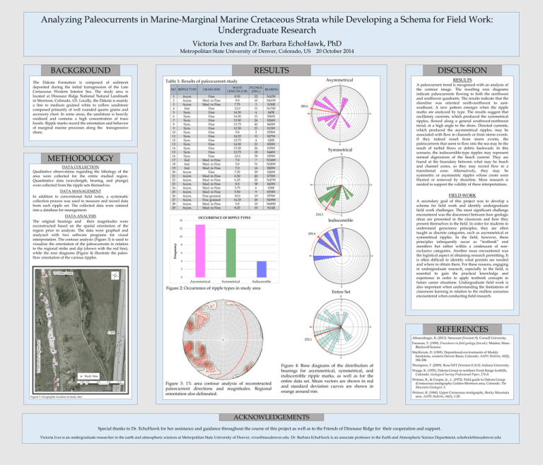
Analyzing Paleocurrents in Marine-Marginal Marine Cretaceous Strata while Developing a Schema for Field Work: Undergraduate Research Victoria Ives and Dr. Barbara EchoHawk, PhD Metropolitan State University of Denver, Colorado, US RESULTS BACKGROUND METHODOLOGY DATA COLLECTION Qualitative observations regarding the lithology of the area were collected for the entire studied region. Quantitative data (wavelength, bearing, and plunge) were collected from the ripple sets themselves. DATA MANAGEMENT In addition to conventional field notes, a systematic collection process was used to measure and record data from each ripple set. The collected data were entered into a database for management. DATA ANALYSIS The original bearings and their magnitudes were reconstructed based on the spatial orientation of the region prior to analysis. The data were graphed and analyzed with two software programs for visual interpretation. The contour analysis (Figure 3) is used to visualize the orientation of the paleocurrents in relation to the regional strike and dip (shown with the red line), while the rose diagrams (Figure 4) illustrate the paleoflow orientation of the various ripples. DISCUSSION Asymmetrical Table 1: Results of paleocurrent study NO. RIPPLE TYPE 1 2 3 4 5 6 7 8 9 10 11 12 13 14 15 16 17 18 19 20 21 22 23 24 25 26 27 28 29 Asym. Asym. Asym. Ind. Sym. Sym. Sym. Sym. Sym. Sym. Sym. Sym. Sym. Sym. Sym. Sym. Ind. Ind. Ind. Asym. Asym. Asym. Asym. Asym. Asym. Asym. Asym. Asym. Asym. 14 GRAIN SIZE Fine Med. to Fine Med. to Fine Fine Fine Fine Fine Fine Fine Fine Fine Fine Fine Fine Fine Fine Med. to Fine Med. to Fine Med. to Fine Fine Med. to Fine Med. to Fine Med. to Fine Med. to Fine Med. to Fine Fine grained Fine grained Med. to Fine Med. to Fine WAVE PLUNGE BEARING LENGTH (CM) (DEG.) 8.50 9.0 7.75 12.0 14.50 14.50 15.50 13.75 12.50 9.0 14.25 12.75 14.50 13.50 12.75 12.0 7.0 5.0 7.0 7.25 6.50 6.25 8.0 3.75 5.50 10.0 14.25 5.0 8.25 32 10 2 11 4 11 26 42 21 2 11 4 21 26 18 39 7 31 16 29 40 22 38 6 9 19 20 10 10 N42W N61W N30E N15W S45E S56W S26W S60W S13W S78W S27W S20E S50W S39W S44W S59W N34W N58W S82W S26W S75W N47W S43W S38E S70W S79W N69W N68W N14E 280.6 Symmetrical 214.3 OCCURRENCE OF RIPPLE TYPES Indiscernible 309.4 10 8 6 4 2 0 Asymmetrical Symmetrical RESULTS A paleocurrent trend is recognized with an analysis of the contour image. The resulting rose diagrams indicate paleocurrents flowing to both the northwest and southwest quadrants. The results indicate that the shoreline was oriented north-northwest to eastsoutheast. A new pattern emerges when the ripple marks are analyzed by type. The results suggest that oscillatory currents, which produced the symmetrical ripples, flowed along a general southwest-northwest trend, at a high angle to the shore. Directed currents, which produced the asymmetrical ripples, may be associated with flow in channels or from storm events. If they indeed result from storm events, the paleocurrents that seem to flow into the sea may be the result of turbid flows or debris backwash. In this scenario, the indiscernible-type ripples may represent normal digressions of the beach current. They are found at the boundary between what may be beach and channel zones, so they may record flow in a transitional zone. Alternatively, they may be symmetric or asymmetric ripples whose crests were blurred or removed by shoreline. More research is needed to support the validity of these interpretations. FIELD WORK 12 Frequency The Dakota Formation is composed of sediment deposited during the initial transgression of the Late Cretaceous Western Interior Sea. The study area is located at Dinosaur Ridge National Natural Landmark in Morrison, Colorado, US. Locally, the Dakota is mainly a fine to medium grained white to yellow sandstone composed primarily of well rounded quartz grains and accessory chert. In some areas, the sandstone is heavily oxidized and contains a high concentration of trace fossils. Ripple marks record the orientation and behavior of marginal marine processes along the transgressive shore. 20 October 2014 Indiscernible Figure 2: Occurrence of ripple types in study area Entire Set A secondary goal of this project was to develop a schema for field work and identify undergraduate field work challenges. The most significant challenge encountered was the disconnect between how geologic ideas are presented in the classroom and how they present themselves in the field. In order for students to understand geoscience principles, they are often taught as discrete categories, such as asymmetrical or symmetrical ripples. In the field, however, these principles infrequently occur as “textbook” end members but rather within a continuum of nonexclusive categories. Another issue encountered was the logistical aspect of obtaining research permitting. It is often difficult to identify what permits are needed and where to obtain them. For these reasons, engaging in undergraduate research, especially in the field, is essential to gain the practical knowledge and experience in order to apply textbook concepts in future career situations. Undergraduate field work is also important when understanding the limitations of classroom learning in relation to the endless scenarios encountered when conducting field research. REFERENCES 252.1 Allmendinger, R. (2013). Stereonet (Version 9). Cornell University. Freeman, T. (1999). Procedures in field geology (1st ed.). Maiden, Mass.: Blackwell Science. MacKenzie, D. (1965). Depositional environments of Muddy Sandstone, western Denver Basin, Colorado. AAPG Bulletin, 49(2), 186-206. Figure 1: Geographic location of study sites Figure 3: 1% area contour analysis of reconstructed paleocurrent directions and magnitudes. Regional orientation also delineated. Figure 4: Rose diagrams of the distribution of bearings for asymmetrical, symmetrical, and indiscernible ripple marks, as well as for the entire data set. Mean vectors are shown in red and standard deviation curves are shown in orange around rim. Thompson, T. (2009). Rose.NET (Version 0.10.0). Indiana University. Waage, K. (1955). Dakota Group in northern Front Range foothills, Colorado. Geological Survey Professional Paper, 274-B. Weimer, R., & Cooper, Jr., L. (1972). Field guide to Dakota Group (Cretaceous) stratigraphy Golden-Morrison area, Colorado. The Mountain Geologist, 9. Weimer, R. (1960). Upper Cretaceous stratigraphy, Rocky Mountain area. AAPG Bulletin, 44(1), 1-20. ACKNOWLEDGEMENTS Special thanks to Dr. EchoHawk for her assistance and guidance throughout the course of this project as well as to the Friends of Dinosaur Ridge for their cooperation and support. Victoria Ives is an undergraduate researcher in the earth and atmospheric sciences at Metropolitan State University of Denver, vives@msudenver.edu. Dr. Barbara EchoHawk is an associate professor in the Earth and Atmospheric Science Department, echohwk@msudenver.edu
