Caltech 11 UF dunes text
advertisement
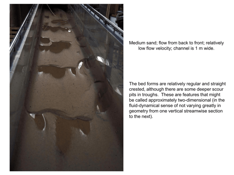
Medium sand; flow from back to front; relatively low flow velocity; channel is 1 m wide. The bed forms are relatively regular and straight crested, although there are some deeper scour pits in troughs. These are features that might be called approximately two-dimensional (in the fluid-dynamical sense of not varying greatly in geometry from one vertical streamwise section to the next). Medium sand; flow from back to front; relatively high flow velocity; channel is 1 m wide. This is the same sand as in the preceding photo, but the flow velocity is higher, leading to much more threedimensional (and steeper) bed forms. Note the prominent scour pits in bedform troughs, which is what leads to large-scale trough cross stratification. Dunes in medium sand; flow is from L to R; approximate effective spacing of yellow marks is 0.25 m You can see from the record of foreset deposits that the shape of the dune has varied a lot in the past. This photo is of the same dune as in the preceding photo, but farther upstream on the stoss side. You can see a succession of smaller-scale superimposed dunes—which are common on large dunes. This a close-up of the crest of the dune in the preceding photos. You can see that the crest height has increased in the recent past: follow the crest upward to the right in the section. Note the bed-load layer on the stoss slope, and the rainout of suspended sand over the lee slope. Arkansas River near Tulsa, Oklahoma Approximately two-dimensional dunes, formed at relatively low flow velocity. The superimposed ripples probably formed during waning flow. Flood-oriented dunes, Parker River estuary, north of Boston, Massachusetts Very regular, two-dimensional dunes, although with some crest sinuosity. The superimposed ripples seem to be oriented in the opposite direction, caused by reversal of the tidal current. The scale board is one meter long. Small river near Atlanta, Georgia; flow from L to R; Dr. Pepper for scale Thee dunes are strongly three-dimensional. Note the prominent scour pits in troughs. Dunes in the Platte River Nebraska; flow from L to R; persons for scale. (Courtesy of Dave Mohrig) These three-dimensional dunes were formed by strong bed-load transport with little suspended load to obscure the bed. Crest of dune, left bank of Mississippi River near Hickman, Kentucky; flow from L to R This is one of a series of giant dunes on a large point bar. The sinuous bands on the lee side are falling-water-level marks. Gravel dunes; size fractions are colored; flow R to L; scale numbers are decimeters. Particle transport over the crest of the dune is well shown. The largest clasts end to end up low on the lee side and in the trough, but some are located well up on the lee side. There is a concentration of finer particles that floor the trough. Follow that back upstream to see that this dune was higher up at earlier times. Tidal dunes, Cobequid Bay, Bay of Fundy, Nova Scotia; flow was from R to L; scale bar is 1 m The simple external geometry of the dune is deceptive: the internal structure is complex. Most sets are oriented to the left, but some are oriented to the right. There must be a dominant flow to the left but a subordinate flow to the right, in this tidal environment. Antidunes, about to break These features form, steepen, break, and then almost smooth out, and then the cycle is repeated. Antidunes, breaking


![Beach Task Force June 19 2014[Icon]](http://s3.studylib.net/store/data/007024040_1-770d150c49a9dddb60a7072fd7d9b509-300x300.png)