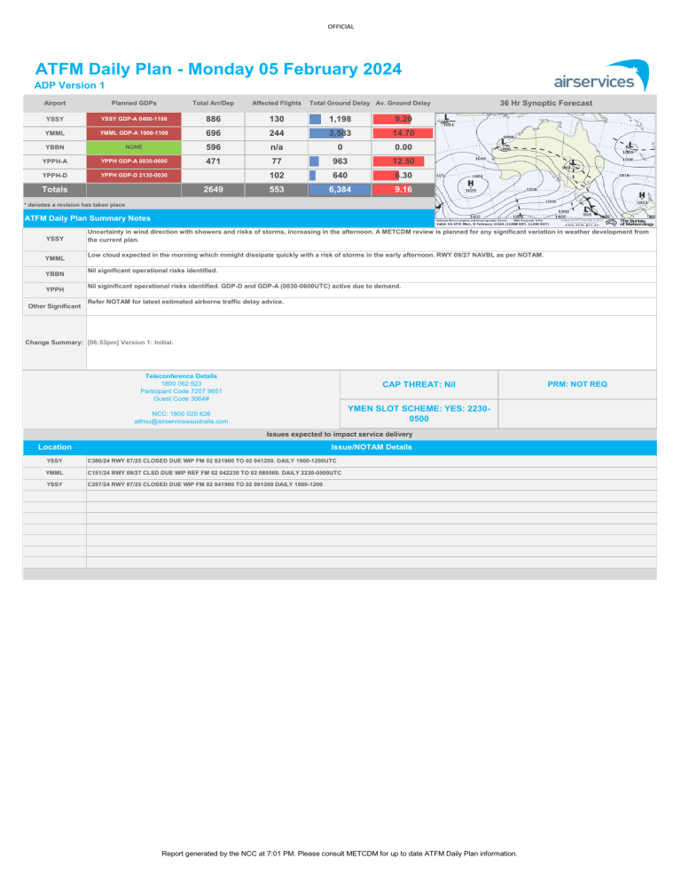
OFFICIAL # ATFM Daily Plan - Monday 05 February 2024 ADP Version 1 Airport Planned GDPs Total Arr/Dep Affected Flights YSSY YSSY GDP-A 0400-1100 886 130 1,198 9.20 YMML YMML GDP-A 1900-1100 696 244 3,583 14.70 YBBN NONE 596 n/a 0 0.00 YPPH-A YPPH GDP-A 0030-0600 471 YPPH-D YPPH GDP-D 2130-0030 Totals 2649 36 Hr Synoptic Forecast Total Ground Delay Av. Ground Delay 77 963 12.50 102 640 6.30 553 6,384 9.16 Synoptic not AVBL Please see BOM Website * denotes a revision has taken place ATFM Daily Plan Summary Notes YSSY YMML YBBN YPPH Other Significant Uncertainty in wind direction with showers and risks of storms, increasing in the afternoon. A METCDM review is planned for any significant variation in weather development from the current plan. Low cloud expected in the morning which mmight dissipate quickly with a risk of storms in the early afternoon. RWY 09/27 NAVBL as per NOTAM. Nil significant operational risks identified. Nil siginificant operational risks identified. GDP-D and GDP-A (0030-0600UTC) active due to demand. Refer NOTAM for latest estimated airborne traffic delay advice. Change Summary: [06:53pm] Version 1: Initial. Teleconference Details 1800 062 923 Participant Code 7207 9651 Guest Code 3064# CAP THREAT: Nil YMEN SLOT SCHEME: YES: 22300500 NCC: 1800 020 626 atfmu@airservicesaustralia.com Issues expected to impact service delivery Location Issue/NOTAM Details YSSY C386/24 RWY 07/25 CLOSED DUE WIP FM 02 021900 TO 02 041200. DAILY 1900-1200UTC YMML C151/24 RWY 09/27 CLSD DUE WIP REF FM 02 042230 TO 02 080500. DAILY 2230-0500UTC YSSY C297/24 RWY 07/25 CLOSED DUE WIP FM 02 041900 TO 02 091200 DAILY 1900-1200 Report generated by the NCC at 7:01 PM. Please consult METCDM for up to date ATFM Daily Plan information. PRM: NOT REQ OFFICIAL # Network Weather Overview Monday 05 February 2024 From now to +72 hours Weather Overview Mean Sea Level Pressure Satellite Picture Rainfall Outlook for tomorrow Picture NOT AVBL - please see BOM website Picture NOT AVBL - please see BOM website Picture NOT AVBL - please see BOM website Brisbane Weather impact risk assessment Major Airports Melbourne Perth Sydney AM Monday Cloud 2500-3500ft. Light showers, mainly offshore. Light S to SW winds, tending moderate NE from late morning. Cloud 1500-2000ft, lifting to 3000ft by late morning; possible showers. Light to moderate S to SW winds. CAVOK. Moderate SE winds, reaching 30 knots aloft. CAVOK with high-based showers in the area. Light NW winds turning ESE late morning. PM Monday Cloud 2500-3500ft. Light showers clearing early afternoon. Moderate NE winds. Cloud 3000-4000ft. Chance TS in the NE TMA. Moderate S winds. CAVOK. Moderate SE winds, then SW sea breeze late afternoon. Showers and possible thunderstorms moving in from the west. Evening cloud 1500-2500ft. Winds uncertain – most likely E to NE. AM Tuesday Patchy cloud 2000-2500ft lifting above 2500ft during the morning. Light W to SSW winds becoming NE late morning. Cloud 3000-4000ft. Light to moderate S to SW winds. PM Tuesday Patchy cloud above 3000ft possibly lowering to 2000ft late evening. Moderate NE winds. Patchy cloud above 4000ft. Moderate S’ly winds. Showers. Chance of thunderstorms CAVOK. Moderate and gusty E to in the TMA. Cloud 1000-2000ft. ESE winds easing. 25-30 knots E’ly Variable winds, tending strong and winds aloft easing. gusty southerly. CAVOK. Moderate E’ly winds possibly becoming SSW late afternoon. Showers, possibly easing later. Chance of storms in N TMA early afternoon. Cloud 1500-3000ft. Gusty S’ly winds. 30-40kt S’ly winds aloft. AM Wednesday Light morning showers. Cloud 1500CAVOK. Moderate E’ly winds, gusty 2500ft lower in showers. Light S’ly Patchy cloud at and above 2000ft. Showers mostly offshore moving at times. 30 knots E’ly winds aloft winds increasing and possibly Light winds mostly from W to SW inland. Cloud 2000-4000ft. Moderate easing turbulence possible early becoming gusty late afternoon. becoming S’ly. S to SE winds gusty at times. morning. Aloft winds increasing 20-30 knots. PM Wednesday Light showers mostly inland. Chance of inland thunderstorms. Showers, chance of thunderstorms CAVOK. Light to moderate E to NE Cloud 2000-4000ft lower in Patchy cloud above 3000ft. Light to in far west TMA. Cloud 2000-4000ft. winds becoming S to SW late showers. Moderate SE winds gusty moderate S’ly winds. Moderate SE winds gusty at times afternoon. at times easing. 25-35 knots SE easing. winds aloft. Significant other phenomena potentially affecting Australian FIRs Volcanic Ash (VA) ≥ FL200 Space Weather Tropical Cyclones Nil current. For the latest information refer to http://www.bom.gov.au/aviation/volcanic-ash/darwin-va-advisory.shtml Nil current. For the latest information refer to http://www.bom.gov.au/aviation/space-weather-advisories/ A Tropical low (06U) in the Coral Sea has a low chance of developing into a Tropical Cyclone later in the week; most likely it will be moving away from Australia by then. For the latest outlook information refer to http://www.bom.gov.au/cyclone/ Weather risk assessment provided by NCC Meteorological Unit – Bureau of Meteorology Contact NCCMET for further detail or advice Phone: 02 6268 4448 Email: nccmet@bom.gov.au Detailed advice from major Airport MET CDM products available at Airservices NOC Portal, https://www.airservicesaustralia.com/noc/ Report generated by the NCC at 7:01 PM. Please consult METCDM for up to date ATFM Daily Plan information. OFFICIAL # SYDNEY - YSSY GDP-A 0400-1100 Monday 05 February 2024 ATFM-CDM Notes METCDM Notes: [1] 1900-2259: Complicated and uncertain weather on Monday with the remnants of TC Kirrily moving from NW NSW in the morning to southern NSW by the end of the day. CAVOK at first with dry northwesterly flow over Sydney; light N to NW surface winds with 20-30kt NW winds above 3000ft. High-based showers in the area and the chance of a thunderstorm in the outer southern TMA. An x-factor is applied due to uncertainty in the winds (see below). [2] 2300-1159: Wind direction becomes uncertain in the late morning and afternoon; winds likely to turn onshore as a light E to SE breeze develops in the late morning, then tending E to NE later in the afternoon. Winds could fluctuate around 060-080° for a lengthy period in the afternoon. [3] 0200-1159: Showers and thunderstorms developing in the afternoon, particularly in the SW TMA, then becoming more likely closer to the port in the evening. Slight chance of isolated storms developing in the N-NW TMA in the afternoon which could impact the aerodrome earlier; an x-factor is applied to the TS>20 rate to account for this risk. Cloud mostly remaining above 5000ft although a few patches around 1500-2000ft may develop towards the end of the day. More widespread rain and storms will develop further away over the Southern Highlands in the afternoon, then moving into the SW TMA in the evening, impacting en route traffic. Variation in the position of the low as it crosses NSW on Monday could lead to significantly different weather at YSSY - a review will be conducted tomorrow. NCC DLM Notes: [Nil DLM Notes] SM Notes: [1] 0200-0259: No SYTM available GDP Notes Uncertainty in wind direction with showers and risks of storms, increasing in the afternoon. A METCDM review is planned for any significant variation in weather development from the current plan. Tabulated Data Time (Hour UTC) 041900 042000 042100 042200 042300 050000 050100 Runway Mode 34 IVA 34 IVA 34 IVA 34 IVA 34 IVA 16 IVA 16 IVA Rate 34 46 46 46 46 46 46 METCDM Notes 1 1 1 1 2 2 2 Segmentation 1 1 1 1 1 1 1 050200 050300 050400 050500 050600 050700 050800 050900 051000 051100 0 16 TS>20 16 TS>20 16 TS>20 34 TS>20 34 TS>20 34 TS>20 34 TS>20 34 TS<20 34 TS<20 34 TS<20 30 34 32 32 32 32 32 26 22 21 Segmentation and Notes 2&3 2&3 2&3 2&3 2&3 2&3 2&3 2&3 2&3 2&3 1 2 2 2 2 2 2 2 2 2 Bar Graph Report generated by the NCC at 7:01 PM. Please consult METCDM for up to date ATFM Daily Plan information. 0 OFFICIAL # MELBOURNE - YMML GDP-A 1900-1100 Monday 05 February 2024 ATFM-CDM Notes METCDM Notes: [1] 1900-2359: A cool change will move through Melbourne in the early hours of Monday morning. Moderate SW winds will be established at the aerodrome by the start of this program, with areas of cloud around 800-1200ft in the early morning, lifting quickly to 1500-2000ft. It is possible the cloud will not get any lower than SCT 1800ft in which case a review would improve the rates in the morning. A few light showers across the TMA, both from the mid-level cloud band above 12000ft and also in the low-level southwesterly flow, but only a low chance of reducing visibility significantly - IMCA with x-factors is planned to account for this risk. [2] 0000-1259: Cloud lifting above 3000ft in the late morning and afternoon. Showers clearing east. Moderate S winds varying 160-200°, easing in the evening with a return to RWY 16/27 planned. Slight chance of an early afternoon storm in the far eastern TMA about the hills, but more likely further east. [3] 2200-0459: RWY 09/27 closed from 2230-0500Z (NOTAM C151/24). NCC DLM Notes: [Nil DLM Notes] SM Notes: [Nil SMTM Notes] GDP Notes Low cloud expected in the morning which mmight dissipate quickly with a risk of storms in the early afternoon. RWY 09/27 NAVBL as per NOTAM. Tabulated Data Time (Hour UTC) 041900 042000 042100 042200 042300 050000 050100 050200 050300 050400 050500 050600 050700 050800 050900 051000 051100 051200 Runway Mode 16/27 IMCB 16/27 IMCA 16/27 IMCA 16 IMCA 16 VMC 16 VMC 16 VMC 16 VMC 16 VMC 16 VMC 16 VMC 16 VMC 16 VMC 16 VMC 16/27 VMCB 16/27 VMCB 16/27 VMCB 16/27 VMCB Rate 20 21 22 22 23 24 24 24 24 24 24 24 24 24 25 25 25 25 Segmentation and Notes METCDM Notes 1 1 1 1&3 1&3 2&3 2&3 Segmentation 1 1 1 1 1 1 1 2&3 2&3 2&3 2 2 2 2 2 2 2 2 1 2 2 2 2 2 2 2 2 2 2 Bar Graph Report generated by the NCC at 7:01 PM. Please consult METCDM for up to date ATFM Daily Plan information. OFFICIAL # BRISBANE - Nil GDP Monday 05 February 2024 ATFM-CDM Notes METCDM Notes: [1] 2000-1259: Light northeasterly flow continues on Monday with a ridge of high pressure overhead. Cloud mostly above 3000ft, with some patches around 2000ft early, then clearing to CAVOK for most of the day before returning around 2000ft late evening. A few showers well offshore in the eastern TMA in the morning. Light to moderate NE winds all day; slight chance of a light SSW surface wind for the first few hours of the program. NCC DLM Notes: [Nil DLM Notes] SM Notes: [Nil SMTM Notes] GDP Notes Nil significant operational risks identified. Tabulated Data Time (Hour UTC) 042000 042100 042200 042300 050000 050100 050200 050300 050400 050500 050600 050700 050800 050900 051000 051100 051200 Runway Mode 01 VMC 01 VMC 01 VMC 01 VMC 01 VMC 01 VMC 01 VMC 01 VMC 01 VMC 01 VMC 01 VMC 01 VMC 01 VMC 01 VMC 01 VMC 01 VMC 01 VMC Rate 32 32 32 32 34 34 34 34 34 34 34 34 34 34 34 32 32 METCDM Notes 1 1 1 1 1 1 1 Segmentation 1 1 1 1 1 1 1 Segmentation and Notes 1 1 1 1 1 1 1 1 1 1 1 2 2 2 2 2 2 2 2 2 Bar Graph Report generated by the NCC at 7:01 PM. Please consult METCDM for up to date ATFM Daily Plan information. 0 OFFICIAL # PERTH Arrivals - YPPH GDP-A 0030-0600 Arrivals - YPPH GDP-D 2130-0030 Monday 05 February 2024 ATFM-CDM Notes METCDM Notes: [1] 2200-1359: Dry southeasterly flow with a ridge of high pressure to the south. Moderate SE surface winds, tending light southerly in the early afternoon and then turning moderate SW with a late afternoon sea breeze. CAVOK all day. 20-25kt ESE winds aloft in the early morning may cause some issues on approach with a risk of wind shear. NCC DLM Notes: [Nil DLM Notes] SM Notes: [Nil SMTM Notes] GDP Notes Nil siginificant operational risks identified. GDP-D and GDP-A (0030-0600UTC) active due to demand. Tabulated Data Time (Hour UTC) 042200 042300 050000 050100 050200 050300 050400 050500 050600 050700 050800 050900 051000 051100 051200 051300 Runway Mode 21 VMC 21 VMC 21 VMC 21 VMC 21 VMC 21 VMC 21 VMC 21 VMC 21/24 VMC 21/24 VMC 21/24 VMC 21/24 VMC 21/24 VMC 21/24 VMC 21/24 VMC 21/24 VMC Rate-Arrs 24 24 24 24 24 24 24 24 26 26 26 26 26 26 26 26 40 40 40 METCDM Notes 1 1 1 1 1 1 Segmentation 1 1 1 1 1 1 Rate-Deps 42100 40 Segmentation and Notes 1 1 1 1 1 1 1 1 1 1 2 2 2 2 2 2 2 2 2 2 Bar Graph Report generated by the NCC at 7:01 PM. Please consult METCDM for up to date ATFM Daily Plan information.


