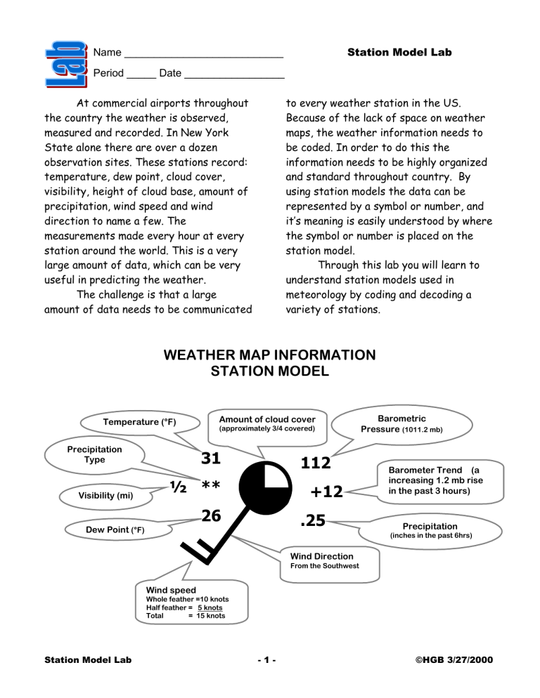
Station Model Lab Name ___________________________ Period _____ Date _________________ At commercial airports throughout the country the weather is observed, measured and recorded. In New York State alone there are over a dozen observation sites. These stations record: temperature, dew point, cloud cover, visibility, height of cloud base, amount of precipitation, wind speed and wind direction to name a few. The measurements made every hour at every station around the world. This is a very large amount of data, which can be very useful in predicting the weather. The challenge is that a large amount of data needs to be communicated to every weather station in the US. Because of the lack of space on weather maps, the weather information needs to be coded. In order to do this the information needs to be highly organized and standard throughout country. By using station models the data can be represented by a symbol or number, and it’s meaning is easily understood by where the symbol or number is placed on the station model. Through this lab you will learn to understand station models used in meteorology by coding and decoding a variety of stations. WEATHER MAP INFORMATION STATION MODEL Temperature (°F) Precipitation Type Visibility (mi) Amount of cloud cover (approximately 3/4 covered) 31 112 ½ ** +12 26 Dew Point (°F) .25 Barometric Pressure (1011.2 mb) Barometer Trend (a increasing 1.2 mb rise in the past 3 hours) Precipitation (inches in the past 6hrs) Wind Direction From the Southwest Wind speed Whole feather =10 knots Half feather = 5 knots Total = 15 knots Station Model Lab -1- ©HGB 3/27/2000 Procedures Air Pressure: when coding air pressure on a station model, use the following rule: a. if the air pressure on the station model is 500 or more, place a 9 in front of this number. Also put a decimal point in front of the last number EX: 588-- 958.8 millibars b. if the air pressure number on the station model is less than 500 add a 10 in front of the number. Also put a decimal point in front of the last number EX: 091=1009.1 millibars Past Pressure: When calculating the air pressure for three hours previous use the following rule: a. if the station model displays a + some number there was an increase in the barometric pressure. Place a decimal between the 2 digits and subtract the number from the current air pressure to get the pressure from 3 hours ago. EX +12= 1.2 mb increase so the past pressure is lower by 1.2 mb. b. if the station model displays a - some number the was an decrease in the barometric pressure. Place a decimal between the 2 digits and add the number to the current air pressure to get the pressure from 3 hours ago. EX -24= 2.4 mb decrease so the past pressure is higher by 1.2 mb. c. Temperature and Dew point: Are always reported in degrees Fahrenheit (°F) these may need to be converted to degrees Celsius (°C) using the ESRT Wind direction is measured by where the wind originates. The stick of the station models points in the direction of where the wind comes from. The flags on the stick approximate the speed of the wind, a short flag: 5 knots, a long flag 10 knots and triangle is 50 knots. A knot equals 1.85km/hr or 1.2 mph Cloud cover is determined by how much of the visible sky is filled with clouds. It is usually done in estimates of 10th’s. AN obstructed view is when the observer, for some reason, could not see the sky… like at night. Cloud Cover Symbols Clear Sky 1/10 Cover 1/4 Cover 4/10 Cover 1/2 Cover 6/10 Cover 3/4 Cover 9/10 Overcast Cover Sky Obstructed View Precipitation may fall to the earth in many different forms. The form is indicated by a symbol shown below. The water equivalent (the water or melted form of the precipitation) for the last three hours is reported in the station model using inches. Precipitation Symbols: Rain Showers Station Model Lab Hail * Snow , Drizzle -2- Sleet Fog Thunderstorm ©HGB 3/27/2000 Part 1 Using the station models below, decode the weather conditions and record the information displayed in the following table: Station 1 Station 2 65 = 64 998 -30 0.2 84 011 +01 60 Station 3 Station 4 40 001 70 982 , +10 • -93 1.5 65 0.3 38 Station 5 28 * 25 Weather Element Station 1 012 -22 Station 2 Station 3 Station 4 Station 5 Temperature (°C) Temperature (°F) Barometric Pressure (mb) Precipitation Type Percent of Sky covered by clouds Wind Direction Wind Speed (Knots) The pressure three Hours ago? (nb) Station Model Lab -3- ©HGB 3/27/2000 Part 2: In the chart below, you find meteorological data that was taken at several different New York State airports. Use this data to create station models for each city listed in the table. Wind City Temp °F De w point Direction Speed Rochester 69 58 SW Buffalo 60 45 Syracuse 70 New York Present Air Press. Sky 16 1016.9 50% none NE 5 1030.1 10% none 69 SW 20 998.2 25% drizzle 72 72 W 30 986.4 100% thunder Storm Binghamton 71 69 NW 35 999.1 90% sleet Albany 32 32 S 10 1000.0 overcast snow Rochester Buffalo Syracuse New York Binghamton Albany Station Model Lab -4- Weather ©HGB 3/27/2000 Conclusion: Study the weather stations shown to the right Write the letter (or letters) of the weather station(s) next to each description of weather conditions. a. Wind NW at 40 miles per hour : _________________ b. Wind SE at 15 miles per hour : _________________ c. Overcast : _________________ d. Clear sky : _________________ e. Thunderstorm: _________________ f. Closest to the warm front : _________________ g. Closest to the cold front : _________________ Shade the area of the mT air mass in the diagram below: X Station Model Lab -5- ©HGB 3/27/2000 Matching Questions On the blank line, write the letter of the item in Column B that is most closely related to the item in column A. Column A Column B ______1. Large sections of troposphere with same temperature and humidity ______2. Boundary between two air masses not moving in relation to each other. ______3. Warm air mass overtakes cold air mass ______4. Cold air mass overtakes warm air mass ______5. Brief local storm with thunder and lightning ______6. Severe, narrow storm with fast, swirling winds ______7. Large, tropical cyclone with heavy rains and winds ______8. severe storm with precipitation of snow and ice Station Model Lab -6- a. warm front b. winter storm c. occluded front d. hurricane e. stationary front f. cold front g. air mass h. tornado i. thunderstorm ©HGB 3/27/2000

