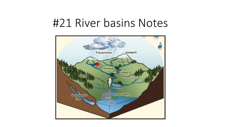
#21 River basins Notes Freshwater • Water is one of the most common substances on the surface of the Earth • Water is the only substance on Earth that occurs naturally as a solid, a liquid, and a gas. • It is often referred to as ‘the universal solvent' because so many other substances dissolve in it. • This characteristic is one reason that the water encountered on Earth is rarely pure. Freshwater • Water covers approximately 71% of the Earth's surface. Most of this water (97%) is not drinkable because it is saltwater. • The majority of freshwater (3%) exists in ice caps and glaciers in oceans. • 70% of the freshwater is frozen. Of the 30% that is not frozen, approximately a half of a percent is available to supply living organisms with what they need to survive. • The availability of water varies with local geography and allows humans to utilize water as a resource. *Where does runoff go? The goal of all water is to make it to the ocean. In order to achieve this, water will flow from a higher to lower elevation above ground as runoff, or beneath the ground as groundwater. Todays focus is to study the movement of runoff water that falls on land and doesn’t get absorbed into the ground *Where does runoff go? As precipitation falls back down towards the Earth due to gravity, mountain ranges (higher elevations) are responsible for forcing water to choose a direction in which it will flow down. A divide is the mountain peak separating one drainage basin from another *Where does runoff go? • Tributaries are small bodies of moving water like creeks, streams, channels, etc. • The land in which the tributary water flows on are called watersheds. • Divides forces water into different watersheds *Watersheds will eventually meet and merge with other watersheds, forming a larger body of freshwater called a river. *Where does runoff go? A drainage/river basin is the portion of land drained by a river and its tributaries. • River basins are made up of multiple watersheds AND the various streams and creeks that flow downhill into one another, joining at the river. River Basins •Everyone lives in a river basin. •Even if they do not live near the water, land-dwellers live on land that drains into a watershed or river. •Every stream, river, and lake are located in a river basin *After water flows into a river, what’s next? • After the freshwater runs off the mountain and into rivers, its goal is to still make it to the saltwater ocean. • The area in between where freshwater meets saltwater is called an estuary. *Estuaries • Estuaries are where freshwater (from rivers, streams, creeks) meets saltwater (ocean) • Also known as brackish water F (land that drains water) C (Mountain Peak) B D A Stop here…. Here is an example of River or Drainage Basin. Let’s identify the watersheds • How many smaller watersheds are in this river/drainage basin? • At least 9, maybe more? • Explanation of Watersheds – Watersheds! (5:21) • https://www.youtube.com/watch?v=2pwW2rlGIa8 • Watersheds quick and fast explanation • https://www.youtube.com/watch?v=QOrVotzBNto#action=share • (1:17) So lets draw a model *Estuaries have…. • Estuaries have twice the life because 2 ecosystems are colliding • Double the plant life • Double the nutrients • Double the breeding & feeding possibilities • https://oceanservice.noaa.gov/facts/estuary.html (2mins) Two types of estuaries you must be familiar with: Salt marshes and mangrove forests • Create a Venn diagram or a double T chart comparing and contrasting them in your notes. You must find a minimum of 3 differences and 3 similarities Where to start: • Textbook page C117 • http://marinebio.org/oceans/estuaries-salt-marshesmangroves/ 2 types of estuaries SALT MARSHES • Atlantic Carolina coasts and cooler regions • Nutrient rich soil promotes growth of grasses • Protects shoreline from washing away BOTH: • Great breeding area • Protects coastline • Great nurseries to plants MANGROVES • Louisiana & gulf and warmer regions • Hurricane proof trees due to thick tree roots • Reduces erosion End… River Basin Analogy…. A bathtub catches all water falling within its’ sides, sending it down the drain and eventually to a large treatment plant. This is similar to drainage basins because water falls within surrounding land, to a central river and out to an estuary or ocean. *Salinity – is the amount of dissolved salts within a body of water. • The saltier the water, the more saline CONCEPT CHECK Salinity increases as you move from(what area) _______________ to (what area)________________. How do you know? 1. Is the land above a water table permeable or impermeable? How do you know? 2. Water will trickle down within the spaces of rock until it reaches what? 3. According to this diagram, how do we access groundwater? 4. Explain what the diagram is trying to environmentally warn us about? A-E-I-O-U A – AIM (What is the purpose of this video? How does it relate to what we are learning?) • Grab a copy of the AEIOU Chart E – EMOTION (describes how a part of the video made you feel) • You will be filling this out as we watch the video clip on Wake County, NC well-water I – INTERESTING • https://www.youtube.c om/watch?v=DKi9_jMS ITI O – OH! (A fact or something said that surprised you.) U – UMM? (a question you may still have after watching the video) Recap… Some water hits land and seeps into the ground in aquifers that we can access by springs and wells. But what about the water that isn’t absorbed in the ground? If the water doesn’t get absorbed into the ground, then it is called run-off.


