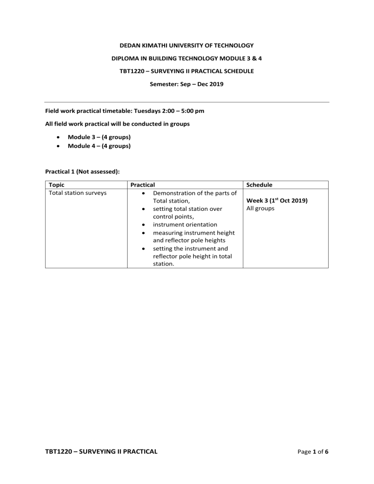
DEDAN KIMATHI UNIVERSITY OF TECHNOLOGY DIPLOMA IN BUILDING TECHNOLOGY MODULE 3 & 4 TBT1220 – SURVEYING II PRACTICAL SCHEDULE Semester: Sep – Dec 2019 Field work practical timetable: Tuesdays 2:00 – 5:00 pm All field work practical will be conducted in groups Module 3 – (4 groups) Module 4 – (4 groups) Practical 1 (Not assessed): Topic Total station surveys Practical Demonstration of the parts of Total station, setting total station over control points, instrument orientation measuring instrument height and reflector pole heights setting the instrument and reflector pole height in total station. TBT1220 – SURVEYING II PRACTICAL Schedule Week 3 (1st Oct 2019) All groups Page 1 of 6 Practical 2 (15 marks): Total station surveys Observation of Horizontal and Vertical angles Week 4 & 5 (8th and 15th oct) Instructions: You are required to carry out the assignment according to the groups I have created. Check your group members. The group leaders are assigned and are therefore required to lead the group during the field work practical. Horizontal and Vertical angles Observation: 1. By closing the horizon: Procedure: Set and orient total station of a known control point (e.g DKUT) Measure the instrument height and reflector pole height and set them accordingly in the total station. Observe horizontal angles from the instrument station to the other three new points (e.g. A, B, C) measure the angles starting with point A to C continuing clockwise and back to A thereby completing the circle. Record all the readings in face left (clockwise) and face right (anticlockwise). Book the vertical angle readings (Zenith angle) for each of the new stations in both faces (FL & FR) Compute the misclosures in Face Left and Face Right measurements and apply the corrections. Reduce the observations by getting the mean measurements (FL and FR) for each measured point. To submit: A technical report that should include: o Raw recorded data in the field. o Sketch showing area where observations were made. o Final angles measurements. Submission Deadline: Thursday 17th October 2019 TBT1220 – SURVEYING II PRACTICAL Page 2 of 6 Practical 3 (15 marks): Total station surveys Observation of a link traverse Week 6 & 7 (22nd and 29th oct) Instructions: You are required to carry out the assignment as per the groups created. The group leaders are assigned and are therefore required to lead the group during the field work practical. Objective: Link traverse observation and computations. Task: Field reconnaissance; to select the locations of the new traverse points. Adopt appropriate control points from these known traverse points to begin and close your traverse network (DKUT, DeKUT5, DeKUT6, DeKUT7, DeKUT8, DeKUT9, TR1, TR2, TR14, TR15, TR16). Locate other 4 new points with pegs at distances of about 100 – 150 meters apart within DeKUT grounds. Observe whole circle bearings for all the traverse lines in both faces (Face Left and Face right) and book your readings Check for the acceptable error tolerances in angular measurements (refer to your notes). Our total stations have an accuracy of 7”. Compute and adjust your traverse Give the new traverse point’s coordinates. To submit: A technical report that should include: o Raw recorded data in the field. o A sketch showing the distribution of the observed points. o Bearing sheet. o Traverse computations sheets o Final coordinates list of the new traverse points Submission Deadline: Thursday 31st October 2019 TBT1220 – SURVEYING II PRACTICAL Page 3 of 6 List of controls: PT.ID NORTHINGS(M) EASTINGS(M) ELEVATION REMARKS DKUT 9956561.789 272861.243 1773.189 short pillar DeKUT5 9956706.379 272693.643 1779.596 I.P.C (old) DeKUT6 9956819.541 272707.334 I.P.C (old) DeKUT7 9956825.252 272903.573 1781.021 I.P.C (old) DeKUT8 9956892.362 272848.129 1782.931 I.P.C (old) DeKUT9 9956898.084 272689.260 1787.609 I.P.C (old) TR1 9956481.024 273003.383 I.P.C (New) TR2 9956414.237 273172.486 I.P.C (New) TR14 9956413.690 273357.500 I.P.C (New) TR15 9956475.352 273173.593 I.P.C (New) TR16 9956720.647 272965.678 I.P.C (New) TBT1220 – SURVEYING II PRACTICAL Page 4 of 6 Practical 4 (10 marks): Earthworks Volume computations using contour lines Week 10 (19th Nov 2019) Volume computations from contours Materials: Topographical maps scale: 1:50,000 Digital planimeter Task: 1. Identify at least 5 closing contour lines; mostly those indicating depressions or hilly areas A clip from topo map showing closing contours 2. Note the contour interval (vertical interval) from the legend is in feet! Convert the measurement to meters 3. Measure the areas enclosed by these contour lines using the planimeter and book your readings 4. Assuming these contours encloses a reservoir, Calculate the volume using a. Trapezoidal rule for volumes b. Prismoidal rule for volumes To submit: A report that includes: The group members The information on the topographical sheet chosen and a screen shot of the contours measured. The volume computations as per number 4 above Deadline for submission: 14th November 2019 TBT1220 – SURVEYING II PRACTICAL Page 5 of 6 Practical 5 Curves (10 marks): Setting Out horizontal curves Week 8 & 9 (5th and 12th Nov 2019) Horizontal curve staking (Deflection method for stationing) (Refer to your notes pg. 76-78) Solve this curve ranging problem and implement it on a selected section on DeKUT grounds (Mr. Julius will direct you on where to implement the curve setting out with pegs on the ground.) Description of the Curve setting out Problem: The centre line of two straights is projected forward to meet at I, the deflection angle being 30˚. If the straights are connected by a circular curve of radius 200m, tabulate all the setting out data, assuming 20-m chords on through chain-age basis, the chain-age of I, being 2259.59 m. To submit: A report that includes: The group members Calculations of setting out data Field sketches and photos of implemented set out curves (i.e showing pegs placed on ground). Deadline for submission: 21st November 2019 TBT1220 – SURVEYING II PRACTICAL Page 6 of 6
