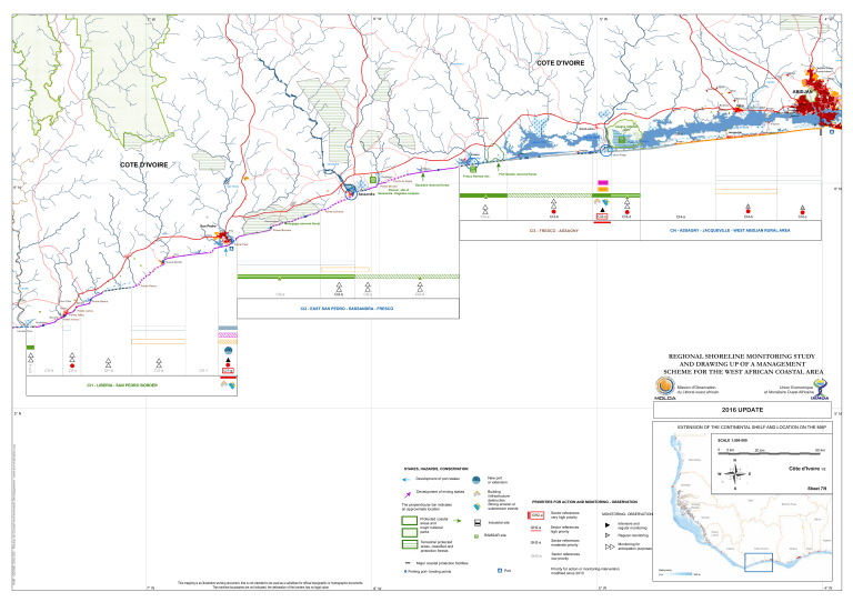
6° W 7° W 5° W 4° W Boubo COTE D'IVOIRE Niouniourou Lamé Anyama-Aouabo Anyama-Adjamé Akoupé Abobo Agnebi Ousrou Lopou ABIDJAN Orbaf Dibrimou Dabou Bouboury Bandama Agbaye Kosrou Songon-Dagbé Songon Mopoyem Wawapéko Azagny national park Grand-Lahou Lagune Tagba m Lagune Tadio Jacqueville Canal d'Assigny Ahua Mbokrou Addah Bimbresso Songon-Kassemblé Audouin N'dyéni Lagune Ebrié Tiémé Adiapo-Doumé Abadjin-Kouté Akrou Avagou ž Sassako-Bégniny Davo Groguida Ebonou Fresco Lagune Ngi COTE D'IVOIRE Lahou-Plage Sassandra Kosso m Fresco Ramsar site Dagbégo Sassandra Port Gautier reserved forest Pointe de Kapet Pointe Brouko San Pedro 6° N m Dassieko reserved forest 6° N Ramsar site of Sassandra - Dagbebo complex Pointe Enframa CI3-a Kounoukou San Pedro Poro Niero CI3-b CI3-c CI3-d CI4-b CI4-a CI4-c Monogaga reserved forest CI4 - ASSAGNY - JACQUEVILLE - WEST ABIDJAN RURAL AREA CI3 - FRESCO - ASSAGNY Pointe Monoho Baba ž Pointe Pata Ouro Grand-Bérébi Pointe Klama Cavally CI2-a Cavalla Pont Yaka Sekréké Tabou Baoulo Soublaké CI2-b CI2-d CI2-c Pointe Basha CI2 - EAST SAN PEDRO - SASSANDRA - FRESCO Pointe James Pointe Tafou Pointe Yennoi CI1-a Cavalla Town CI1-b CI1-c CI1-d CI1-e CI1-f REGIONAL SHORELINE MONITORING STUDY AND DRAWING UP OF A MANAGEMENT SCHEME FOR THE WEST AFRICAN COASTAL AREA CI1-g CI1 - LIBERIA - SAN PEDRO BORDER Mission d'Observation du Littoral ouest africain Union Economique et Monétaire Ouest Africaine 2016 UPDATE 5° N 5° N EXTENSION OF THE CONTINENTAL SHELF AND LOCATION ON THE MAP EAM - GEOME, EOS.D2C - Réseau de Conseil environnement Développement - www.eco-evaluation.org SCALE 1:500 000 0 5 km N Mauritania NW STAKES, HAZARDS, CONSERVATION Building /infrastructure destruction Strong erosion or submersion events Development of mining stakes The perpendicular bar indicates an approximate location Sheet 7/9 S Mali PRIORITIES FOR ACTION AND MONITORING - OBSERVATION GH2-a RAMSAR site Terrestrial protected areas, classified and protection forests SE Niger Industrial site m Côte d'Ivoire 1/2 E SW Senegal GH2-a Protected coastal areas and major national parks NE W New port or extension Development of port stakes 50 km 20 km GH2-a GH2-a Sector references very high priority Burkina Faso Guinea Bissau MONITORING- OBSERVATION Guinea Benin Intensive and regular monitoring Sector references high priority Sierra Leone Regular monitoring Sector references moderate priority Nigeria Monitoring for anticipation purposes Liberia Côte d'Ivoire Ghana Togo Sector references low priority Major coastal protection facilities Fishing port- landing points 7° W This mapping is an illustrative working document, that is not intended to be used as a substitute for official topographic or hydrographic documents. The maritime boundaries are not indicated, the delineation of the borders has no legal value. 6° W Port Priority for action or monitoring-intervention modifiied since 2010 5° W Bathymetry 0m 250 m 4° W


