GIS Practical Exercise: Coordinate Systems & Spatial Analysis
advertisement

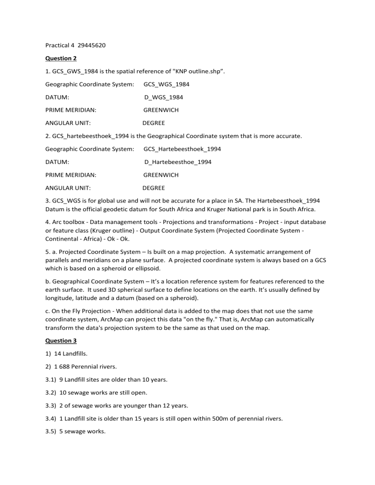
Practical 4 29445620 Question 2 1. GCS_GWS_1984 is the spatial reference of "KNP outline.shp”. Geographic Coordinate System: GCS_WGS_1984 DATUM: D_WGS_1984 PRIME MERIDIAN: GREENWICH ANGULAR UNIT: DEGREE 2. GCS_hartebeesthoek_1994 is the Geographical Coordinate system that is more accurate. Geographic Coordinate System: GCS_Hartebeesthoek_1994 DATUM: D_Hartebeesthoe_1994 PRIME MERIDIAN: GREENWICH ANGULAR UNIT: DEGREE 3. GCS_WGS is for global use and will not be accurate for a place in SA. The Hartebeesthoek_1994 Datum is the official geodetic datum for South Africa and Kruger National park is in South Africa. 4. Arc toolbox - Data management tools - Projections and transformations - Project - input database or feature class (Kruger outline) - Output Coordinate System (Projected Coordinate System Continental - Africa) - Ok - Ok. 5. a. Projected Coordinate System – Is built on a map projection. A systematic arrangement of parallels and meridians on a plane surface. A projected coordinate system is always based on a GCS which is based on a spheroid or ellipsoid. b. Geographical Coordinate System – It’s a location reference system for features referenced to the earth surface. It used 3D spherical surface to define locations on the earth. It’s usually defined by longitude, latitude and a datum (based on a spheroid). c. On the Fly Projection - When additional data is added to the map does that not use the same coordinate system, ArcMap can project this data "on the fly." That is, ArcMap can automatically transform the data's projection system to be the same as that used on the map. Question 3 1) 14 Landfills. 2) 1 688 Perennial rivers. 3.1) 9 Landfill sites are older than 10 years. 3.2) 10 sewage works are still open. 3.3) 2 of sewage works are younger than 12 years. 3.4) 1 Landfill site is older than 15 years is still open within 500m of perennial rivers. 3.5) 5 sewage works. 4) Heritage sites within 2.5 km -Town Hall. Voortrekker Street. Dewetsdorp - St Bartholomew Anglican Church. 27 van der Wath Street. Dewetsdorp. - Orange Free state Botanical gardens, Bloemfontein. -Town Hall. De Beer Street. Wepener. 5) 1 landfill site that falls within areas with a GVA of less than five for Sector 4. 6) 4 heritage sites are within 135 meters of a perennial river. 7) Rock Paintings. Ventershoek. Wepener Districk. 8) 4327, 760222ha 9) 48,033829 km² 10) 55,778565 km 11) 36412, 2263m


