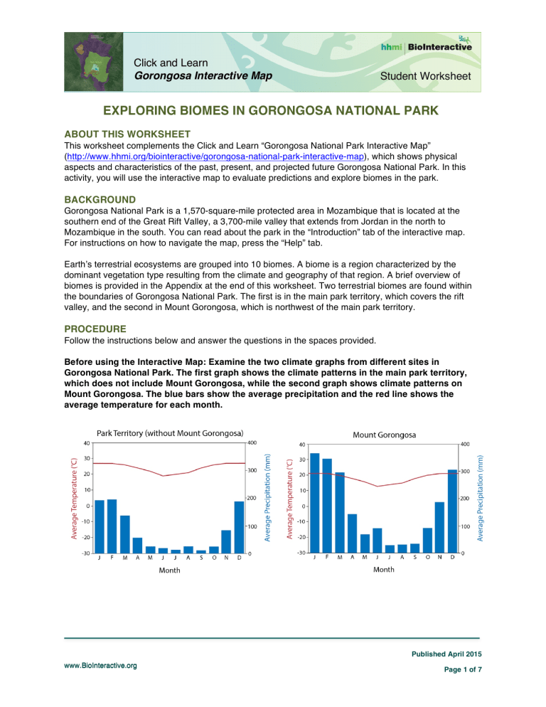
Click and Learn Gorongosa Interactive Map Student Worksheet EXPLORING BIOMES IN GORONGOSA NATIONAL PARK ABOUT THIS WORKSHEET This worksheet complements the Click and Learn “Gorongosa National Park Interactive Map” (http://www.hhmi.org/biointeractive/gorongosa-national-park-interactive-map), which shows physical aspects and characteristics of the past, present, and projected future Gorongosa National Park. In this activity, you will use the interactive map to evaluate predictions and explore biomes in the park. BACKGROUND Gorongosa National Park is a 1,570-square-mile protected area in Mozambique that is located at the southern end of the Great Rift Valley, a 3,700-mile valley that extends from Jordan in the north to Mozambique in the south. You can read about the park in the “Introduction” tab of the interactive map. For instructions on how to navigate the map, press the “Help” tab. Earth’s terrestrial ecosystems are grouped into 10 biomes. A biome is a region characterized by the dominant vegetation type resulting from the climate and geography of that region. A brief overview of biomes is provided in the Appendix at the end of this worksheet. Two terrestrial biomes are found within the boundaries of Gorongosa National Park. The first is in the main park territory, which covers the rift valley, and the second in Mount Gorongosa, which is northwest of the main park territory. PROCEDURE Follow the instructions below and answer the questions in the spaces provided. Before using the Interactive Map: Examine the two climate graphs from different sites in Gorongosa National Park. The first graph shows the climate patterns in the main park territory, which does not include Mount Gorongosa, while the second graph shows climate patterns on Mount Gorongosa. The blue bars show the average precipitation and the red line shows the average temperature for each month. Published April 2015 www.BioInteractive.org Page 1 of 7 Click and Learn Gorongosa Interactive Map Student Worksheet 1. For each graph, describe the trend in the amount of rainfall throughout the year. Include which month(s) have the highest rainfall and which month(s) have the lowest rainfall. 2. For each graph, describe the trend in the temperature throughout the year. Include which month(s) have the highest temperature and which month(s) have the lowest temperature. 3. Based on these two graphs, how are temperature and rainfall trends related? Use evidence to support your claim. 4. Based on these temperature and precipitation graphs, predict which biome you think each site belongs to. Use evidence from the graphs to support your reasoning. (You may use a textbook or other provided resources to compare these graphs with biome climate descriptions.) Published April 2015 www.BioInteractive.org Page 2 of 7 Click and Learn Gorongosa Interactive Map Student Worksheet Open the Gorongosa Interactive Map Click and Learn. Advance through the introduction to learn where Gorongosa National Park is located. Select the “Park Territory” and “Biomes” layers in the menu on the left on the present map view and make sure that all other layers are turned off. Toggle the “Park Territory” layer on and off to see the biome identified for Mount Gorongosa and the rest of the Park Territory. Click the labels for the two biomes on the map to read their descriptions. 5. How does the information on the two biomes in the interactive map compare to your prediction in question 4? Is the information about temperature and precipitation of the two biomes in the map the same or different from the climate graphs on the first page? Select the “Vegetation Types” layer, and click the vegetation labels on the map to read their descriptions. 6. List the types of vegetation present in each biome. Explain how temperature and precipitation might influence the vegetation within each biome. Biome Type: ________________________________ Vegetation Types Temperature Influence Precipitation Influence Published April 2015 www.BioInteractive.org Page 3 of 7 Click and Learn Gorongosa Interactive Map Student Worksheet Biome Type: ________________________________ Vegetation Types Temperature Influence Precipitation Influence Research the average monthly rainfall and temperature in the city where you live using the website www.climate-data.org. Generate a climate graph for your city using the data in the climate table in the empty graph below. Model your climate graph after the Gorongosa graphs by plotting the temperature data as a line graph and the precipitation data as a bar graph. Published April 2015 www.BioInteractive.org Page 4 of 7 Click and Learn Gorongosa Interactive Map Student Worksheet 7. Using evidence from your climate graph and the biome resources used in question 4, which biome best describes your region? Why? 8. Describe how rainfall trends in your region compare to rainfall trends at the two Gorongosa sites: Does it rain during the same time of year in your region as at the two Gorongosa sites? Does it rain the same amount? Explain the similarities or differences. 9. Describe how temperature trends in your region compare to temperature trends at the two Gorongosa sites. Explain your answers. 10. Based on your own observations of nature or using provided resources, describe the vegetation in your region and explain how it differs from that of the two Gorongosa sites. Published April 2015 www.BioInteractive.org Page 5 of 7 Click and Learn Gorongosa Interactive Map Student Worksheet 11. In addition to climate, what other factors might determine biomes? (You may use a textbook or other resources. Please cite your source of information.) 12. Why do you think scientists study biomes in a place like Gorongosa? Why is it important to understand the biome where you live? Published April 2015 www.BioInteractive.org Page 6 of 7 Click and Learn Gorongosa Interactive Map Student Worksheet APPENDIX: TERRESTRIAL BIOMES Earth’s 10 terrestrial biomes are: Tropical rain forests experience high year-round temperatures and rainfall with a distinct wet and dry season. These dense, lush forests are home to the greatest diversity of species of any other biome. Tropical dry forests are found in areas where a short rainy season is followed by a long dry season. This forest is mostly dominated by deciduous trees that have adaptations, like waxy leaves, to reduce water loss. Savannas experience seasonal rainfall and temperatures, with slightly cooler temperatures and lower rainfall during the dry season. Deserts are the driest biomes, receiving less than 25 centimeters of precipitation annually. The plants that grow in deserts, such as cacti, are adapted to establish deep roots and store water for long periods. Temperate grasslands experience seasonal temperatures—hot summers and cold winters—and moderate year-round precipitation. The fertile soils support grasses, while fires and grazing by herbivores prevent tree growth. Chaparral are characterized by hot, dry summers and cool, moist winters. The woody shrubs and herbs of this biome are adapted to drought and resistant to the frequent fires that occur. Temperate deciduous forests experience seasonal temperatures—hot summers and cold winters—and moderate year-round precipitation. The forests are mostly made up of deciduous trees and diverse understory vegetation. Temperate rain forests receive abundant precipitation for most of the year and experience mild temperatures. These forests are dominated by conifers, such as redwoods, and the understory is made up primarily of ferns and mosses. Boreal forests are characterized by long, cold winters and short summers with moderate precipitation. The forests are made up of coniferous trees that are adapted to the nutrient-poor soils and cold, snowy climate. Tundra is found in the extremely cold climate near the North Pole and experiences low precipitation. The cold climate creates permafrost, a layer of permanently frozen subsoil. Above this layer, a few centimeters of soil thaws in the summer and low-growing plants, like mosses and legumes, can grow. Published April 2015 www.BioInteractive.org Page 7 of 7
