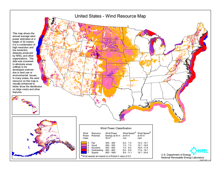
# United States - Wind Resource Map This map shows the annual average wind power estimates at a height of 50 meters. It is a combination of high resolution and low resolution datasets produced by NREL and other organizations. The data was screened to eliminate areas unlikely to be developed onshore due to land use or environmental issues. In many states, the wind resource on this map is visually enhanced to better show the distribution on ridge crests and other features. Wind Power Classification Wind Resource Power Potential Class Wind Speed a Wind Speed a Wind Power at 50 m Density at 50 m at 50 m m/s mph W/m 2 6.4 - 7.0 3 Fair 300 - 400 7.0 - 7.5 4 Good 400 - 500 7.5 - 8.0 5 Excellent 500 - 600 8.0 - 8.8 6 Outstanding 600 - 800 8.8 - 11.1 7 Superb 800 - 1600 a Wind speeds are based on a Weibull k value of 2.0 14.3 - 15.7 15.7 - 16.8 16.8 - 17.9 17.9 - 19.7 19.7 - 24.8 U.S. Department of Energy National Renewable Energy Laboratory 06-MAY-2009 1.1.9 #
