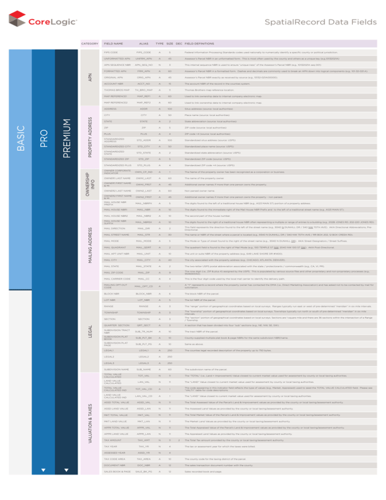
SpatialRecord Data Fields
CATEGORY
field name
apn
FIPS CODE
A
5
UNFORMATTED APN
UNFRM_APN
A
45
APN SEQUENCE NBR
APN_SEQ_NO
N
3
FORMATTED APN
FRM_APN
A
60
Assessor’s Parcel NBR in a formatted form. Dashes and decimals are commonly used to break an APN down into logical components (e.g., 101-32-021.A).
ORIGINAL APN
ORIG_APN
A
45
Assessor’s Parcel NBR exactly as received by source (e.g., 10132-021A00000).
ACCOUNT NBR
ACCT_NO
A
15
The account NBR of the record in the counties system.
TH_BRO_MAP
A
11
Thomas Brothers map reference location.
MAP REFERENCE1
MAP_REF1
A
60
Used to link ownership data to internal company electronic map.
MAP REFERENCE2
MAP_REF2
A
60
Used to link ownership data to internal company electronic map.
ADDR
a
100
Situs addresss (source: local authorities)
CITY
a
50
Place name (source: local authorities)
STATE
a
2
State abbreviation (source: local authorities)
ZIP
a
5
ZIP code (source: local authorities)
PLUS
A
4
ZIP code +4 (source: local authorities)
STD_ADDR
a
100
Standardized situs address (source: USPS)
STD_CITY
a
50
Standardized place name (source: USPS)
STD_STATE
a
2
Standardized state abbreviation (source: USPS)
STD_ZIP
a
5
Standardized ZIP code (source: USPS)
STANDARDIZED PLUS
STD_PLUS
A
4
Standardized ZIP code +4 (source: USPS)
OWNER CORPORATE
INDICATOR
OWN_CP_IND
A
1
The Name of the property owner has been recognized as a corporation or business.
OWNER1 LAST NAME
OWN1_LAST
A
60
The name of the property owner.
OWNER1 FIRST NAME
& MI
OWN1_FRST
A
45
Additional owner names if more than one person owns the property.
OWNER2 LAST NAME
OWN2_LAST
A
60
Non parsed owner name.
ADDRESS
Property Address
STATE
ZIP
PLUS
STANDARDIZED
ADDRESS
STANDARDIZED CITY
STANDARDIZED
STATE
mailing address
ownership
info
STANDARDIZED ZIP
Assessor’s Parcel NBR in an unformatted form. This is most often used by the county and others as a unique key (e.g.,10132021A)
This internal sequence NBR is used to ensure “unique-ness” of the Assessor’s Parcel NBR (e.g., 10132021A seq 001)
OWN2_FRST
A
45
MAIL HOUSE NBR
PREFIX
MAIL_NBRPX
A
5
The digits found to the left of a traditional house NBR (e.g., A123 MAIN ST) portion of a property address.
MAIL HOUSE NBR1
MAIL_NBR
A
10
The digits found to the immediate right of the Mail House NBR Prefix and to the left of a traditional street name (e.g., A123 MAIN ST).
MAIL HOUSE NBR2
MAIL_NBR2
A
10
The second part of the house number.
MAIL HOUSE NBR
SUFFIX
MAIL_NBRSX
A
10
The digits found to the right of a traditional house NBR often representing a multiple or range of entries to a building (e.g., 202B JONES RD, 202-220 JONES RD).
MAIL DIRECTION
MAIL_DIR
A
2
This field represents the direction found to the left of the street name (e.g., 9340 N DUNHILL DR / 340 NW 70TH AVE). AKA Directional Abbreviations, PreDirectional.
MAIL STREET NAME
MAIL_STR
A
30
MAIL MODE
MAIL_MODE
A
5
The Mode or Type of street found to the right of the street name (e.g.., 9340 N DUNHILL DR). AKA Street Designators / Street Suffixes.
MAIL QUADRANT
MAIL_QDRT
A
2
The quadrant field is found to the right of Mail Mode (e.g., 100 TEMPLE ST NW, 2040 NW 100 ST SW). AKA Post-Directional.
MAIL APT UNIT NBR
MAIL_UNIT
A
10
The unit or suite NBR of the property address (e.g., 649 LAKE SHORE DR #1400).
MAIL CITY
Mail_CITY
A
40
The city associated with the property address (e.g., CHICAGO, ATLANTA, DENVER).
Mail_STATE
A
2
The two-letter USPS postal abbreviation associated with the state / protectorants / commonwealth (e.g., CA, VI, PR).
MAIL ZIP CODE
Mail_ZIP
A
9
The nine digit (i.e., ZIP & plus 4) assigned by the USPS. This is populated by various source files and other proprietary and non-proprietary processes (e.g.,
954630042).
MAIL CARRIER CODE
Mail_CC
A
4
This is the four digit code used by the local mail carrier to identify the delivery path.
MAIL_OPT_CD
A
1
A “Y” represents a record where the property owner has contacted the DMA (i.e., Direct Marketing Association) and has asked not to be contacted by mail for
solicitation.
BLOCK_NBR
A
6
The block NBR of the parcel.
LOT_NBR
A
5
The lot NBR of the parcel.
MAILING OPT-OUT
CODE
BLOCK NBR
LOT NBR
Additional owner names if more than one person owns the property - non parsed.
The name or NBR of the street where a parcel is located (e.g., 9340 N DUNHILL DR / 340 NW 70TH AVE / RR BOX 202, 12 BOX CREEK RD).
RANGE
A
3
The “range” portion of geographical coordinates based on local surveys. Ranges typically run east or west of pre-determined “meridian” in six mile intervals.
TOWNSHIP
A
3
The “township” portion of geographical coordinates based on local surveys. Townships typically run north or south of pre-determined “meridian” in six mile
intervals.
SECTION
A
3
The “section” portion of geographical coordinates based on local surveys. Sections are 1 square mile and there are 36 sections within the intersection of a Range
/ Township.
QUARTER SECTION
QRT_SECT
A
3
A section that has been divided into four “sub” sections (e.g., NE, NW, SE, SW).
SUBDIVISION TRACT
NBR
SUB_TR_NUM
A
10
The tract NBR of the parcel.
SUBDIVISION PLAT
BOOK
SUB_PLT_BK
A
10
County-supplied multiple plat book & page NBRs for the same subdivision NBR/name.
SUBDIVISION PLAT
PAGE
SUB_PLT_PG
A
10
Same as above.
LEGAL1
LEGAL1
A
250
LEGAL2
LEGAL2
A
250
LEGAL3
LEGAL3
A
250
RANGE
TOWNSHIP
SECTION
Legal
Federal Information Processing Standards codes used nationally to numerically identify a specific county or political jurisdiction.
OWNER2 FIRST NAME
& MI
MAIL STATE
SUBDIVISION NAME
valuation & taxes
premium
CITY
pro
Type size DEC field definitions
FIPS_CODE
THOMAS BROS MAP
BASIC
alias
The counties legal recorded description of the property up to 750 bytes.
SUB_NAME
A
60
TOTAL VALUE
CALCULATED
The subdivision name of the parcel.
TOT_VAL
N
11
The “TOTAL” (i.e., Land + Improvement) Value closest to current market value used for assessment by county or local taxing authorities.
LAND VALUE
CALCULATED
LAN_VAL
n
11
The “LAND” Value closest to current market value used for assessment by county or local taxing authorities.
TOTAL VALUE
CALCULATED IND
TOT_VAL_CD
A
1
The code appearing in this indicator field reflects the type of values (e.g., Market, Appraised) used to seed the TOTAL VALUE CALCULATED field. Please see
“VALTY” table for code descriptions.
LAND VALUE
CALCULATED IND
LAN_VAL_CD
a
1
The “LAND” Value closest to current market value used for assessment by county or local taxing authorities.
ASSD TOTAL VALUE
ASSd_VAL
N
11
The Total Assessed Value of the Parcel’s Land & Improvement values as provided by the county or local taxing/assessment authority.
ASSD LAND VALUE
ASSd_LAN
n
11
The Assessed Land Values as provided by the county or local taxing/assessment authority.
MKT TOTAL VALUE
MKT_VAL
n
11
The Total Market Value of the Parcel’s Land & Improvement values as provided by the county or local taxing/assessment authority.
MKT LAND VALUE
MKT_LAN
n
11
The Market Land Values as provided by the county or local taxing/assessment authority.
APPR TOTAL VALUE
APPr_VAL
n
11
The Total Appraised Value of the Parcel’s Land & Improvement values as provided by the county or local taxing/assessment authority.
APPR LAND VALUE
APPr_LAN
n
11
TAX_AMT
N
11
TAX_YR
n
4
ASSESSED YEAR
ASSd_YR
n
4
TAX CODE AREA
TAX_AREA
a
10
The county code for the taxing district of the parcel.
DOCUMENT NBR
DOC_NBR
a
12
The sales transaction document number with the county.
SaLe_BK_PG
A
12
Sales recorded book and page.
TAX AMOUNT
TAX YEAR
SALES BOOK & PAGE
The Appraised Land Values as provided by the county or local taxing/assessment authority.
2
The Total Tax amount provided by the county or local taxing/assessment authority.
The tax or assessment year for which the taxes were billed.
CATEGORY
field name
land/property
use & census
See reverse side for
items included in the
BASIC package.
LAND USE
MOBILE HOME IND
PROPERTY
INDICATOR
EFFECTIVE YEAR
BUILT
ACTUAL YEAR BUILT
property
area
structure
value
structure area
rooms
A
10
A FARES established Land Use code converted from various county Land Use codes to aid in search and extract functions.
M_HOME_IND
A
1
This field is populated with a “Y” if a Mobile Home is present on the parcel.
PROP_IND
A
3
A FARES general code used to easily recognize specific property types (e.g., Residential, Condominium, Commercial).
EFf_YR_BLT
N
4
This is the first year the building was assessed with its current components (e.g., a building is originally constructed in 1960 and a bedroom and bath was added to
the building in 1974. The Year Built would be 1960 and the Effective Year Built would be 1974.
N
4
This is the construction year of the original building.
A
10
Comprised of Census Tract, Census Block and Census Block Suffix. These NBRs are established by the US Department of Commerce (Bureau Of The Census).
ZONING
A
15
The data contained in this field is based upon County and/or Local established Zoning Codes and are not converted by CoreLogic.
FRONT FOOTAGE
FroNT_FT
n
7
4
The linear feet across the front of the lot - facing the street.
DEPTH FOOTAGE
DepTH_FT
n
7
4
The linear feet between the front and back of the lot.
ACRES
land_ACRES
N
9
4
Total land mass in Acres.
LAND SQUARE
FOOTAGE
Land_SQ_FT
N
9
LOT AREA (ALPHA)
LOT_AREA
A
20
ASSD IMPROVEMENT
VALUE
ASSd_IMP
n
11
The Assessed Improvement Values as provided by the county or local taxing/assessment authority.
MKT IMPROVEMENT
VALUE
Total land mass is Square Feet.
Land dimension text.
MKT_IMP
n
11
The Market Improvement Values as provided by the county or local taxing/assessment authority.
APPR IMPROVEMENT
VALUE
APPr_IMP
N
11
The Appraised Improvement Values as provided by the county or local taxing/assessment authority.
IMPROVEMENT
VALUE CALCULATED
IMP_VaL
n
11
The “IMPROVEMENT” Value closest to current market value used for assessment by county or local taxing authorities.
UNIVERSAL BUILDING
SQUARE FEET
UBLD_SQ_FT
n
9
The Building Square Footage that can most accurately be used for assessments or comparables (e.g., Living, Adjusted, Gross).
BUILDING SQUARE
FEET IND
BLD_SQ_IND
A
1
The codes appearing in this field indicates the source used to populate the UNIVERSAL BUILDING SQUARE FEET field (e.g., Living, Adjusted, Gross).
Please see “BLDSF” table for code descriptions.
BUILDING SQUARE
FEET
BLD_SQ_FT
n
9
The size of the building in Square Feet. This field is most commonly populated as a cumulative total when a county does not differentiate between Living and Non-living
areas.
LIVING SQUARE FEET
LiV_SQ_FT
n
7
2
This is the area of a building that is used for general living. This is typically the area of a building that is heated or air conditioned and does not include Garage,
Porch or Basement square footage.
GROUND FLOOR
SQUARE FEET
GF_SQ_FT
n
7
2
Square footage of the part of the building which is level with he ground (typically the front of the building). This is generally above the basement(s) and below the
second floor.
GROSS SQUARE FEET
GR_SQ_FT
n
7
2
This is the square footage for the entire building. Typically this represents all square feet under the roof.
ADJUSTED GROSS
SQUARE FEET
ADJ_SQ_FT
n
7
2
This is the square footage used by the county or local taxing/assessment authority to determine Improvement Value. This figure is typically 100% of the living
area, plus lower percentage of non-living area.
BSMT_SQ_FT
n
7
2
This is total square footage associated with Basement portion of a building. This would include both finished and unfinished areas.
GARAGE/PARKING
SQUARE FEET
Pkg_SQ_FT
n
7
2
This is the total square footage of the primary garage or parking area (i.e., commercial). This includes both finished and unfinished areas.
BEDROOMS
BEDROOMS
n
5
Total NBR of bedroom contained in the primary building.
TOTAL ROOMS
ROOMS
n
5
Total NBR of rooms contained in the primary building.
TOTAL BATH
CALCULATED
BATHS_CAL
n
5
2
Total NBR of Bath Rooms in whole NBRs (e.g., a home containing 2 1/2 baths would have the NBR 3 stored in this field as, three actual rooms have been
designated for this purpose).
2
Total NBR of Bathrooms as provided by our data sources (e.g., 4.00, 2.50, 1.75).
BATHS
n
5
FULL BATHS
FULL_BATHs
n
5
Total NBR of Full Baths (typically comprised of a sink, toilet, and bathtub / shower stall). A home containing 2 1/2 baths would have the NBR 2 stored in this field.
HALF BATHS
HALF_BATHs
n
5
Total NBR of Half Baths (typically comprised of a sink & toilet). A home containing 2 1/2 baths would have the NBR 1 stored in this field.
1QTR BATHS
QTR1_BATHS
n
5
Total NBR of Quarter Baths (typically comprised only of a sink, as found in many laundry rooms).
3QTR BATHS
QTR3_BATHS
n
5
Total NBR of 3 Quarter Baths (typically comprised of a sink, toilet & shower stall).
BATH FIXTURES
BaTH_FIX
n
5
The total NBR of bathroom fixture (typically a Full Bath would have 4 fixtures - 1 = sink, 1 = toilet, 1 = bathtub, 1 = shower head).
AIR CONDITIONING
AIR_COND
A
3
The type of air conditioning method used to cool the building (e.g., Central, Wall Unit, Evaporative). Please see “AC” table for code descriptions.
BASEMENT FINISH
BSMT_FNSH
A
3
The type of basement found in the building (e.g., Finished, Half, Crawl). Please see “BSMTF” table for code descriptions.
BLDG CODE
BLD_CODE
A
3
The primary building type (e.g., Bowling Alley, Supermarket). Please see “BLDG” table for code descriptions.
BLD_IMP_CD
A
3
The primary improvement type (e.g., Grain Silo, Hanger, Marina). Please see “IMPRV” table for code descriptions.
CONDITION
A
3
This represent the physical condition of the mail improvement (e.g., Good, Fair, Under Construction). Please see “COND” table for code descriptions.
CONSTR_TYP
A
3
The primary method of construction (e.g., Steel/Glass, Concrete Block, Log). Please see “CNSTR” table for code descriptions.
EXT_WALLS
A
3
The type and/or finish of the exterior walls (e.g., Vinyl Siding, Brick Veneer, Frame/Stone). Please see “EXTNW” table for code descriptions.
FIREPLACE IND
FRPLCE_IND
A
1
This field is populated with a “Y” if a fireplace is located within the building.
FIREPLACE NBR
FRPLCE_NBR
n
3
This represent the NBR of fireplace openings located within the building
FIREPLACE TYPE
FRPLCE_TYp
A
3
The type of fireplace (e.g., 2 Story/3 Openings, 2 Story Brick). Please see “FIREP” table for code descriptions.
FOUNDATION
FOUNDATION
A
3
The type of foundation (e.g., Continuous Footing, Pier, Mud Sill). Please see “FOUND” table for code descriptions.
FLOOR
FLOOR
A
3
The type of floor construction (e.g., Concrete, Plywood). Please see “FLTYP” table for code descriptions.
FRAME
FRAME
A
3
The type of roof framing used (e.g., Bar Joist, Reinforced Concrete, Flexicore). Please see “RFFRM” table for code descriptions.
GARAGE
A
3
Type of garage or carport present (e.g., Attached Finished, Enclosed Carport, Basement Garage). Please see “GNPCO” table for code descriptions.
TOTAL BATHS
BLDG IMPV CODE
CONDITION
CONSTRUCTION TYPE
EXTERIOR WALLS
construction
LAND_USE
YR_BLT
BASEMENT SQUARE
FEET
GARAGE
HEATING
A
3
Type or method of heating (e.g., Hot Water, Heat Pump, Baseboard, Radiant). Please see “HEAT” table for code descriptions.
PKG_SPACES
n
5
This represent the total NBR of Parking Spaces or Car Capacity associated with the Garage or Parking type.
PKG_TYP
A
3
Type of parking found on the parcel. This is typically commercial or communal (e.g., Condos) in nature. Please see “PARKG” table for code descriptions.
POOL
A
1
This field is populated with a “Y” if a Pool is present on the parcel
POOL CODE
POOL_Cd
A
3
Type of pool, construction or pool amenities (e.g., Kidney, Gunite, Vinyl, Jacuzzi, Heated). Please see “POOL” table for code descriptions.
QUALITY
QUALITY
A
3
Type of construction quality of building (e.g., excellent, economical). Please see “QUAL” table for code descriptions.
ROOF_COVER
A
3
Type of roof covering (e.g., Clay Tile, Aluminum, Shake). Please see “RFCOV” table for code descriptions.
ROOF TYPE
ROOF_TYP
A
3
Type of roof shape (e.g., Gambrel, Gable, Flat, Mansard). Please see “RFSHP” table for code descriptions.
STORIES CODE
STORY_CD
a
3
Type / NBR of stories (e.g., Split Foyer, Tri Level, 2 Story). Please see “STORY” table for code descriptions.
STORY_NBR
N
3
BLD_VIEW
A
3
View from building (e.g., Gulf, Mountains, Pool). Please see “VIEW” table for code descriptions.
LOC_INF
a
3
Positive or negative aspects associated with the location of the parcel (e.g., waterfront, flood plane, airport). Please see “LOCIN” table for code descriptions.
NBR OF UNITS
BLD_UNITS
n
3
Total number of buildings on the parcel.
UNITS NUMBER
UNITS_NBR
n
5
Number of Residential, Apartment or Business Units.
ENERGY_USE
a
3
Type of electricity or energy use within the building (e.g., Average Wiring, Underground Wired, Private Source). Please see “ELEC” table for code descriptions.
HEATING
PARKING SPACES
PARKING TYPE
POOL IND
ROOF COVER
STORIES NBR
VIEW
LOCATION
INFLUENCE
ELECTRIC/ENERGY
utilities
Type size DEC field definitions
CENSUS_TR
CENSUS TRACT
ZONING
premium
alias
FUEL
2
NBR of stories associated with the building (e.g., 2, 1.5).
FUEL
a
3
Type of fuel used for heating of water and building (e.g., Solar, Gas, Oil). Please see “FUEL” table for code descriptions.
SEWER
SEWER
a
3
Type of sewer system on the parcel (e.g., Public, Septic, Commercial). Please see “SEWER” table for code descriptions.
WATER
WATER
a
3
Type of water service on the parcel (e.g., Public, Well, Cistern). Please see “WATER” table for code descriptions.
FOR MORE INFORMATION, PLEASE CALL 855-267-7027
OR VISIT corelogic.com/spatialrecord
© 2014 CoreLogic, Inc. All rights reserved.
CORELOGIC and the CoreLogic logo are trademarks of CoreLogic, Inc. and/or its subsidiaries.
1-SROI-1411-01
corelogic.com

