Practicing Planner — Summer 2014 — Planning Practice Special Feature
Planning at Stanford University: The General Use Permit
by Scott Lefaver, AICP
The year is 2000 and Stanford University is feeling the pressures for expansion and possible rapid
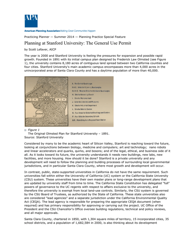
growth. Founded in 1891 with its initial campus plan designed by Frederick Law Olmsted (see Figure
1), the university contains 8,180 acres of contiguous land spread between two California counties and
four cities. Stanford University's main academic campus encompasses more than 4,000 acres in the
unincorporated area of Santa Clara County and has a daytime population of more than 40,000.
Figure 1
The Original Olmsted Plan for Stanford University – 1891.
Source: Stanford University
Considered by many to be the academic heart of Silicon Valley, Stanford is reaching toward the future,
looking at conjunctions between biology, medicine and computers; art and technology; nano robots
and linear accelerators and quarks, quirks, and bosons; and of the legal, ethical, and business side of it
all. As it looks toward its future, the university understands it needs new buildings, new labs, new
facilities, and more housing. How should it be done? Stanford is a private university and any
development will need to follow the planning and building processes of surrounding local governmental
jurisdictions, and in particular Santa Clara County, where most growth and development will occur.
In contrast, public, state-supported universities in California do not have the same requirement. Such
universities fall within either the University of California (UC) system or the California State University
(CSU) system. These universities have their own master plans or long-range development plans that
are updated by university staff from time to time. The California State Constitution has delegated "full"
powers of governance to the UC regents with respect to affairs exclusive to the university, and
therefore the university is exempt from local land-use controls. Similarly, the CSU system is governed
by the CSU Board of Trustees, as authorized by the State of California. These state universities also
are considered "lead agencies" and a separate jurisdiction under the California Environmental Quality
Act (CEQA). The lead agency is responsible for preparing the appropriate CEQA document (when
required) and has primary responsibility for approving or carrying out the project. UC Office of the
President and the CSU Chancellor's Office oversee building regulations, technical and policy reviews,
and all major approvals.
Santa Clara County, chartered in 1850, with 1,304 square miles of territory, 15 incorporated cities, 35
school districts, and a population of 1,682,584 in 2000, is also thinking about its development
processes. In 1976, the county, in agreement with its incorporated cities, opted out of the urban
development business. No urban development would take place within the unincorporated areas of the
county. All housing subdivisions, major shopping centers, and urban infrastructure would take place in
cities. Land would be annexed and incorporated first before being developed. There were still
unincorporated pockets of urban development within the county: San Martin, Burbank, and Monte
Vista. These areas were considered small, almost rustic, suburban communities overlooked by adjacent
cities for annexation or whose community members did not want to annex to those cities. Then there's
Stanford University, a virtual city unto itself; a dynamic hotspot where development would take place
as the demand for growth presented itself. What should the county do?
The land-use and development agreement between Stanford and the county, signed in 1989, needed
updating. The gross square footage of development and population caps had been reached. The 1989
agreement was fashioned along the normal lines of the development process and included a land-use
plan and basic zoning. Before development took place, each building would go through a land-use,
architectural, design, and environmental review. There was a linear permitting process, where one
item would be approved before another was undertaken. It was slow, cumbersome, and expensive.
Coordination between the land uses and future development seemed disconnected. The pieces were
not fitting together.
In late 1999 and early 2000, officials from the county and the university — along with members of the
community — met and together sketched out another way to review and process the projected
development on the campus. All participating parties wanted both a solid planning document laying out
basic policy parameters, land uses, and environmental reviews for the Stanford community, as well as
a method by which development could go forward with the process focused at the design and
architectural level. Local communities, particularly Palo Alto and Menlo Park, were concerned the
booming growth in Silicon Valley and the continuing growth of Stanford would be detrimental to their
local interests. These communities were facing shortages of affordable rental housing, continuous
traffic jams, and a perceived deterioration of the open space and environment around them.
In the spring of 2000, Santa Clara County, Stanford University, and the local governments around
Stanford concluded that the best approach would be to approve an overall, long-term, campus plan
together with environmental documents anticipating development. Once adopted, the rules for
development would be set, benchmarks placed, processes clearly understood and streamlined. Any
additional development not part of the plan would go through the more traditional land-use approval
process with a single project focus. This approach is also in keeping with the requirement under CEQA
to evaluate the "who of the action" at the earliest possible stage in planning.
Three documents were initially produced: The Stanford University Community Plan, the General Use
Permit (GUP) and the Environmental Impact Report covering both the Community Plan and General
Use Permit. In the years following these approvals, other reports and plans were produced to comply
with the requirements of the GUP, including a Sustainable Development Study (2008), a Habitat
Conservation Plan (2012), and an annual report to the Santa Clara County Planning Commission
reviewing development compliance and environmental mitigations.
The Stanford University Community Plan
The community plan is a policy plan that amends Santa Clara County's General Plan as it applies to
lands owned by Stanford University within the unincorporated area of the county. It guides future uses
and development and is adopted as part of the county's general plan in accordance with California
state law. This is in contrast to a more rigid approach of a specific plan, which must conform to
California state law criteria, guidelines, and standards and is adopted as a separate document from the
general plan.
The community plan contains seven chapters that relate to the seven basic elements of the county's
General Plan: growth and development, land use, open space, housing, circulation, resource
conservation, and health and safety. It focuses on the following:
z
z
Promoting compact development and conservation of natural resources.
Allowing flexibility of development within a framework that minimizes potential negative effects.
z
z
z
z
z
Accommodating development for academic uses and housing on lands within an established
growth boundary (called the Academic Grow Boundary or AGB) and limiting development and
promoting conservation outside that boundary.
Differentiating major land uses within the community plan and specifying areas for academic
uses, housing for faculty/staff, and open space.
Developing new faculty/staff and student housing concurrent with the increase in academic
space.
Minimizing commuter trips through a variety of means, including an increase in transit services,
transportation demand management, and the mixing and combining of land uses.
Emphasizing preventative measures or avoidance of impacts while achieving conservation,
public health, and safety goals.
These policies establish the heart of the university's growth and development program within the
context of the general use permit.
The General Use Permit (GUP)
A use permit allows development of land uses when specified conditions are met. Both the uses and
the conditions are spelled out in the permit. These types of permits usually apply to a single use or
parcel of land. Santa Clara County and Stanford expanded the idea of the use permit to cover all
Stanford lands located within the unincorporated area. This single permit would control type of
development, location, and amount of square footage under construction. It would tie the
developments together in terms of types of uses, precedence (i.e., what comes first, what must be
built at the same time, what comes afterward), and time periods. Within the plan this relationship
among land uses is called "linkage." Further, after a set amount of square footage is built for academic
space, there will be a set amount of square footage for student and faculty housing built before more
academic space is allowed to be developed.
The Stanford GUP is different from conventional use permits not only because of its large scope, but
also the way in which it is applied. The GUP has no time limit but is applicable until certain amounts of
building square footage and housing units are constructed. This includes:
z
z
z
z
z
z
z
z
z
Construction of up to 2,035,000 net square feet of new academic and academic support uses.
Construction of 2,000 net new student housing units.
Construction of 350 net new housing units for postdoctoral fellows and medical residents.
Construction of 668 net new housing units for faculty and staff.
Construction of no more than 2,300 net new parking spaces above the current campus base of
19,351 spaces.
No net increase in vehicle trips on to campus during peak hours.
Continuation of all lawful existing uses in their present locations, including legal nonconforming
uses.
Any building area allocated from the 1989 General Use Permit and not built is not counted in the
new construction allocations of the updated GUP. After review, it can proceed with construction.
Nonacademic building areas that have independent caps from academic buildings (those
buildings associated with university education) include a child care/community center, parking
structures, and residential housing for other than those mentioned above.
The GUP covered not only building and construction of the campus but went into detail of where
academic building would take place, where student and faculty housing would be built, what
transportation and parking improvements would be required and where they would be located, and
what parks and recreation facilities (mainly focused on trails in the undeveloped areas) would be
improved. Uses were allocated by generalized districts, such as the campus area with designated areas
for the arts, engineering, business, and science; the Medical Center, the SLAC National Acceleration
Laboratory, and the Jasper Ridge Biological Preserve. Figure 2, the Stanford Plan, illustrates the
location of these various uses and the governmental jurisdictions they lie within.
Figure 2
Stanford Planning Zones
Environmental Impact Review (EIR)
The university's overall proposed development was reviewed under a Program Environmental Impact
Report (EIR), which measured the impacts, suggested mitigations, and provided for monitoring. Under
California law, Program EIRs are prepared on a series of actions that are characterized as one large
project and are:
z
z
z
Related geographically;
Logical parts of a chain of actions; and
Undertaken as part of the issuance of rules, regulations, or plans.
Once the Program EIR is certified, subsequent projects consistent with the approved proposed
development (including later site-specific approvals) can rely on the analysis contained in this EIR.
Subsequent activities in the program must be examined in light of the Program EIR to determine
whether an additional environmental document must be prepared. If no new significant effects could
occur or no new mitigation measures would be required, the agency can approve the activity as being
within the scope of the project covered by the Program EIR and no new CEQA document would be
required. Those thresholds are prescribed within the GUP conditions.
Mitigation measures and monitoring required by the EIR are included in the GUP. There are a number
of measures that focus on planning and design, construction and operations, and maintenance. They
include traffic measures that result in no net increase of commute trips. The university also wants to
maintain a no net increase in energy use, even as the university grows, and wants to implement
programs to reduce water use by between 6 percent and 10 percent from its 2000 levels. Sensitive
habitats have preservation easements placed upon them and special, comprehensive protection
programs are being pursued to preserve endangered species, such as the Tiger Salamander.
To manage the 110 GUP conditions, the county formed a post approval monitoring team within the
planning department to ensure continuous compliance with the project requirements. An annual report
is prepared that documents compliance with the GUP conditions.
Why the General Use Permit Is a Success
The GUP approach used best planning practices by taking comprehensive planning and combining it
with the practical aspects of development within an open-ended time period. It is planning and
development based on performance. Instead of using time lines or specific types of building uses or
zoning or individual use permits for each building or area of development (such as in a specific plan),
the GUP combines many development factors as keys for implementation: square footages of certain
building types and uses; circulation improvements tied to that construction, and environmental
programs that must be implemented at the same time. The permit approach gave Stanford a clear,
known path of how and where to build and under what conditions. It is the amount of building and
construction along with the circulation and environmental programs that determine when the project is
complete and when Stanford can apply for additional development permits. It is the overall package
and understanding that implementation is tied with planning that makes this approach a success. It is
performance planning at its best.
There is yet another reason why the GUP works well: the approach by Santa Clara County and
Stanford was more of a public-private development partnership than a regulator-versus-developer
relationship.
Annual Report No. 12
In June 2013, Santa Clara County published Annual Report Number 12, which outlined the progress of
development at Stanford University through August 2012. The growth has been remarkable:
z
z
z
1,224,892 square feet of buildings approved and permitted (See Figure 3 for an example of
building)
56,692 square feet approved by the county's architectural and site approval committee, waiting
for building permit
1,457 new housing units approved (mainly for students)
Yet with all this growth, the number of parking spaces diminished by 236. Automobile traffic has been
kept within its baseline of no net increase in commuter trips. Water use fell and is in keeping with
Stanford's goal of reducingwater usage between 6 percent and 10 percent from the year 2000
baseline. The campus is allocated 3.033 million gallons a day (mgd) from the water district, and
Stanford's domestic water use for last year was 2.16 mgd. By capping the amount of new square
footage to be built, Stanford reconstructed and reused older buildings, upgrading them to meet today's
needs. Of the 110 GUP conditions and compliance items, all were followed by Stanford. Santa Clara
County's planning staff presented a very positive report to the County Planning Commission at its June
2013 meeting.
Figure 3
John A. and Cynthia Fry Gunn Building, completed 2010.
Source: Stanford University
The Success Continues
Determination by both Stanford University and the county to bring about success by creating different,
acceptable, and collaborative ways to develop is the key to this successful undertaking. Using basic
land-use practices and approval procedures but putting them into a non-linear and non-time
constrained, performance-based approval made all the difference. Yes, it helped that there were only
two major corporate entities negotiating with each other, but the lessons are very clear. Large chunks
of development can take place and high standards for land-use and environmental protection can be
met when performance is the driver. The GUP has proven to be a better method than the alternative —
using a linear approval process for each individual parcel of land needing specific land-use/zoning
requirements, with specific time constraints.
Scott Lefaver, AICP, is chair of the Santa Clara County Planning Commission and a board member of
the California County Planning Commissioners Association.
©Copyright 2014 American Planning Association All Rights Reserved


