El Niño, La Niña and Climate Impacts on Agriculture
advertisement
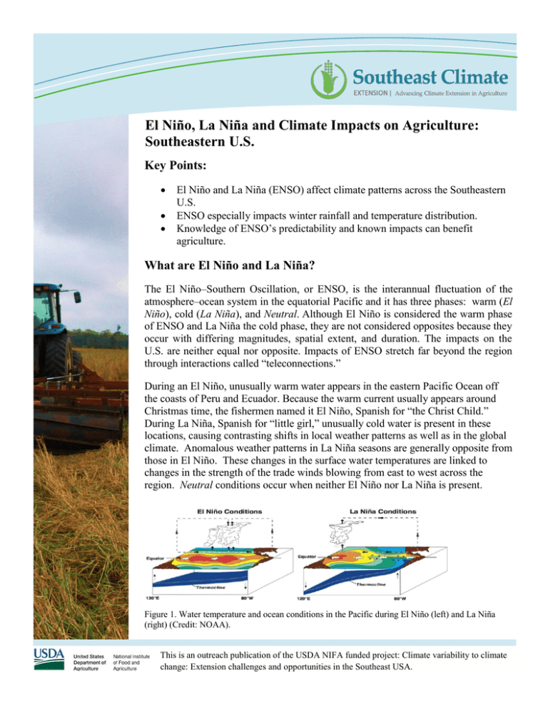
El Niño, La Niña and Climate Impacts on Agriculture: Southeastern U.S. Key Points: El Niño and La Niña (ENSO) affect climate patterns across the Southeastern U.S. ENSO especially impacts winter rainfall and temperature distribution. Knowledge of ENSO’s predictability and known impacts can benefit agriculture. What are El Niño and La Niña? The El Niño–Southern Oscillation, or ENSO, is the interannual fluctuation of the atmosphere–ocean system in the equatorial Pacific and it has three phases: warm (El Niño), cold (La Niña), and Neutral. Although El Niño is considered the warm phase of ENSO and La Niña the cold phase, they are not considered opposites because they occur with differing magnitudes, spatial extent, and duration. The impacts on the U.S. are neither equal nor opposite. Impacts of ENSO stretch far beyond the region through interactions called “teleconnections.” During an El Niño, unusually warm water appears in the eastern Pacific Ocean off the coasts of Peru and Ecuador. Because the warm current usually appears around Christmas time, the fishermen named it El Niño, Spanish for “the Christ Child.” During La Niña, Spanish for “little girl,” unusually cold water is present in these locations, causing contrasting shifts in local weather patterns as well as in the global climate. Anomalous weather patterns in La Niña seasons are generally opposite from those in El Niño. These changes in the surface water temperatures are linked to changes in the strength of the trade winds blowing from east to west across the region. Neutral conditions occur when neither El Niño nor La Niña is present. Figure 1. Water temperature and ocean conditions in the Pacific during El Niño (left) and La Niña (right) (Credit: NOAA). This is an outreach publication of the USDA NIFA funded project: Climate variability to climate change: Extension challenges and opportunities in the Southeast USA. El Niños and La Niñas occur semi-regularly at intervals of 2-5 years, and usually last from 9 to 12 months. The large pools of warm or cold water produced in these events change atmospheric pressure patterns in the tropical Pacific region and global wind patterns far from the tropics. This leads to statistically observable changes in temperature and rainfall patterns that vary by ENSO phase in many areas of the world. Characteristics of ENSO Phases El Niño Figure 2. Warm (W), dry (D) and rainy (R) patterns in an El Niño Northern Hemisphere winter (Credit: NOAA). How are El Niño and La Niña Detected and Predicted? Ocean temperatures of 4-6 ˚F above average are commonly observed between the International Dateline and the west coast of South America. Warm ocean waters cause increases in tropical rain and thunderstorms. Atmospheric pressure increases near Indonesia and in the western Pacific and decreases in the eastern Pacific. Pressure changes lead to the subtropical jet stream moving into Florida, southern Georgia, and Alabama, steering cloudy, rain-bearing systems into the region in winter. Because of changes in jet stream strength, hurricanes are less likely. El Niño lasts for no more than one year. The likelihood of tornadoes and severe weather increases in the Florida peninsula. La Niña A number of international science agencies work cooperatively to monitor the ENSO system. They use the data they collect to calculate indexes such as the Southern Oscillation Index, Nino3.4, and the Multivariate ENSO Index, which characterize the strength of each ENSO episode. Statistical and dynamical computer models are used to predict how the ENSO will change over time. These predictions can tell us up to several months ahead what variations in climate to expect. They allow scientists to anticipate what impacts will occur over the months that follow the onset of one of these events. Figure 3. El Niño (red) and La Niña (blue) occurrence from 1950 to the present (Credit: NOAA). Ocean temperatures of 4-6 ˚F below average are observed in the eastern Pacific Ocean. Cold water in the eastern Pacific shifts the location of thunderstorms, rising air, and lower pressure to the western Pacific. Cold water from the deep ocean provides increased nutrients for fish and plankton, leading to improved fishing and to sustenance for birds and other predators in the eastern Pacific Ocean. Pressure shifts cause the subtropical jet stream in the U.S. to shift north, moving the storm track to northern Georgia and Alabama and leaving Florida sunnier and drier than usual. La Niña can last for one to three years. The likelihood of tornadoes and severe weather increases in Alabama and Georgia. El Niño Temperature and Precipitation Anomalies La Niña Temperature and Precipitation Anomalies Rainfall (inches), difference from average Temperature (⁰F), difference from average La Niña Impacts on the Southeast by Season El Niño Impacts on the Southeast by Season Peninsular FL Tri-State Region Western Panhandle OctDec Wet & cool Wet No impact JanMar Very wet & cool Wet AprJun Slightly dry JulSept Slightly dry to no impact Peninsular FL Tri-State Region Western Panhandle Slightly dry Slightly dry JanMar Dry & slightly warm Very dry & warm Dry Dry No impact AprJun Slightly wet Dry Dry No impact JulSept Slightly cool No impact No impact Central and North AL and GA No impact Eastern NC Likely wet OctDec Wet No impact Likely wet Slightly wet Slightly dry No impact No impact No impact Slightly dry Central and North AL and GA Dry Eastern NC Dry in south, wet in NW AL No impact Likely dry Wet in NW AL No impact Likely dry No impact ENSO Impacts on Southeastern Agriculture During La Niña Years During El Niño Years Irrigated corn yields are generally higher. Reduction in yield (up to 12 percent) may be expected in the years following La Niña. Harvests of summer crops such as corn, peanuts, and cotton may be delayed because of increased rains in the fall. Planting of non-irrigated corn should be delayed until May to match summer rainfall with pollination and silking stages. Frequent rains may reduce tilling and yield of winter wheat. Wheat yields in northern AL are generally higher than average during La Niña. Wheat yields in southern AL and GA are generally higher than average during El Niño. Frequent rains at the end of August and in early September may increase Hessian fly populations on winter wheat. Warm winter and spring might result in faster development and higher populations of Hessian flies and aphids may put wheat at higher risk. Intensity of tomato spotted wilt virus is lower. Winter tomato and green pepper yields are expected to be higher. Less fungal and bacterial disease in winter vegetables may be expected. However, virus spread by thrips, such as tomato spotted wilt, and white fly, such as tomato yellow leaf curl, can be a major problem Corn yields are usually lower than historic averages. Susceptible and moderate peanut cultivars have higher intensity of tomato spotted wilt virus. Yields of winter vegetables such as tomatoes, bell peppers, sweet corn, and snap beans are lower. Fungal and bacterial diseases, especially bacterial spot of tomato and bell peppers, present higher risks. Winter pasture crops may benefit from wetter weather, but planting and harvesting operations may be affected by heavy rainfall. Pasture crops exhibit lower yields. For example, reduction in ryegrass yield up to 40 percent may be expected. Growers may need to increase the number of dormancy-compensating sprays to temperature fruits because of decreased chill accumulation. The population of annual broadleaf weeds, which are the host for sucking bugs that attack peaches, might increase. Flowering of subtropical fruits, such as mango, lychee, and longan, may decrease or be eliminated, but production of tropical fruits such as banana, guava and papaya may increase. The disease problem is lower, but insect pressure may increase. Growers may have to reduce the dormancycompensating sprays to temperature fruits, such as peach, nectarine, blueberry, and strawberry because of increases in chill accumulation. Strawberry growth is slower than normal. Risk of fungal diseases such as anthracnose, botrytis fruit rot, and angular leaf spot is higher. Resources: Tools: Management: Climate Impacts: ENSO overview: http://www.agroclimate.org/tools.php http://agroclimate.org/fact-sheets-management.php http://www.cpc.ncep.noaa.gov/products/precip/CWlink/ENSO/composites/ http://www.cpc.ncep.noaa.gov/products/precip/CWlink/MJO/enso.shtml Authors: Pam Knox, Agricultural Climatologist, Crop and Soil Sciences Dept., University of Georgia Melissa Griffin, Assistant State Climatologist, COAPS, Florida State University. The section ‘ENSO Impacts on Southeastern Agriculture’ was originally published in “The ABC’s of Climate Variability” by Reshmi Sarkar and Brenda Ortiz, Alabama Cooperative Extension System.
