The Nile on the move - Egypt Exploration Society
advertisement

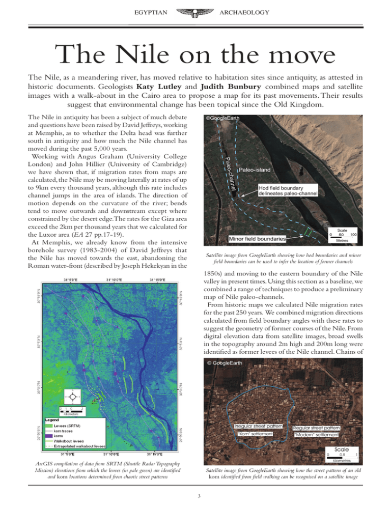
EGYPTIAN ARCHAEOLOGY The Nile on the move The Nile, as a meandering river, has moved relative to habitation sites since antiquity, as attested in historic documents. Geologists Katy Lutley and Judith Bunbury combined maps and satellite images with a walk-about in the Cairo area to propose a map for its past movements. Their results suggest that environmental change has been topical since the Old Kingdom. The Nile in antiquity has been a subject of much debate and questions have been raised by David Jeffreys, working at Memphis, as to whether the Delta head was further south in antiquity and how much the Nile channel has moved during the past 5,000 years. Working with Angus Graham (University College London) and John Hillier (University of Cambridge) we have shown that, if migration rates from maps are calculated, the Nile may be moving laterally at rates of up to 9km every thousand years, although this rate includes channel jumps in the area of islands. The direction of motion depends on the curvature of the river; bends tend to move outwards and downstream except where constrained by the desert edge.The rates for the Giza area exceed the 2km per thousand years that we calculated for the Luxor area (EA 27 pp.17-19). At Memphis, we already know from the intensive borehole survey (1983-2004) of David Jeffreys that the Nile has moved towards the east, abandoning the Roman water-front (described by Joseph Hekekyan in the ©GoogleEarth Satellite image from GoogleEarth showing how hod boundaries and minor field boundaries can be used to infer the location of former channels 1850s) and moving to the eastern boundary of the Nile valley in present times. Using this section as a baseline, we combined a range of techniques to produce a preliminary map of Nile paleo-channels. From historic maps we calculated Nile migration rates for the past 250 years. We combined migration directions calculated from field boundary angles with these rates to suggest the geometry of former courses of the Nile. From digital elevation data from satellite images, broad swells in the topography around 2m high and 200m long were identified as former levees of the Nile channel. Chains of © GoogleEarth ArcGIS compilation of data from SRTM (Shuttle Radar Topography Mission) elevations from which the levees (in pale green) are identified and kom locations determined from chaotic street patterns Satellite image from GoogleEarth showing how the street pattern of an old kom identified from field walking can be recognised on a satellite image EGYPTIAN ARCHAEOLOGY Sieving sediment at the ‘Lost City of the Pyramids’. Photograph: Katy Lutley was further south in the past. A more southerly ancient Delta head, in the absence of tectonic uplift or sea-level fall with time, suggests that the Nile in antiquity had a higher flow rate which is supported by the suggestions of Bell (1975), Butzer (1976) and Hassan (2003, 2004) that the flow-rate and river plan-form were larger in antiquity. Distributaries in a delta form in such a way that none of the river-beds has a base below sea-level. In the case of the Nile, a higher flow rate in antiquity ensured that the Delta head was further south and that there were more numerous distributaries. Historical sources such as Herodotus and Strabo support the view that there were many more distributaries in antiquity. Our map suggests that an active Nile had an impact on the development of the site of the pyramids at Giza. We propose that a branch of the Nile was located to the far west of the valley prior to the building of these pyramids. By the time of the completion of the causeway to the Khufu pyramid (mapped by Mark Lehner), it must already have moved away from this extreme western location. It is interesting to speculate whether the blocks quarried for the Khufu pyramid created the embayment in the river-bank that was later used as a harbour as shown by the Giza project.That the river rapidly moved away from Results of theoretical calculations of migration rates over the past 250 years extrapolated to demonstrate that the Nile is expected to have crossed the entire floodplain over the past 5,000 years koms, field and hod boundaries and patterns of topographic contours on maps further defined the locations of former levees and direction of migration of the river. In collaboration with Mark Lehner and his team at Giza we conducted a walking survey of koms, former levees and basin divides in the Giza area. The Bahr el-Libeini and the Mansouriya canal seem to follow the patterns of the former levees, the most westerly of which is visible beneath the surface in Glen Dash’s geophysical survey in Aeragram (www.aeraweb.org/aeragram.asp). We also traced the feature above ground through the green of the second hole of the Mena House Golf Course at Giza and as far as the riding stables east of the ‘Lost City of the Pyramids’ (Grid reference: 29o 58′17.12″ N, 31o 08′ 36.87″ E). These observations place constraints on the geometry of the movement of the Nile but they do not provide time constraints. Migration of the river destroys all the settlement on the erosional side of the river and preserves only sites on the depositional side. By linking the geometry to the ages of known sites within the Nile valley, we can determine the time before which the river last passed a certain point. We combined these results to plot a map for Nile position over the past 5,000 years. In line with the results obtained by other researchers such as David Jeffreys, the migration geometry and rates suggest that the Delta head The Mena House Hotel golf course at Giza with earthworks that remain from the relict river levee. Photograph: Katy Lutley EGYPTIAN ARCHAEOLOGY this location was a product of its natural migration, but did waste from the pyramid builders’ quarry enhance deposition and force the river eastwards? Once the process of migration away from the site began, it seems to have continued. At what point there ceased to be more than one branch of the Nile at this latitude (one of the others passing by Heliopolis) has yet to be determined. The ‘trapping’ of the river by the revetment of the waterfront at Babylon and the limiting of migration by human activity have prevented more rapid migration back towards the west. Thus, at Giza, Khufu had the advantage of a river adjacent to the plateau edge with a water connection through a more southerly Delta head to the quarries for the Tura limestone. By the time Menkaure began construction at his chosen site, he was struggling against the elements. His pyramid site was further west from the plateau edge and the river further east. The logistics of transport for the granite pyramid casing were complex and, due to natural processes of river migration, increasingly difficult with time. Is this why the pyramid remained unfinished at his demise? Our results may also have some bearing on why the site of the capital of Egypt has moved so much between Memphis, Babylon, el-Fustat, Cairo, Heliopolis and other sites.With the river snaking across the valley and the Delta head migrating northwards and losing branches with time, some settlements, like that at Giza, were simply left high and dry. The pragmatic response to the environmental change was to found a new settlement that took advantage of the prevailing conditions. Two silt deposits at the ‘Lost City of the Pyramids’. The upper silt has much finer particles than the lower, suggestive of a greater distance to the river. The upper silt is 10-20cm thick. Photograph: Katy Lutley River flood-plain silt deposits that seal the site of the ‘Lost City of the Pyramids’. Photograph: Angus Graham Elevated road-way at Giza. Part of the relict river levee. Photograph: Angus Graham Final map showing best fit estimate of ancient river positions from all sources of information q Katy Lutley (St John’s College) and Judith Bunbury (St Edmund’s College) are both members of the Department of Earth Sciences at the University of Cambridge. This work is the result of collaborative research with John Hillier (University of Cambridge), Angus Graham (Institute of Archaeology, University College London) and Mark Lehner and the Giza Plateau Mapping Project. We would like to thank all those at GPMP who made us welcome and David Jeffreys for inspiring discussions. Financial support for this project came from GPMP and St John’s College, Cambridge, with technical support from the Department of Earth Sciences and the Egypt Exploration Society. Maps by the writers. Satellite images © GoogleEarth. Map showing the detail of ancient levees and monuments in the Giza area


