QU QH QR QV QI QS QW QQ PW
advertisement

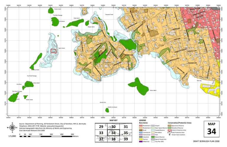
545300 10 7 3 3 17 1 4 16 3 AD Bird Island 1 18 RO 3 E D E P O W D IV R D 1 H IL L 132500 A D R O C K S T IN G R O E V O H A S A D R O S H A R E S IN T O P 6 10 E LE 6 IV R D 8 E 1 19 E R A H 1 O DW WIN 12 4 43 13 8 6 2 5 OD 30 32 4 34 40 36 9 5 45 38 IVE DR 9 3 42 42 31 6 44 4 5 ROXDENE LANE 49 46 46 3 7 28 6 10 2 8 8 H A L C Y 3 57 O N 50 L A N E 55 23 1 3 L D S L IP D A 7 61 54 58 60 62 5 66 2 50 61 72 74 O 26 51 53 L A N E O R 20 Two Rock Passage LANE TURNSTILE 48 S 18 15 9 7 10 3 S T IN Mowbray Island 19 8 11 D ROA NGS HASTI H T R O 9 O W L U L P 7 E D SI 11 11 5 1 T EN SC 3 6 2 Point Shares 17 MIAMBA LANE 3 4 E N A L 16 E 8 8 13 11 9 RE D C E NU IV R D 6 4 OO DW WIN VE T A ON EM 4 K C 1 7 3 41 15 21 17 6 1 7 24 2 9 38 8 12 S LL WA O R 4 3 2 E 6 2 4 37 39 16 14 36 4 12 6 E TH 4 Cemetery 8 2 1 1 V 8 35 E LAN 3 10 11 18 12 EN O L 33 S CAP 9 11 O 5 E N 15 14 D A 3 M L A P O R 5 11 28 32 11 16 27 25 31 30 34 S 10 17 23 E LAN DEN HID 10 E R A H 13 Drains 5 8 S 1 15 Agar's Island T IN 7 IV R D 1 5 6 3 28 132300 3 7 9 22 29 7 5 3 5 12 E 5 7 3 O RIVE M D PAL AG 5 15 16 2 P E LON 11 3 8 10 25 27 8 LL HI 2 14 1 4 1 4 10 4 2 2 6 E OS CL 12 NZ SA 68 12 12 7 40 38 8 2 18 5 4 'S AR 10 ON GT IN 36 T EN SC EE TW BE 132700 4 6 7 P UP 3 10 6 23 26 9 6 2 4 5 8 E CR 546000 34 3 6 1 2 1 6 E N LA 6 19 21 4 CLOSE 4 8 10 E AN Y L OR CT RE Y A B 1 O 3 32 S RO Y P S S 2 VILLE ROCK D OL E K 4 T IN E R A H D A 5 3 545900 1 12 8 O R 6 22 12 13 E 3 5 10 14 NE LA 132800 4 20 16 10 R BE TIM 8 Stipple Island O 18 5 2 18 6 18 2 6 4 17 1 545800 8 19 2 1 545700 1 16 12 1 3 132600 545600 6 1 5 S 7 Goat Island 8 6 E AR SH Fairyland Creek The Mills Passage 132400 5 D OA Y R BA TS PIT L IL M 10 1 545500 4 9 Goose Island 132900 545400 14 133000 545200 11 132900 545100 132800 545000 132700 544900 132600 544800 132500 544700 7 4 Lefroy Island 132400 544600 54 Pitt's Bay Park 6 One Rock 132300 544500 THE WA LLS 544400 BET WE EN 544300 LA NE 544200 HID DE N 544100 133000 544000 132200 132200 Saltus Island One Rock Passage Verrill 132100 132100 Beebe Island World's End 132000 World's End Island 544000 544100 544200 544300 544400 544500 544600 544700 544800 544900 545000 545100 MAP KEY Website: www.planning.gov.bm 30 31 Grid: Bermuda National Grid 2000 0 1:5,000 50 100 200 300 400 500 545400 545500 Base Zones 29 Selected topographic data from the Ministry of Works and Engineering 545300 33 34 35 Meters 37 38 545600 545700 545800 545900 546000 LEGEND Source: Department of Planning, 30 Parliament Street, City of Hamilton, HM 12, Bermuda. Telephone: (441) 297-7778 545200 39 Conservation/Protection Areas Residential 1 Airport Agricultural Reserve Residential 2 Open Space Reserve Woodland Reserve Rural Coastal Reserve Historic Protection Area Commercial Recreation Cave Protection Area Institutional Park Known Cave Locations Industrial Nature Reserve Tourism Special Study Area Mixed Use City Plan 2001 MAP 34 DRAFT BERMUDA PLAN 2008


