Omega Block Weather Pattern Develops This Weekend; Will Impact
advertisement

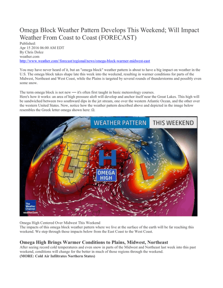
Omega Block Weather Pattern Develops This Weekend; Will Impact Weather From Coast to Coast (FORECAST) Published: Apr 15 2016 06:00 AM EDT By Chris Dolce weather.com http://www.weather.com//forecast/regional/news/omega-block-warmer-midwest-east You may have never heard of it, but an "omega block" weather pattern is about to have a big impact on weather in the U.S. The omega block takes shape late this week into the weekend, resulting in warmer conditions for parts of the Midwest, Northeast and West Coast, while the Plains is targeted by several rounds of thunderstorms and possibly even some snow. The term omega block is not new — it's often first taught in basic meteorology courses. Here's how it works: an area of high pressure aloft will develop and anchor itself near the Great Lakes. This high will be sandwiched between two southward dips in the jet stream, one over the western Atlantic Ocean, and the other over the western United States. Now, notice how the weather pattern described above and depicted in the image below resembles the Greek letter omega shown here: Ω. Omega High Centered Over Midwest This Weekend The impacts of this omega block weather pattern where we live at the surface of the earth will be far reaching this weekend. We step through those impacts below from the East Coast to the West Coast. Omega High Brings Warmer Conditions to Plains, Midwest, Northeast After seeing record cold temperatures and even snow in parts of the Midwest and Northeast last week into this past weekend, conditions will change for the better in much of those regions through the weekend. (MORE: Cold Air Infiltrates Northern States) Above-average temperatures will dominate many cities in the days ahead thanks to the area of high pressure associated with the omega block. An exception to this may be the Northeast coast where onshore winds from surface high pressure may hold off the warmth until late weekend or early next week. Forecast Highs This Weekend Widespread 60s and 70s are in the forecast through this weekend in parts of the Plains, Upper Midwest and Great Lakes. Minneapolis-St. Paul is expected to see multiple days in the upper 60s and low 70s through Sunday, which is 10 to 15 degrees above mid-April averages. The Twin Cities only reached 70 degrees twice this year so far through April 12 but has seen highs already climb into the low to mid 70s on April 13 and 14. (FORECAST: Bismarck | Omaha | Green Bay) In the Northeast, highs will rebound into this 50s on Friday with 60s possible as far north as portions of Pennsylvania and New York. This weekend it will turn even warmer with highs in the 60s across most of New England, while the mid-Atlantic sees 70s. For many areas temperatures may be 10 to 20 degrees above average from Pennsylvania to Maine by Sunday. (FORECAST: Cleveland | Syracuse | Philadelphia) The area of high pressure will also keep much of the East dry through this weekend. Heavy Rain, Severe Weather, Snow in the Central States In the Plains, heavy rain and severe thunderstorms will be the result of this weather pattern starting Friday. The omega high over the Great Lakes will block the forward progression of an area of low pressure that forecast to form in the upper atmosphere over the western states. That low will interact with moisture returning north from the Gulf of Mexico, leading to the development of widespread rain and thunderstorms in the Plains. Rainfall Forecast Repetitive rounds of rain could eventually lead to flooding in some locations, while snow falls on the central and southern Rockies. Not only that, it may be cold enough for snow to pile up in the Rockies and parts of the adjacent High Plains. For full details on the severe weather, flooding and snow this Friday into the weekend, click on the links below. (MORE: Severe Storms, Flooding Take Aim on Plains | Winter Storm Vexo) West Coast Heats Up To the west of the area of low pressure that will bring heavy rain to the Plains will be a northward bulge in the jet stream along a sliver of the West Coast. This will allow warmer than average temperatures to take over the Northwest and California Saturday to Wednesday. In some cases, highs will be 10 to 25 degrees above average. Highs in the 70s will return to Portland, Oregon, this weekend, with Sunday possibly topping out near 80 degrees. Seattle may make a run at 80 degrees by Monday. Portions of California's Sacramento Valley along with southern Oregon will see 80s. A few locations could top out near 90 degrees this weekend. Directions: Using the above article, your chapter 20 vocabulary and concepts, and other reliable Internet sources, draft a claim (5-6 sentences minimum) about what type of fronts will develop across the middle and eastern parts of the United States this weekend. Your claim must include evidence and scientific reasoning as well. Please submit via paper. Student Rubric for Teacher Evaluation: 10-9 Claim, evidence reasoning present Clearly connects vocab & concepts Uses higher level thinking skills: e.g. evaluates, compares/contrasts, develops, designs 8-7 6 Missing one of C, E, or R Rudimentarily connects vocab & concepts Uses lower level thinking skills: Missing more than one of C, E, or R Rudimentarily connects vocab & concepts Uses lower level thinking skills: e.g. define, lists e.g. define, lists


