D C ,
advertisement
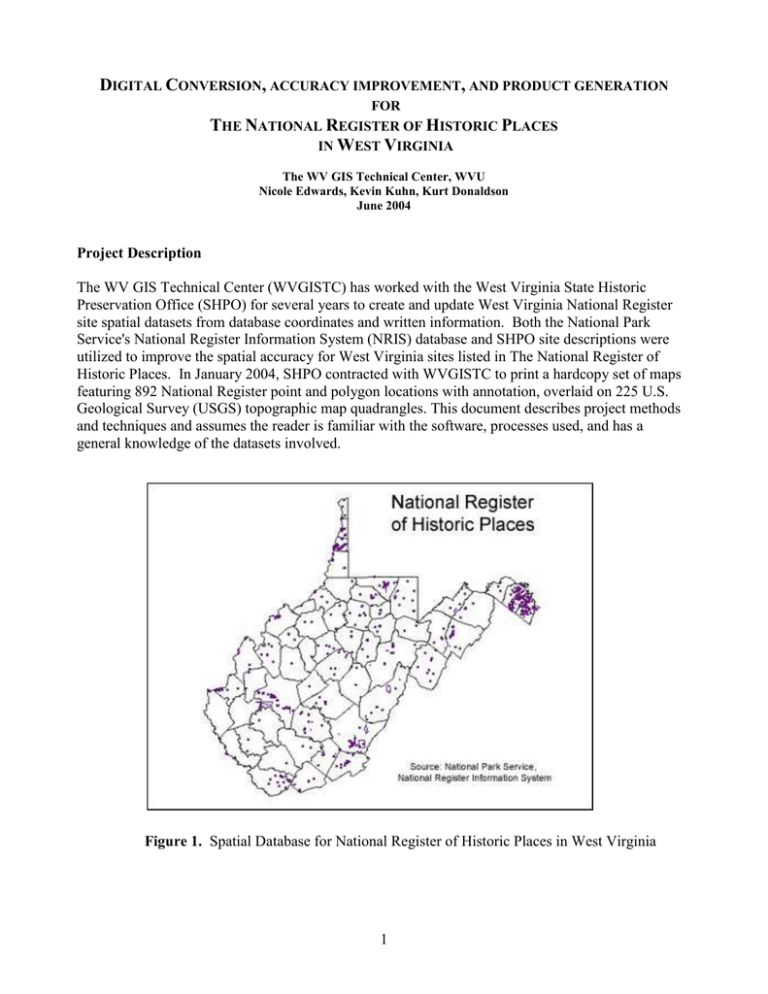
DIGITAL CONVERSION, ACCURACY IMPROVEMENT, AND PRODUCT GENERATION FOR THE NATIONAL REGISTER OF HISTORIC PLACES IN WEST VIRGINIA The WV GIS Technical Center, WVU Nicole Edwards, Kevin Kuhn, Kurt Donaldson June 2004 Project Description The WV GIS Technical Center (WVGISTC) has worked with the West Virginia State Historic Preservation Office (SHPO) for several years to create and update West Virginia National Register site spatial datasets from database coordinates and written information. Both the National Park Service's National Register Information System (NRIS) database and SHPO site descriptions were utilized to improve the spatial accuracy for West Virginia sites listed in The National Register of Historic Places. In January 2004, SHPO contracted with WVGISTC to print a hardcopy set of maps featuring 892 National Register point and polygon locations with annotation, overlaid on 225 U.S. Geological Survey (USGS) topographic map quadrangles. This document describes project methods and techniques and assumes the reader is familiar with the software, processes used, and has a general knowledge of the datasets involved. Figure 1. Spatial Database for National Register of Historic Places in West Virginia 1 Digital Conversion, Accuracy Improvement, and Product Generation for The National Register of Historic Places in West Virginia June 2004 A. DATABASE WORK The National Park Service maintains and updates an on-line National Register database. One of the resources on their website includes a spatial database that contains point and polygon coordinates for national register site locations. The WVGISTC uses the information in the spatial database to update the West Virginia National Register GIS layers. To do this: Retrieve the National Register Access Database 1. Go to http://www.nr.nps.gov/nrdown1.htm, and choose “Geographic files in Microsoft Access database.” This opens a National Park Service FTP connection. Download the spatial.mdb Microsoft Access file. 2. Open the spatial.mdb database by double clicking on it. Currently, the file is an Access 98 database. If you are running Access 2000, you will be prompted to open or convert it. Convert the file to 2000, giving it a new file name. In the past, spatial2000.mdb was used. 3. The spatial.mdb database contains 5 tables. The contents of these tables are described in the readme at the FTP location where the database was retrieved: http://www.nr.nps.gov/NRISGEO/readme.txt. The main, polygon, and point tables are used to retrieve updated geospatial feature information. Create New Tables in the Access Database 1. First, do a query on the main table to select all the features with West Virginia as the state. The results of this query create a list of all the features (and their associated refnum—unique identifier) that SHOULD be in the National Register spatial datasets. Perform a make table query, creating a new table containing only the WV data from the main table, keep all fields. For purposes of this description we will call it the WV_NR_ShouldHave table, although it could have any name. 2. Make a table in the Access database, which contains all the refnums that ARE in the current National Register spatial datasets. This can be done by working with the .dbf portion of the existing point and polygon shapefiles (on the WVGISTC FTP site, ftp://ftp.wvgis.wvu.edu/pub/ Clearinghouse/cultural/NR/). Copy the values in the refnum field of each of those files, and paste them in one column of a new excel document. Then sort and remove duplicates. 3. Import the new excel file into the Access database, as a new table. The table will have just the refnums in it. For purposes of this description, we will call it the WV_NR_DoHave table, although it could have any name. Compare Tables in Access to Determine New Records 1. Now there are 2 tables to compare: (1) the table that is a subset from the downloaded National Register main table, which contains WV refnums we SHOULD have, and (2) a table that was derived from our current shapefiles; containing the WV refnums that we DO have. Perform a query joining the two tables on the refnum field. Set the query relationship to show ALL the 2 Digital Conversion, Accuracy Improvement, and Product Generation for The National Register of Historic Places in West Virginia June 2004 refnums in the WV_NR_ShouldHave table and the matching records in the WV_NR_DoHave table. If new records have been added to the national dataset, some of the refnums in the WV_NR_ShouldHave table will not have matches in the WV_NR_DoHave table. Those will be the “new” records that need to be added to the dataset. Point and Polygon Identification and Export to dBase 1. Once it is known which refnums need to be added to the dataset, figure out which ones are points and which ones are polygons. This can be done by a manual comparison or various queries, depending on the users comfort level with Access. The new refnums from the main table will show up in the point or polygon table, not both. Refnums in the point table will have one set of coordinates, whereas refnums in the polygon table will usually have 3 or more sets of coordinates, corresponding to vertices in the polygon. 2. The datum on the UTM coordinates is NAD27, as described in the following: http://www.nr.nps.gov/NRISGEO/datum.txt (found on the FTP site where the database was downloaded). 3. The records associated with new features can be exported out of Access to excel files (one for points and one for polygons). The goal is .dbf files, for import into ArcMap; however, saving from Access directly to dbase is problematic, and therefore the access data should be saved to excel, and then from excel to dbase. From excel, save the data into .dbf files – remembering to check and see that the fields with the coordinates in them are number fields and not string. B. DATA DEVELOPMENT IN ARCMAP Point Generation and Polygon Creation 1. Add the .dbf tables to ArcMap and use the “add XY” procedure to add the new point coordinates. Initially, point layers will be created from both the point and polygon .dbf files. The polygons right now are represented by their vertices, which need to be connected to make polygons. When the first National Register polygon layer was created, ALL the polygons were built from points using the the Edit Tools extension, available at http://www.ianko.com/. It is possible too, that there are some scripts on the ESRI website for doing mass conversion of points to polygons. However, it has been found that the polygons created from these vertices are often very poorly shaped. The “Shapefile Update Procedures” Section below describes the polygon correction methods. 2. Once the new features are in shapefile format with the correct fields and field types, they can be appended to the existing shapefiles using the merge geoprocessing wizard to produce final, updated polygon and point shapefiles. Shapefile Update Procedures 1. When creating the first national register polygon layer, polygons were automatically generated from points. The national database record contains an acreage value field. The stated acreage was compared with the calculated acreage of each polygon. The calculated 3 Digital Conversion, Accuracy Improvement, and Product Generation for The National Register of Historic Places in West Virginia June 2004 area was determined by using a polygon area calculation available in ArcMap (See “Field Calculations” in ArcMap help). Comparing the difference between the two acreage values, we generated a list of polygons to be updated, with a higher priority given to the polygons with the greater difference. Eventually, all polygons were updated in a somewhat manual fashion. 2. Polygon site boundaries were updated from printed site descriptions and boundary location maps (when available) provided by SHPO. This included interpretation of the verbal boundary descriptions and paper maps provided. Note: some site descriptions included the mapped outline on a USGS Topographic map which was helpful for locating the boundary, though this did not offer a high level of detail. Other sites included a detailed map of the site (such as a local street map), but not an outline on a USGS Topographic map, which made it difficult to initially locate the site. 3. Point locations were verified for location by the address in the attribute table and whether or not they fell within their stated county (and city when available). The accuracy of these checks is questionable, due to the lack of reference information. For example, a verbal building location description that read, “…next to the bank, across from the firehouse…”, was not always useful, because it cannot be interpreted on our reference maps or cannot be verified without local knowledge. Points found to be outside their stated county were moved as close to their actual location as was possible with the given information. C. HARDCOPY MAP PREPARATION General Procedures This section describes the general procedures for the printing and softcopy generation (PDFs) of 892 historic sites on 225 USGS 1:24,000-scale topographic map quadrangles. Completed, point and polygon shapefiles were imported into a personal geodatabase. The geodatabase contained point and polygon feature classes for non-restricted and restricted sites. It also contained a separate annotation group for each layer. The annotation layers allowed for quicker changes to feature annotation and greater drawing speed, plus improved the computer performance while working on a statewide dataset. See the Symbology Section below for more specific information on the annotation. Feature datasets were loaded into ArcMap along with the newest available USGS Topographic maps (the digital version is referred to as a DRG; digital raster graphic). Digital ortho-photo quarter quads (DOQQs; aerial photography) were also used as a reference when needed. Each point and polygon National Register feature on a quad was checked and annotated individually. This was necessary because of the map print scale; the density of points and polygons in some areas caused overlapping labels that needed to be moved. Though time-consuming, this method proved to be useful in keeping track of features that had been corrected and also served as a quality check for the statewide feature data sets. After all revisions to the features and annotation in a quad were made, the ArcMap project MXD file was saved, and a PDF was generated from ArcMap. Saving one MXD file per quad enables quick future access to all layers and formatting associated with each quad. 4 Digital Conversion, Accuracy Improvement, and Product Generation for The National Register of Historic Places in West Virginia June 2004 Symbology In ArcMap 1. Custom symbols were created for the point features. The symbols were an open circle marker and a single 2pt line was used for the polygon features. See Appendix B for map examples. 2. The font used for the annotation was Arial, 10pt, Bold. See Appendix B for map examples. 3. The final colors chosen by SHPO were: point sites -blue text with a white halo and blue leader line with a black shadow; polygon sites - red text with a white halo and a red leader line with a black shadow. The symbologies of the restricted and non-restricted sites were identical, except that the restricted site annotation color was distinguished by yellow text with a black halo. Note: The colors that were chosen provided good contrast to the majority of background colors found on the topographic map. The white halo around the text defined the annotation text from underlying text or features of the same or similar color. 4. Leader lines were used to eliminate the annotation clutter in dense areas. They enabled the text labels to be placed away from the collection of points, without covering up information about the surrounding area. Since the leader lines are the same color as the features, a shadow was used to help distinguish them from roads and other features on the map. Printing 1. Maps were exported from ArcGIS using the “export map…” utility to PDF at 200dpi. This resolution is a good compromise between quality and the PDF file size. The DRGs are low resolution; therefore increasing the resolution of the exported PDF would not improve printing clarity. File sizes of the PDFs ranged from 1.3mb – 4.5mb. Over 200 files were smaller than 3mb. 225 PDF files were created, with a total file size of 514mb. 2. PDF files exported from ArcMap were printed from Adobe Acrobat. This was done to make sure that the PDF was encoded correctly from ArcGIS. 3. Maps were printed at scale of 1:24,000 (Actual size of the original USGS Topo Map) on 32lb heavy weight coated, “Arch D” size paper. 4. A 24k quad index grid was used for tracking the PDF files and printed maps. Any quad containing a feature was highlighted and marked by color. A printed version of this map was used to track the project’s progress. 5 Digital Conversion, Accuracy Improvement, and Product Generation for The National Register of Historic Places in West Virginia June 2004 Appendix A. Feature Details 1. 2. 3. 4. 5. National Register Unrestricted Point Features = 661 National Register Restricted Point Features = 23 National Register Unrestricted Polygon Features = 195 National Register Restricted Polygon Features = 13 892 features total on 225 quads Appendix B. Example Map Images Figure B-1. Middlebourne Quad Figure B-2. Martinsburg Quad 6
