SOLAPUR UNIVERSITY SCHOOL OF EARTH SCIENCES M.SC. APPLIED GEOLOGY 2015-2016 ONWARDS
advertisement

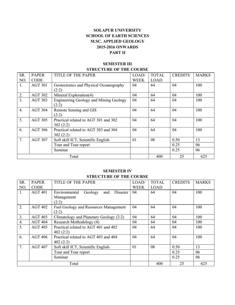
SOLAPUR UNIVERSITY SCHOOL OF EARTH SCIENCES M.SC. APPLIED GEOLOGY 2015-2016 ONWARDS PART II SR. NO. 1. PAPER CODE AGT 301 2. 3. AGT 302 AGT 303 4. AGT 304 5. AGT 305 6. AGT 306 7. AGT 307 SEMESTER III STRUCTURE OF THE COURSE TITLE OF THE PAPER LOAD/ WEEK Geotectonics and Physical Oceanography 04 (2:2) Mineral Exploration(4) 04 Engineering Geology and Mining Geology 04 (2:2) Remote Sensing and GIS 04 (2:2) Practical related to AGT 301 and 302 04 302 (2:2) Practical related to AGT 303 and 304 04 302 (2:2) Soft skill ICT, Scientific English 01 Tour and Tour report Seminar TOTAL LOAD 64 CREDITS MARKS 04 100 64 64 04 04 100 100 64 04 100 64 04 100 64 04 100 08 0.50 0.25 0.25 13 06 06 Total SR. NO. 1. PAPER CODE AGT 401 2. AGT 402 3. 4. 5. AGT 403 AGT 404 AGT 405 6. AGT 406 7. AGT 407 SEMESTER IV STRUCTURE OF THE COURSE TITLE OF THE PAPER LOAD/ WEEK Environmental Geology and Disaster 04 Management (2:2) Fuel Geology and Resources Management 04 (2:2) Climatology and Planetary Geology (2:2) 04 Research Methodology (4) 04 Practical related to AGT 401 and 402 04 402 (2:2) Practical related to AGT 403 and 404 04 402 (2:2) Soft skill ICT, Scientific English 01 Tour and Tour report Seminar Total 400 25 625 TOTAL LOAD 64 CREDITS MARKS 04 100 64 04 100 64 64 64 04 04 04 100 100 100 64 04 100 08 0.50 0.25 0.25 13 06 06 400 25 625 AGT 301: GEOTECTONICS AND PHYSICAL OCEANOGRAPHY: 70 marks Unit 1: Plate tectonics; Basic concepts and definition, types of plate margins their characters and associated processes like magnetism, seismicity, volcanism mountain belts, Benioff zones. Tectonic evolution of continents, cratons and ocean basins.Tectonic of Indian sub continent. Orogenesis: Precambrian and Phanerozoic orogenesis, source and nature of tectonic forces, comparision of hypothesis of orogenesis – contraction, expansion, convection, Plume hypothesis and micro plate tectonic, Continental drift and sea floor spreading. Tectonic model of evolution of the Himalayas. Unit 2: Morphologic and tectonic domains of the ocean floor.Structure, composition and mechanism of the formation of oceanic crust.Seawater-basalt interactions, hydrothermal vents- chemical and biological significance of hydrothermal vents systems.Ocean margins and their significance.Opening and closing of ocean gateways and their effect on circulation and climate during the Cenozoic. Sea level processes and Sea level changes. Unit 3: Estuaries: classification and nomenclature; tides in estuaries; estuarine circulation and mixing; depth – averaged and breadth – averaged models; sedimentation in estuaries; salinity intrusion in estuaries; effect of stratification; coastal pollution; mixing and dispersal of pollutants in estuaries and near-shore areas; coastal zone management. Oceanic sediments: Factors controlling the deposition and distribution of oceanic sediments; geochronology of oceanic sediments, diagenetic changes in oxic and anoxic environments. Unit 4: The global wind system; action of wind on ocean surface; Ekman’s theory; Sverdrup, Stommel and Munk’s theories; upwelling and sinking with special reference to the Indian ocean. Inertial currents; divergences and convergences; geostrophic motion; barotropic and baroclinic conditions; oceanic eddies, relationship between density, pressure and dynamic topography; relative and slope currents. Wind driven coastal currents; typical scales of motion in the ocean. Reference Books :The evolving continent by Windley. Plate Tectonic and crustal Evolution by Condie. Marine Geology by J.Kennet Aspects of Tectonics by Waldiya. INTERNAL EVALUATION (Seminar + Term paper + Test) (30 Marks) AGT 302 MINERAL EXPLORATION (70 marks) Unit 1: Introduction to prospecting and exploration: scale of prospecting; classification of prospecting methods, objectives of exploration, principles of exploration, methods and stages. Optimization of exploration: planning, choice of exploration methods, integrated exploration sequence, organization and operation during exploration. Evaluation of mineral deposit at various stages of exploration, workable standards. Prospecting criteria and guides, geological criteria, climate, stratigraphy, facies and lithological aspects, structure and geological aspects, geochemical and geophysical anomalies, geological conditions favorable for prospecting. Unit 2: Exploration equipments and system, exploration openings, reconnaissance bore holes drilling system, exploration by underground and bore hole workings. Factors affecting choice of system. Methods and types of sampling, choice of sampling, sample spacing, grading mineral deposit, sample error and check. Introduction to geophysical prospecting, classification and types of prospecting methods, concept and principles of gravity and magnetic surveys, anomalies, their correction, instrumentation and field data acquisition, interpretation and application to geological problems Concept of seismic reflection and refraction methods, instrumentation and field data acquisition, preparation of travel times curves, identification of subsurface structure Unit 3: Types of electrical surveys, electrode configuration, field data, resistivity methods interpretations of subsurface lithology and structures by qualitative and quantative analysis. Radiometric prospecting, principles and concept, GM and scintillation counters, field data acquisition and interpretation. Subsurface Geophysical exploration: Types of Well Logging, Instruments, subsurface structural and stratigraphic correlation. Unit 4: Geochemistry in mineral exploration, classification of geochemical surveys, association of elements, mobility and path finder elements. Geochemical dispersion and landscape: patterns of deep seated origin, formation of productive plutons, geochemical provinces, host rock petrochemistry, ores related to productive plutons. Biogeochemical and geobotanical surveys: choice of sampling medium and their anomalies, mapping technique, merits and demerits, biogeochemical and geobotanical indicators. Data handling and statistical interpretation of data, organization and data bank, univariate and multivariate analysis, calculation of background, threshold and cut off values. . . Reference Books: 1. 2. 3. 4. 5. 6. 7. 8. 9. Geological prospecting -- Kreiter Mineral Exploration by A.W. Rose, H.E. Hawkes & J.S. Webb Rock geochemistry in mineral exploration by G.J.S. Govette Elsevier Analytical methods in geochemistry prospectingby Fleteher W.K.Elsevier Geochemical exploration methods for mineral deposits.by Beus A.A. & Grigorian S.V. Introduction to geophysical prospecting by Dobrin M.B. Outlines of geophysical prospecting for geologists.by Ramchander Rao. M.B. -Fundamentals of Geophysics by William Lowric Applied Geophysics by Telford W.M., Geldart L.P. & Sheriff R.E. INTERNAL EVALUATION (Seminar + Term paper + Test) (30 Marks) AGT 303: ENGINEERING GEOLOGY and MINING GEOLOGY (70 marks) Unit 1: Engineering properties of rocks., rock discontinuity, physical characters of building stones. Modulus of elasticity for rocks, modulus of deformation.Geological investigation for civil engineering.Project for site selection of dams and reservoir.Dams foundation rock problem. Geotechnical evaluation of tunnel alignment, bridgesand transportation routes. Unit 2: Mass movement – land slides and causes of hill slope instability.Earthquakes and seismicity, seismic zones of India. Types of engineering structures involved in watershed management.Problems of groundwater in engineering projects.Geotechnical case studies of major projects in India. Unit 3: Application of rock mechanics in mining, planning, exploration and exploratory mining of surface and underground mineral deposit involving diamond drilling, shaft sinking, drifting cross cutting, winzing, stopping, room and pillaring, top-slicing, sub level caving and block caving, cycles of surface and under ground mining operations. Unit 4: Exploration for placer deposit. Open pit mining. Ocean bottom mining , types of drilling methods viz. diamond drilling and chern drilling. mining hazards-mine diseases, mine inundation, fire and rock burst, mine gasses, open cast and underground mining methods. Reference Books :Engineering Geology by Davis. Engineering Geology by Parbeen singh. Principle of Engineering Geology by Krynnen and Judd Geology and Engineers by Laggets Mining geology by Mckinstry Elements of mining by Clark G.B Courses in mining geology by Arogyaswami R.P.N. Introduction to geophysical prospecting by Dobrin INTERNAL EVALUATION (Seminar + Term paper + Test) (30 Marks) AGT 304: REMOTE SENSING and GIS: 70 marks Unit 1: Concept of Remote Sensing : Electromagnetic energy, Interaction of EMR with atmosphere and earth material, atmospheric windows, EMR spectrum. Platforms, sensor types, MSS. Aerial Remote Sensing : Flight planning, types of aerial photographs. Photogrammetry – stereoscopic vision, scale, relief displacement, parallax, vertical exaggeration. Satellite Remote Sensing : LANDSAT & IRS characteristics, products and FCC. Unit 2: Interpretation techniques, visual and digital in brief.Recognition of photo elements and terrain elements like size, shape tone, texture, pattern, shadow, sight and association. Terrain analysis: Relief, landforms, drainage pattern. Use of remote sensing in lithology, structure and geomorphology.Application of remote sensing in groundwater and mineral exploration. Unit 3: Basic concept of GIS, components, history and applications.Hardware and software requirement for GIS.Map features, scale, resolution, accuracy and database extent. Map projection and parameters: Geographical co-ordinate system, types of projection and parameters, projection transformation and managing in GIS. Unit 4: Geospatial data models: Spatial and non-spatial data, VECTOR AND RASTER models. GIS ANALYSIS : Digitization, editing and structuring of map data, overlay analysis. Digital elevation and terrain models (DEM/DTM),buffer analysis and query analysis. Use of GIS in lithological, structural, groundwater and mineral exploration.Introduction to Global Positioning System,and its applications and limitations. Reference Books Principles and applications of photogeology by S.N. Pande Photogeology and regional mapping by J.A.E. Allum. Remote sensing and image interpretation by Lilley sand Photogeology by Miller and Miller. Thermal and microwave remote sensing by Sabins. Photogeology byPanda Textbook of Remote sensing and GIS by M. Anjireddy INTERNAL EVALUATION (Seminar + Term paper + Test) (30 Marks) AGT 401 ENVIRONMENTAL GEOLOGY AND DISASTER MANAGEMENT (70 marks) Unit 1: Concept of ecosystem – biotic communities, food chain and Ecologic Pyramids.Impact of anthropogenic activities on air, water and soil resources. Their types, sources and causes of pollutants, Controlling measures. Unit 2: Waste: Source and classification of waste products. Waste disposal and recycling methods. Control and management of waste materials.Impact assessment of anthropogenic activities such as urbanization, open cast mining and quarrying, disposal of mine and radioactive wastes, fly ash,use of fertilizers. Environmental protection – legislative measures in India. Unit 3: Study of Natural Hazards like meteorite impact hazard, landslides, floods and drought, earthquakes, mining, volcanic eruptions: their classification, causes, assessment, prediction and controlling measures. Use of GIS and remote sensing in reduction of natural disasters.Preparedness for relief and recovery operations. Unit 4: Case histories of natural disasters of India viz. Koyana earthquake, Killari earthquake, Uttar Kasi earthquake, Uttarakhand floods, East coast cyclones, Tsunami, drought prone regions of India with special reference to Maharashtra, Reference: Environmental chemistry; A.K. De Environmental Geology; Killer Environmetal Geology; Valdiya Mineral economics : Sinha and Roy. Mineral economics : Chatterjee. Indian Bureau of Mines, Govt. of India. Handbook of energy technology by V. Daniel Hunt. INTERNAL EVALUATION (Seminar + Term paper + Test) (30 Marks) AGT 402 FUEL GEOLOGY AND RESOURCES MANAGEMENT (70 marks) Unit 1 : Role of fuels in National development, Types of fuels, Conventional and Non-Conventional energy resources.eg. Fossil fuels, Coal, Petroleum, Natural gas, Ocean Thermal energy, Wind energy, Biomass energy and Geothermal energy, Tidal energy, Solar energy. Status of Conventional and Non- Conventional energy resource in India. Unit 2 : Physical properties of petroleum, composition of petroleum and natural gas; genesis of hydrocarbons, conversion of organic matter to petroleum, migration and accumulation of oil; study of reservoir rocks, trap rocks and cap rocks; different types of traps including structural traps, stratigraphic traps and combination traps, salt dome; methods of petroleum exploration; Enhanced recovery operations for petroleum and natural gas.Oil producing basins of India and their stratigraphy and structure. Unit 3: Origin and composition of coal, Coal petrographic and petrological study, classification of coal deposits, coalification, chemical constituents of coal, distribution and stratigraphyof Tertiary and Gondwana coal in India. Unit 4 : Introduction to various radioactive minerals, their half lives and breeding characteristics. Use of atomic energy as alternative energy resource.Nature and types of Uranium deposits and their occurrence and genesis. Nuclear fusion and Nuclear breeder. Nuclear waste and its management.Atomic mineral .Distribution in India.Brief introduction to radioactive surveys. Reference Books Petroleum Geology by F..K. North Petroleum formation and occurrence by Tissot and Welte Petroleum asia journal, A.A.P.G. Journal Handbook of Energy Technology by V.D. Hunt Introduction to Petroleum geology by Hobsson and Tirtsoo. Nuclear Geology by Ashwathnarayan Development in Petroleum Geology by Hobson. Coal Deposits by Tatsch Petroleum Development in Geology by Dicky Geothrmal Systems by Reach and Mufflur. Petroleum Geology by Levorson INTERNAL EVALUATION (Seminar + Term paper + Test) (30 Marks) AGT 403 CLIMATOLOGY AND PLANETARY SCIENCE (70 marks) Unit 1: Nature and scope of climatology, development of modern climatology and tropical climatology, Earth’s atmosphere: evolution, structure and chemical composition, Solar radiation and terrestrial radiation: electromagnetic spectrum, latitude and seasonal variations, effect of atmosphere, greenhouse effect and heat budget, Temperature measurements and controls, lapse rate and inversion of temperature. Unit 2: Atmospheric pressure and winds: pressure measurement and distribution, wind observation and measurement, factor affecting wind, geostrophic wind and gradient wind, local winds, models of general circulation of the atmosphere, Jet stream, Atmospheric moisture: forms of condensation and precipitation, hydrological cycle, Stable and unstable atmosphere: environmental lapse rate, dry and wet adiabatic lapse rate and atmospheric stability, Air masses: classification and modification, Fronts: characteristics and types, Classification of climates : Thornthwaite’s and Koppen’s classification. Unit 3: Solar system : major concepts, planets, satellites, asteroids, meoteorites and comets; formation and internal differentiation of the planets; general features of terrestrial and Jovian planets. Planetary atmosphere; exogenic and endogenic processes association with origin and internal evolution of planets – Planetary volcanism, craters, impact cratering processes, elemental composition, mineralogy and petrology; thermal, seismic and magnetic properties and chronological techniques. Unit 4: Planetary surfaces, atmospheres, interiors, magnetic fields, and ring systems and their associated origins and processes will be explored. Also, the Sun and its effects on the planets will be addressed. The moon and its terrestrial analog IO, Phobos and Deimos, minor bodies such as asteroids, comets, meteorites.Past, present and future planetary exploration mission. Reference books: Foure G., and Mensing T.M., Introduction to Planetary Science Taylor and Francis, Introduction to Planetary Geology INTERNAL EVALUATION (Seminar + Term paper + Test) (30 Marks) AGT 404 :RESEARCH METHOLOGY (70 marks) Unit 1: Formulation of Research Problem:Criteria of good research, types of research, significance, literature review,purpose, process of literature review, analysis of an article, search engine,formulation of research problems. Unit 2: Definations of problem, objectives of research,planning of experiments, data collection and recordkeeping, results and discussions, presentation of research outcome as a researchpaper or filing patent. Unit 3 : Indices, publications, types, Impact factor, calculation of Impact Factor, uses, Calculation of immediacy Index, SCOPUS index, h – index, advantages, criticism ISSN, ISBN. Unit 4: Various search engines available on internet, normal vs advanced search, key –words, formulation of search statement, Listing various journals in relevanttopic, Science abstracts, e – database. Application of Computers in research, internet browsing, tool bar options,provisions of MS – word, MS – Excel, MS – PowerPoint, Origin. Reference Books: 1. Research Methods - Ram Ahuja, Rawat Publications 2. Philosophy of Science – Mario Bunge, Transaction Publishers 3. Research Methodology - Methods and Techniques, C. R. Kothari New Age 4. Fundamentals of Statistics - Goon, Gupta and Das Gupta (Vol. I & Vol. II) INTERNAL EVALUATION (Seminar + Term paper + Test) (30 Marks) AGP 305 PRACTICAL RELATED TO AGT 301 AND AGT 302 (70 marks) Practical AGT 301 (Geotectonics and Physical oceanography) Study of Tectonic elements of the given tectonic maps. Identification of palaeotectonic regimes and delineating their characterstics. Identification of different tectonic features in the given map/ sketches. Study of tectonic maps of different parts of India. Interpretation of Neotectonic features using aerial photographs. Maps related to Ocean features Practical AGT 302 ( Mineral exploration) Reserve calculation problems Problems on structures and site selection Management of resources Types of reconnaissance and determinative mineralogical aspects. Sample analysis using AAS * Mineral characterization using XRD * *With the help of common facility centre of Instrumentation. INTERNAL EVALUATION (Viva-voce + Journal + Data evaluation ) (30 Marks) AGP 306 PRACTICAL RELATED TO AGT 303 AND AGT 304 Practical AGT 303 ( Engineering Geology and Mining Geology) (70 marks) Practicals of Engineering Geology: Salient points for the construction of contours of bunds, stream bunds, percolation tank, subsurface dam etc. Use of morphometric analysis in planning watershed development. Plotting of chemical data of water samples from watershed area. Structural maps for engineering construction Engineering properties of rocks. Determination of Rock strength and soil strength. Ground subsidence and their improvement techniques. Practicals of Mining Geology: Mine valuation and calculation Mine survey problems. Terminology of mines Calculation of reserve Practical AGT 404( Remote Sensing & GIS) Determination of photo scale and height determination Study of different erosional, depositional landforms and tectonics landforms. Interpretation of lithology and structures from aerial photographs and satellite imageries. Study and analysis of lineaments and drainage from aerial photographs. Nature of sources of geographical data. Georeferencing and digitization Preparation of DEM/DTM Slope, buffer, mosaicing and overlay analysis INTERNAL EVALUATION (30 Marks) (Viva-voce + Journal + Data evaluation ) EACH SEMESTER WILL HAVE 1 CREDIT (25 MARKS) FOR – FIELD TRAINING FOR LONG TOUR/IN PLANT TRAINING/INDUSTRIAL VISIT OR RECONNAISSANCE FIELD WORK DATA ACQUISITION RELATED TO DISSERTATION. AGP 405 PRACTICAL RELATED TO AGT 401 AND AGT 402 (70 marks) Practical AGT 401 ( Environmental Geology & Disaster Management) Identification and mapping of natural hazards and zones and terminology of the associated features: viz, floods, landslides, glaciers, with the help of topographic sheets, aerial photographs and LANDSAT imageries. Determination of pollutants from surface and subsurface water samples. Assessment of the mining hazards with respect to case histories. Classification of coastal zones and mapping. Utilization of coastal environmental maps with the help of toposheets, aerial photographs and LANDSAT imageries. World wide distribution of disasters. Mapping of disaster prone zone with the help of remote sensing. Study of case histories of natural disasters in India. Practical AGT 402 (Fuel Geology and Resources Management ) Coal types rank and grid, proximate analysis of coal Reserve calculation, preparation of polished sections Study of section under the microscope, petrography of coal, physical properties of crude, Incipassination and palaeontological remains of coal Flash point and smoke point of crude, refractive index for crude. Calculation of reservoir, petroliferous basins of India. Identification of radioactive minerals. Isopach maps of petroleum reserve Reserve calculation problems Problems on structures and site selection Management of resources Types of reconnaissance and determinative mineralogical aspects. Microscopic studies of ores, coal, placer minerals. Identification, testing and evaluation of gem minerals and their quality improvement suggestion. INTERNAL EVALUATION (Viva-voce + Journal + Data evaluation ) (30 Marks) AGP 406 PRACTICAL RELATED TO AGT 403 AND AGT 404 (70 marks) Practical AGT 403 ( Climatology and Planetary Geology) Interpretation of daily weather report Wind rose diagram; Line graph; Dispersion diagram Study of Planetary images and construction of geological maps from orbital images of Terrestrial planets. Study of meteorites. Practical AGT 404 (Research Methodology) Students had to do project work on allotted topics INTERNAL EVALUATION (30 Marks) (Viva-voce + Journal + Data evaluation ) EACH SEMESTER WILL HAVE 1 CREDIT (25 MARKS) FOR – FIELD TRAINING FOR LONG TOUR/IN PLANT TRAINING/INDUSTRIAL VISIT OR DATA ACQUISITION RELATED TO DISSERTATION. RECONNAISSANCE FIELD WORK


