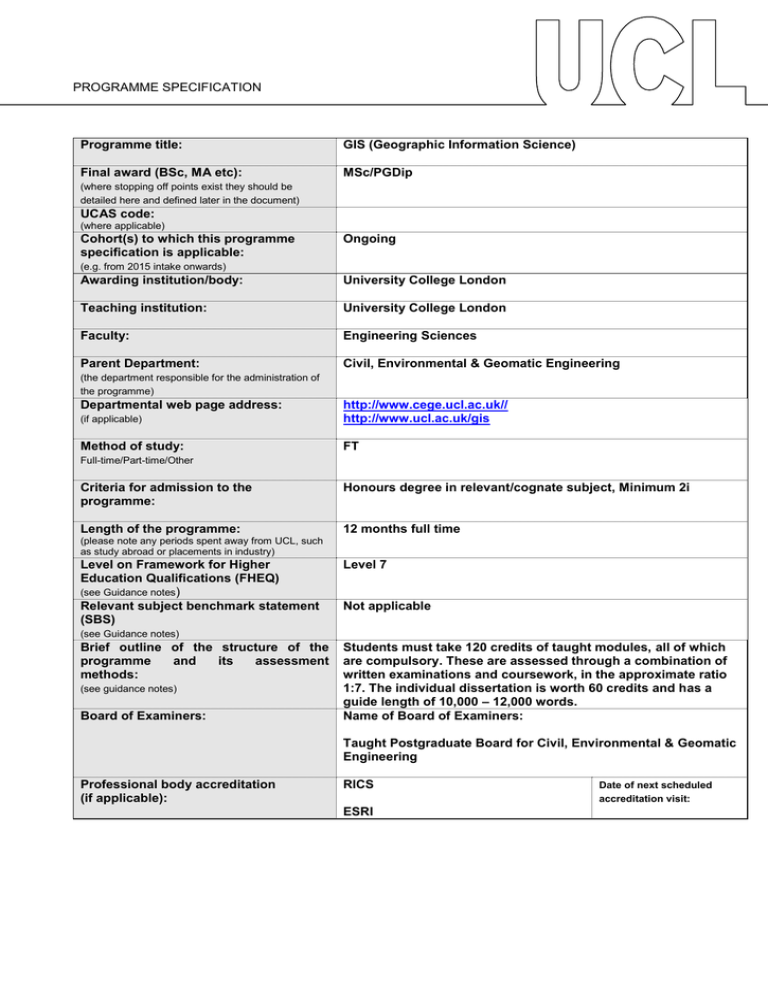
Programme title: GIS (Geographic Information Science) Final award (BSc, MA etc):
advertisement

PROGRAMME SPECIFICATION Programme title: GIS (Geographic Information Science) Final award (BSc, MA etc): MSc/PGDip (where stopping off points exist they should be detailed here and defined later in the document) UCAS code: (where applicable) Cohort(s) to which this programme specification is applicable: Ongoing (e.g. from 2015 intake onwards) Awarding institution/body: University College London Teaching institution: University College London Faculty: Engineering Sciences Parent Department: Civil, Environmental & Geomatic Engineering (the department responsible for the administration of the programme) Departmental web page address: (if applicable) http://www.cege.ucl.ac.uk// http://www.ucl.ac.uk/gis Method of study: FT Full-time/Part-time/Other Criteria for admission to the programme: Honours degree in relevant/cognate subject, Minimum 2i Length of the programme: 12 months full time (please note any periods spent away from UCL, such as study abroad or placements in industry) Level on Framework for Higher Education Qualifications (FHEQ) (see Guidance notes) Relevant subject benchmark statement (SBS) Level 7 Not applicable (see Guidance notes) Brief outline of the structure of the programme and its assessment methods: (see guidance notes) Board of Examiners: Students must take 120 credits of taught modules, all of which are compulsory. These are assessed through a combination of written examinations and coursework, in the approximate ratio 1:7. The individual dissertation is worth 60 credits and has a guide length of 10,000 – 12,000 words. Name of Board of Examiners: Taught Postgraduate Board for Civil, Environmental & Geomatic Engineering Professional body accreditation (if applicable): RICS ESRI Date of next scheduled accreditation visit: EDUCATIONAL AIMS OF THE PROGRAMME: The programme is designed to educate students in the theoretical, scientific and practical aspects of geographic information science. This covers a range of topics from qualitative and quantitative spatial analytical techniques to web and mobile mapping, GI system design, spatial database design and management and advanced spatiotemporal data mining. Graduates are given a solid grounding in the scientific principles underpinning spatial analysis and the computational foundations of GIS, as well as a broader practical understanding of topics such as analysis of the needs of a GIS user, modern programming environments and database management systems and their application within Geographical Information Systems. PROGRAMME OUTCOMES: The programme provides opportunities for students to develop and demonstrate knowledge and understanding, qualities, skills and other attributes in the following areas: A: Knowledge and understanding Knowledge and understanding of: 1. The theoretical and analytical aspects of Geographic Information Science, including the geometrical and coordinate framework in which work is carried out, and the physical environment within which measurements are made, as well as the techniques for data processing, manipulation, and analysis. 2. A range of visualisation techniques for displaying geographic data, including human factors associated in design of these displays and geographic information systems 3. The management, professional, and legal issues that apply within the geomatics industry and the developments that will shape its future. 4. The principles underlying the management and analysis of spatial data and use of basic mathematical, statistical and computational processes for analysis of data 5. Programming techniques for manipulation of existing systems and for design of custom-made applications Teaching/learning methods and strategies: For each generic area, teaching and learning is through lecture courses, practical classes, demonstrations and tutorials. Management and professional issues are in addition supported by a series of 14 external speakers from industry, a GIS-specific careers event which includes mock interviews and CV reviews and visits to industrial and government establishments, such as Ordnance Survey. Students are encouraged to actively participate in the various GIS activities around London. Assessment: Through unseen written examinations, assessed group and individual coursework. Testing of knowledge is also through formal presentations. B: Skills and other attributes Intellectual (thinking) skills: 1. Explain the generic concepts and science of GIS – having a good grasp of theories from Geomatics, Geography, Computer Science, Statistics, Environmental Engineering and related areas. 2. The ability to evaluate and critique existing data analysis and system development and design, and propose alternative avenues where appropriate. 3. The ability to assess the nature and impact of economic, environmental, safety and commercial aspects of a real-world problem through an integrated Geographic Information Science approach 4. The ability to manage, understand and analyse information and data 5. Creativity and independence of judgement. Teaching/learning methods and strategies: “Problem” classes and practical exercises. Seminars and group discussions. Assessment: Oral presentations and written submissions of coursework. Also through students’ analysis and questioning of their colleagues’ work. C: Skills and other attributes Practical skills (able to): 1. Competent in the use of commercial and Free and Open Source GIS software 2. Implement typical GIS routines algorithms (using a high level language such as Java, Python) 3. Manage data acquisition and digital mapping projects – including quality control over the acquisition of spatial data. 4. Describe the structures used for spatial data and apply query languages in relation to database management systems 5. Undertake user requirement analyses, understand user interaction with GI Systems 6. Develop web and mobile Apps that make use of location as an underpinning element 7. Perform in-depth analysis on large spatial and spatio-temporal datasets. Teaching/learning methods and strategies: Practical skills are taught alongside specialist knowledge, using the same range of teaching methods, such as practical exercises, demonstrations, and individual and group coursework. Coursework reports and dissertation projects provide the opportunity of greater student involvement in the development of proposals, design of methodological framework, data acquisition and specialist analysis. Assessment: Submitted coursework Final dissertation D: Skills and other attributes Transferable skills (able to): 1. Use a range of techniques for numerical analysis. 2. Use advanced IT skills, including the ability to program in at least one language, e.g. Java and Python (in addition to enhanced basic IT skills: use of spreadsheets, word processing, presentations, etc). 3. The ability to retrieve and analyse information from a range of sources. 4. The ability to communicate effectively with co-workers and supervisors, and to participate effectively in all levels of project management. 5. The ability to communicate technical and non-technical information clearly and effectively, both orally and in writing, to both specialist and nonspecialist audiences. 6. The ability to present and display a range of information, both quantitative and qualitative attractively in reports, maps, slides and posters. 7. The ability to exercise initiative, selfsufficiency and leadership where appropriate. Teaching/learning methods and strategies: Transferable skills are not taught in separate courses, but permeate the whole range of teaching and learning methods used in the department. Problem-solving classes and tutorials. Lectures and practical classes. Assessment: Submitted coursework and written examinations. Many course elements in the second term require a presentation of some sort. The individual MSc project has a marked element for presentation as a written report, and an element for an oral/poster presentation. GIS students additionally carry out an introductory presentation for their MSc project early in Summer. The following reference points were used in designing the programme: the Framework for Higher Education Qualifications: (http://www.qaa.ac.uk/en/Publications/Documents/qualifications-frameworks.pdf); the relevant Subject Benchmark Statements: (http://www.qaa.ac.uk/assuring-standards-and-quality/the-quality-code/subject-benchmark-statements); the programme specifications for UCL degree programmes in relevant subjects (where applicable); UCL teaching and learning policies; staff research. Please note: This specification provides a concise summary of the main features of the programme and the learning outcomes that a typical student might reasonably be expected to achieve and demonstrate if he/she takes full advantage of the learning opportunities that are provided. More detailed information on the learning outcomes, content and teaching, learning and assessment methods of each course unit/module can be found in the departmental course handbook. The accuracy of the information contained in this document is reviewed annually by UCL and may be checked by the Quality Assurance Agency. Programme Organiser(s) Name(s): Dr Claire Ellul Date of Production: Date of Review: Reviewed 17th November 2015 Date approved by Chair of Departmental Teaching Committee: Date approved by Faculty Teaching Committee January 2016 January 2016


