From: AAAI Technical Report SS-03-03. Compilation copyright © 2003, AAAI (www.aaai.org). All rights reserved.
Efficient Imprecision—Imprecise Efficiency?
Hans W. Guesgen
Department of Computer Science
University of Auckland
hans@cs.auckland.ac.nz
Abstract
In this paper, we try to shed some light on the relationship between imprecision in spatial reasoning systems and its impact
on the complexity of the reasoning algorithms. Intuitively,
reasoning about spatial descriptions should be easier if less
precision is required. However, we claim that in general the
introduction of imprecision does not improve the efficiency
of the algorithms but rather deteriorates their performance.
We back up this claim by two examples: one based on Allen
relations and the other one based on operations used in geographic information systems.
Introduction
One can successfully argue that reasoning about space plays
an essential role in most cultures. Not only is space, like
time, one of the most fundamental categories of human cognition, but also does it structure all our activities and relationships with the external world.
The way humans often deal with space in everyday situations is on a qualitative basis, allowing for imprecision
in spatial descriptions when interacting with each other. In
artificial intelligence, a variety of formalisms have been developed that deal with imprecise spatial descriptions, often
on the basis of a set of relations that can be imposed onto
objects.
In (Guesgen & Hertzberg 1993), for example, we introduce a form of spatial reasoning that extends Allen’s temporal logic (Allen 1983) to the three dimensions of space
by applying very simple methods for constructing higherdimensional models and for reasoning about them, namely
combination (i.e., building tuples of one-dimensional relations) and projection (i.e., extracting one-dimensional aspects from the tuples). The notion of conceptual neighbors
(Freksa 1992) is then used to introduce imprecision into reasoning about spatial relations, utilizing fuzzy logic as the
underlying formalism.
Another example of imprecise spatial reasoning is discussed in (Guesgen 1997) and further discussed in (Guesgen
& Hertzberg 2001). These papers look a imprecise reasoning in geographic information systems. In many geographic
information systems, the extraction of new information from
c 2003, American Association for Artificial IntelliCopyright gence (www.aaai.org). All rights reserved.
stored spatial data is achieved through map overlap. New
maps are computed from existing ones by applying set operations, such as complement, union, and intersection, or by
using buffer operations, which increase the size of an object
by extending its boundary. The boundaries of objects are often not precise. For example, it is not always clear where a
rural area stops and a residential area starts, or where a forest is not a forest anymore. To cater for this fact, we again
utilize fuzzy logic—in this case, for map overlay.
It can be shown that in both cases existing algorithms can
be adopted in a straightforward way to deal with fuzzy logic
instead of classical logic. The worst-case order of complexity of the algorithms is not affected by this; their actual performance, however, can deteriorate. In the rest of this paper,
we discuss some reasons for this deterioration and suggest
some remedies.
Fuzzy Allen Relations
As indicated in the introductory section, Allen’s logic can
be adopted for spatial reasoning by interpreting the thirteen
Allen relations as spatial relations between objects. Furthermore, these relations can be interpreted a fuzzy relations by
exploring the notion of conceptional neighbors. Two relation are neighbors if by moving or deforming objects, one
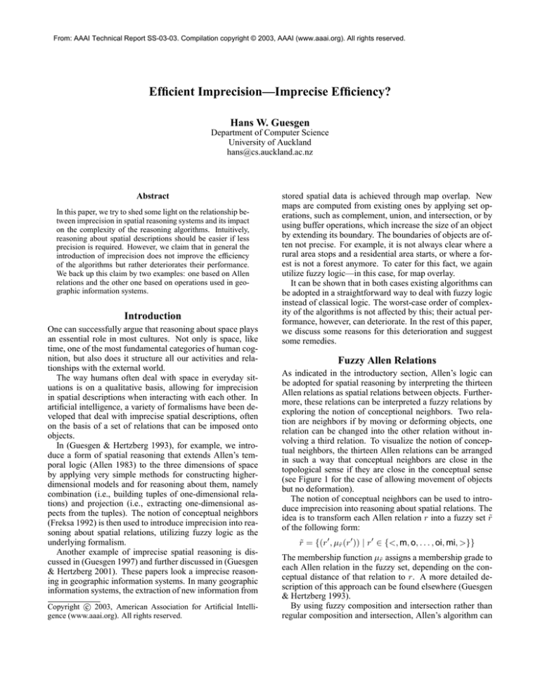
relation can be changed into the other relation without involving a third relation. To visualize the notion of conceptual neighbors, the thirteen Allen relations can be arranged
in such a way that conceptual neighbors are close in the
topological sense if they are close in the conceptual sense
(see Figure 1 for the case of allowing movement of objects
but no deformation).
The notion of conceptual neighbors can be used to introduce imprecision into reasoning about spatial relations. The
idea is to transform each Allen relation r into a fuzzy set r̃
of the following form:
r̃ = {(r , µr̃ (r )) | r ∈ {<, m, o, . . . , oi, mi, >}}
The membership function µr̃ assigns a membership grade to
each Allen relation in the fuzzy set, depending on the conceptual distance of that relation to r. A more detailed description of this approach can be found elsewhere (Guesgen
& Hertzberg 1993).
By using fuzzy composition and intersection rather than
regular composition and intersection, Allen’s algorithm can
<n
mn
sn on fin
dn =n din
fn oin sin
n
mi
>n
Figure 1: Allen’s thirteen atomic relations arranged according to their conceptual neighborhood. Only movement of
objects is considered, no deformation.
• Let R̃ be a set of fuzzy Allen relations between a set of
objects {O1 , O2 , . . . , On }.
• While R̃ is not empty:
1. Select a relation r̃(Oi , Oj ) ∈ R̃
2. R̃ ← R̃ − {r̃(Oi , Oj )}
3. For k ∈ {1, . . . , n} with k = i, j:
r̃(Ok , Oj ) ← r̃(Ok , Oj ) ∩ [r̃(Ok , Oi )◦r̃(Oi , Oj )]
If r̃(Ok , Oj ) changed, then R̃ ← R̃ ∪ {r̃(Ok , Oj )}
r̃(Oi , Ok ) ← r̃(Oi , Ok ) ∩ [r̃(Oi , Oj )◦r̃(Oj , Ok )]
If r̃(Oi , Ok ) changed, then R̃ ← R̃ ∪ {r̃(Oi , Ok )}
Figure 2: Pseudo-code for a fuzzy version of Allen’s algorithm. A term like r̃(Oi , Oj ) denotes the fuzzy Allen relation between the objects that it is referring to. Without loss
of generality, we assume that r̃(Oi , Oj ) is defined for every i, j ∈ {1, 2, . . . , n} with i = j, possibly as universal
relation {(m, 1), (<, 1), (s, 1), . . .}.
be adopted to reason about fuzzy Allen relations. Input to
the algorithm is a set of objects and a set of (not necessarily
atomic) fuzzy Allen relations. The aim of the algorithm is
to transform the given relations into relations that are consistent with each other in the fuzzy sense. This is achieved
through an iterative process that looks at three objects at a
time and applies the composition table to these objects, resulting in new membership grades for the fuzzy relations
(see Figure 2).
The worst-case complexity of the fuzzy algorithm is
O(n3 ), which is the same as the complexity of the original
algorithm. However, unlike in the crisp version of Allen’s algorithm, no elements are deleted from the fuzzy Allen relations during the run of the algorithm (instead, their membership grades are updated). This means that in each composition step, the 13 elements of one fuzzy Allen relation have to
be composed with the 13 elements of the other fuzzy Allen
relation, resulting in 169 table lookups. These table lookups
result in a total of 334 atomic relations (as some table entries
contain more than one relation), each of which is associated
with the minimum of the membership grades of the relations
that led to this relation. From these 334 atomic relations, the
elements are selected whose membership grades are maximal with respect to <, m, o, and so on.
In order to avoid extensive, often redundant, search for the
best relation, two different strategies can be exploited. The
first strategy avoids extensive search by filling relations on a
best-first basis instead of determining the membership grade
of each element in the new fuzzy Allen relation in turn by
first minimizing the pairs and then maximizing results. This
method results from the following considerations:
1. A membership grade of 1 in the composed relation can
only result from combining relations with a membership
grade of 1.
2. The second highest membership grade can only result
from combining relations which have a membership grade
equal to or greater than that membership grade, and so on.
Search is therefore able to stop as soon as a membership
grade has been obtained for each of the 13 Allen relations,
because, by virtue of the heuristic, the first value obtained
must be the maximum.
The second strategy addresses the problem of repeated
lookups. During the composition of two fuzzy Allen relations, the same lookup pair of atomic Allen relations is often produced several times. To avoid that a combination of
relations is looked up more than once, a hash table is maintained in which pairs are recorded that have already been
looked up. Before any two relations are composed, this hash
table can be consulted to ensure an equivalent combination
has not already been processed.
Buffering Fuzzy Raster Maps
The fuzzification of Allen’s algorithm shows that dealing
with imprecision has its price—at least in this case. In the
following, we will discuss another example, which backs up
this claim: fuzzy operations in geographic information systems.
Geographic information systems are information systems that have an emphasis on geographical data structures
(Maguire 1991), such as raster maps (which store data as discrete and regular tessellations of rectangular cells) and vector maps (which store points, arcs and areas as sets of coordinates). Recently, there have been efforts to introduce fuzzy
concepts into geographic information systems (for example,
Altmann’s work on fuzzy clustering and classification (Altmann 1994), Brimicombe’s translator of linguistic hedges
for the handling of uncertainty in GIS (Brimicombe 1997),
Molenaar’s discussion of extensional uncertainty of spatial
objects (Molenaar 1996), Plewe’s look at gradation (Plewe
1997), and our work on fuzzy raster maps (Guesgen 1997;
Guesgen & Hertzberg 2001)).
A fuzzy raster map representation generalizes a traditional
raster GIS by extending discrete categorical values into an
extra dimension, assigning cells a degree of membership
value between 0 and 1 for each category, where only the basic 0 or 1 possibilities would be allowable in a normal GIS
raster. Its purpose is to capture imprecise information and
to provide a framework for approximation in geographical
information systems.
Performing a set operation (complement, union, and intersection) on fuzzy raster maps is straightforward. There are
several ways of defining the complement, union, and intersection of membership functions (Driankov, Hellendoorn, &
Reinfrank 1996), but they all have in common that they are
defined cell-wise for all cells x ∈ L in the fuzzy raster map.
In the case of the original max/min scheme (Zadeh 1965),
the membership functions for the complement, union, and
intersection are defined as follows, where µ1 and µ2 denote
the membership functions of the underlying maps and µ3 the
one of the resulting map:
Complement: ∀x ∈ L : µ3 (x) = 1 − µ1 (x)
Union:
∀x ∈ L : µ3 (x) = max{µ1 (x), µ2 (x)}
Intersection:
∀x ∈ L : µ3 (x) = min{µ1 (x), µ2 (x)}
Since the membership functions for the complement,
union, and intersection are defined cell-wise, an algorithm
for performing a set operation on fuzzy raster maps can just
iterate through the set of cells and compute a new value for
each cell based on the given value(s) for that cell, which
means the algorithm is linear in the number of cells, i.e, its
complexity is O(|L|).
Unlike the set operations, buffer operations cannot be defined cell-wise. They usually involve a number of cells that
are in the same neighborhood, which means that if there is
an area on the map with very high membership grades, then
a buffer operation should assign high membership grades to
cells that are very close to that area, medium high membership grades to cells close to the areas, and low membership
grades to cells further away.
One way to achieve this behavior is to determine the direct
neighbors of a cell x0 and to apply a buffer function β to
determine the new membership grade of these neighbors:
µ(x1 ) ← max{µ(x1 ), β(µ(x0 ))}
A buffer function is a monotonically increasing function
from the unit interval into itself that satisfies the following
condition:
∀m ∈ [0, 1] : β(m) ≤ m
Since updating the membership grade of x1 can have an impact on the membership grades of the neighbors of x1 , the
update process has to be repeated for all cells of the map
over and over again until a stable situation is obtained.
A brute-force algorithm for buffering a fuzzy raster map
visits each cell of the map and updates its membership grade
based on the membership grades of the neighboring cells. If
any of the membership grades is changed, the algorithm repeats the updating process until all membership grades become stable. Since the algorithm revisits each cell when repeating the updating process, even the ones whose neighbors
have not been changed in the previous iteration, it performs
many unnecessary checks.
An improved algorithm keeps track of the changed cells
and revisits a cell only if at least one of its neighbors has
been changed. This is achieved by applying the principle of
local propagation: the membership grade of a cell is propagated to the neighbors of the cell, which are then put onto
the list of cells to be visited in the future.
The local propagation algorithm is guaranteed to terminate, since there is only a finite number of cells and therefore only a finite number of membership grades. The transitive closure of the neighborhood relation is also finite, which
means that the buffer operation is applied a finite number of
times to a finite number of values. Therefore, the number
of new membership grades is limited and with that the number of possible changes. Since cells are only put back onto
the list of cells to be revisited if the membership grade has
changed, this list must eventually become empty.
Although the propagation algorithm is guaranteed to terminate, it may take a large number of cells to be revisisted
before the list of cells finally becomes empty, the reason being that it is always possible for a cell to receive a larger
membership grade because of the buffer operation. To prevent this from happening, we can select a cell from the list
with a maximum membership grade. The grade for such
a cell cannot be increased by any buffer operation β(m),
since β(m) ≤ m for all m ∈ [0, 1], and therefore buffering
the neighbors of a cell with maximum membership grade results in assigning a final membership grade to the neighbors
of that cell. This means that none of the neighbors have to
be revisited.
In addition to the algorithms sketched above, a range of
other algorithms have been developed, including the following:
• Algorithms for global buffering, which take more than
just direct neighbors into consideration when determining
the new membership grade of a cell.
• Hardware-based algorithms that use the z-buffer of graphics cards to buffer fuzzy maps.
• Source-cell memory algorithms, which for each cell keep
track of the currently highest membership grade and its
origin.
The result of this endeavor are algorithms whose behavior is
almost always linear in the number of cells (and quadratic
in the worst case). Details about these results can be found
elsewhere (Duff & Guesgen 2002).
Summary
A first naive thought might be that things become easier when moving from precise reasoning to fuzzy reasoning about spatial information. However, this is not always
the case, as this paper tries to show by providing some
counterexamples. These examples include an extension of
Allen’s algorithm for reasoning about fuzzy relations and a
discussion of a number of algorithms for reasoning about
fuzzy raster maps.
References
Allen, J. 1983. Maintaining knowledge about temporal
intervals. Communications of the ACM 26:832–843.
Altmann, D. 1994. Fuzzy set-theoretic approaches for handling imprecision in spatial analysis. International Journal
of Geographical Information Systems 8(3):271–289.
Brimicombe, A. 1997. A universal translator of linguistic
hedges for the handling of uncertainty and fitness-of-use
in GIS. In Kemp, Z., ed., Innovations in GIS 4. London,
England: Taylor and Francis. 115–126.
Driankov, D.; Hellendoorn, H.; and Reinfrank, M. 1996.
An Introduction to Fuzzy Control. Berlin, Germany:
Springer, 2nd edition.
Duff, D., and Guesgen, H. 2002. An evaluation of buffering
algorithms in fuzzy GISs. In Proc. International Conference on Geographic Information Science (GIScience-02),
80–92. Published as Lecture Notes in Computer Science
2478 by Springer, Berlin.
Freksa, C. 1992. Temporal reasoning based on semiintervals. Artificial Intelligence 54:199–227.
Guesgen, H., and Hertzberg, J. 1993. A constraint-based
approach to spatiotemporal reasoning. Applied Intelligence
(Special Issue on Applications of Temporal Models) 3:71–
90.
Guesgen, H., and Hertzberg, J. 2001. Algorithms for
buffering fuzzy raster maps. In Proc. FLAIRS-01, 542–
546.
Guesgen, H. 1997. On fuzzy geographic information systems. In Proc. FLAIRS-97, 155–160.
Maguire, D. 1991. An overview and definition of GIS.
In Maguire, D.; Goodchild, M.; and Rind, D., eds., Geographical Information Systems: Principles and Applications. Essex, England: Longman Scientific & Technical.
21–43.
Molenaar, M. 1996. The extensional uncertainty of spatial
objects. In Proc. SDH-96, 9B.1–13.
Plewe, B. 1997. A representation-oriented taxonomy of
gradation. In Hirtle, S., and Frank, A., eds., Spatial Information Theory: A Theoretical Basis for GIS, Lecture Notes
in Computer Science 1329. Berlin, Germany: Springer.
121–136.
Zadeh, L. 1965. Fuzzy sets. Information and Control
8:338–353.


