CURRENT SCIENCE GUEST EDITORIAL
CURRENT SCIENCE
Volume 106 Number 3 10 February 2014
GUEST EDITORIAL
Warming causes cooling! The recent cold event over North America
January 2014 would have been largely an uneventful month for the average American but for events that made him/her shiver. Many parts of USA recorded low temperatures between 5 and 7 January 2014 and also during the last week of January. Parts of USA at mid-latitudes experienced snowfall after many years. In short, life became more chaotic than usual. A day previous to this event, the temperature in New York City was a balmy
11
°
C. The next day it had plunged to a frigid –15
°
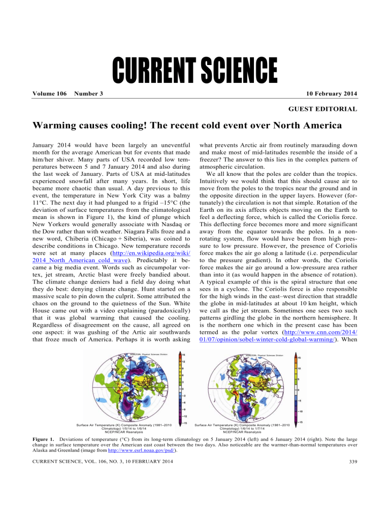
C (the deviation of surface temperatures from the climatological mean is shown in Figure 1), the kind of plunge which
New Yorkers would generally associate with Nasdaq or the Dow rather than with weather. Niagara Falls froze and a new word, Chiberia (Chicago + Siberia), was coined to describe conditions in Chicago. New temperature records were set at many places ( http://en.wikipedia.org/wiki/
2014_North_American_cold_wave ). Predictably it became a big media event. Words such as circumpolar vortex, jet stream, Arctic blast were freely bandied about.
The climate change deniers had a field day doing what they do best: denying climate change. Hunt started on a massive scale to pin down the culprit. Some attributed the chaos on the ground to the quietness of the Sun. White
House came out with a video explaining (paradoxically) that it was global warming that caused the cooling.
Regardless of disagreement on the cause, all agreed on one aspect: it was gushing of the Artic air southwards that froze much of America. Perhaps it is worth asking what prevents Arctic air from routinely marauding down and make most of mid-latitudes resemble the inside of a freezer? The answer to this lies in the complex pattern of atmospheric circulation.
We all know that the poles are colder than the tropics.
Intuitively we would think that this should cause air to move from the poles to the tropics near the ground and in the opposite direction in the upper layers. However (fortunately) the circulation is not that simple. Rotation of the
Earth on its axis affects objects moving on the Earth to feel a deflecting force, which is called the Coriolis force.
This deflecting force becomes more and more significant away from the equator towards the poles. In a nonrotating system, flow would have been from high pressure to low pressure. However, the presence of Coriolis force makes the air go along a latitude (i.e. perpendicular to the pressure gradient). In other words, the Coriolis force makes the air go around a low-pressure area rather than into it (as would happen in the absence of rotation).
A typical example of this is the spiral structure that one sees in a cyclone. The Coriolis force is also responsible for the high winds in the east–west direction that straddle the globe in mid-latitudes at about 10 km height, which we call as the jet stream. Sometimes one sees two such patterns girdling the globe in the northern hemisphere. It is the northern one which in the present case has been termed as the polar vortex ( http://www.cnn.com/2014/
01/07/opinion/sobel-winter-cold-global-warming/ ). When
Surface Air Temperature (K) Composite Anomaly (1981–2010 Surface Air Temperature (K) Composite Anomaly (1981–2010
Climatology) 1/5/14 to 1/6/14
NCEP/NCAR Reanalysis
Climatology) 1/6/14 to 1/7/14
NCEP/NCAR Reanalysis
Figure 1. Deviations of temperature (
°
C) from its long-term climatology on 5 January 2014 (left) and 6 January 2014 (right). Note the large change in surface temperature over the American east coast between the two days. Also noticeable are the warmer-than-normal temperatures over
Alaska and Greenland (image from http://www.esrl.noaa.gov/psd/ ).
CURRENT SCIENCE, VOL. 106, NO. 3, 10 FEBRUARY 2014 339
GUEST EDITORIAL
we examine a typical wind pattern, we notice that the air flow is not strictly in the east–west direction. There is a meander in this jet stream. At some places it goes northwards and at others it goes southwards. If the flow was strictly in the east–west direction, air-masses from the tropics and the polar regions would never have mixed.
However, these meanders allow eddies (large whirls) to form. In these eddies the warm and cold air masses mix and create unstable weather. Wherever the meander is towards the north, warm air moves in and temperatures rise; and over a region where the meander is to the south, cold Arctic air rushes southwards and we witness the cold snaps. Even during the current cold outbreak, there were large regions (Greenland, parts of Europe and Alaska;
Figure 1) which experienced warmer-than-normal weather.
What caused the present outbreak to be so strong? Was it part of natural variability or were there extraneous factors? As we have seen, temperature (and pressure) gradients in the north–south direction play a major role in maintaining the flow of cold air encircling the Arctic and preventing it from moving into mid-latitudes. If these temperature gradients were reduced, then the jet-stream would meander more. More meanders imply more eddies and more frequent cold-air outbreaks. In the context of the present event, we find that there was Sudden Stratospheric Warming (SSW), ( http://en.wikipedia.org/wiki/
2014_North_American_cold_wave ). During an SSW, stratospheric temperature in the lower stratosphere
(around 50 hPa) can increase by tens of Celsius in a few days. Such a dramatic warming can change the gradients of temperature in the stratosphere and hence affect the flow patterns in the stratosphere and troposphere. The warmer stratospheric air comes down and cleaves the polar jet, allowing for southward movement of the cold air mass. During an SSW, the polar jet slows down and sometimes reverses its direction, leading to eddies.
It has also been observed in the last few decades that polar regions have been warming up faster than the tropical regions. Trapping of heat due to increased greenhouse gases can cause the polar ice to melt. This reduces reflectivity, which in turn allows more energy to be absorbed, leading to faster warming in the polar regions. The tropics in contrast have little ice and hence the effect here is less pronounced. This results in a reduction of the temperature gradient, which leads to more meanders and more frequent outbreaks. The current cold snap could be a manifestation of this. However not all scientists subscribe to this theory of cold-air outbreak. Adam Sobel
( http://www.cnn.com/2014/01/07/opinion/sobel-wintercold-global-warming/ ), a scientist who accepts anthropogenic climate change to be real says: ‘I don’t think the research to date justifies such a conclusion. But the research on both sides is all still new and hotly debated.
Events like the current one highlight some of what we still don’t understand about the relationship of long-term climate changes to short-term extreme weather.’ He further notes that November 2013 was the warmest month on record (on the global scale), which clearly indicates that global warming has not disappeared.
Some have attributed the current cold snap to solar activity. The current behaviour of the Sun has mystified many. Presently, sun-spot activity should have been at its peak (if one goes by sun-spot cycles). However, the current activity is much weaker than in previous cycles
( http://www.newscientist.com/article/dn24512-solar-activity-heads-for-lowest-low-in-four-centuries.html
). Variations in solar activity can change the ultra-violet radiation received (and hence absorbed in the stratosphere). This changes the stratospheric temperature gradients and the tropospheric circulation. Some have seen an association between jet-stream strength and solar activity. Peak of solar activity (in the present case, it is supposedly at a peak though the magnitude is subdued) in conjunction with westward phase of Quasi Biennial Oscillation (QBO, an oscillation of the wind in the tropical stratosphere, the current phase is westerly; http://www.cpc.ncep.noaa. gov/products/CDB/Tropics/figt3.gif
) is associated with increased SSW which could result in disruption of the polar vortex and lead to more extreme weather events (Gray et al ., Reviews in Geophysics , 2010, 48 , RG4001). Also, one needs to note that they are discussing probability of occurrence of SSW and not about a single event. They also suggest that in recent years the signal from greenhouse gases could be much stronger than from solar variability.
Another question generally asked about such an extreme event is whether the forecasting agencies were able to predict these events in advance and if the disaster management agencies were well prepared? The forecasting agencies had seen the event coming and most agencies seem to have been well prepared for the event.
Inevitably it led to shutdown and disruption of flight schedules, but these cannot be avoided given the magnitude of the event.
While one is able to forecast these events at a short timescale, it is difficult to pin down the cause to a single factor. Given that the climate system is complex, the cause for such an event could be a combination of factors. Hence it would be inappropriate to deny anthropogenic climate change (a long-term trend) just because of such an event. Perhaps one needs to remember the old
English proverb (attributed to Aristotle): ‘one swallow does not a summer make’. Interestingly, Wiktionary
( http://en.wiktionary.org/wiki/one_swallow_does_not_a_ summer_make ) translates this into plain English as: ‘one instance of an event does not necessarily indicate a trend’. Perhaps there lies the message.
Ravi S. Nanjundiah
Centre for Atmospheric and Oceanic Sciences,
Indian Institute of Science,
Bangalore 560 012, India e-mail: ravi@caos.iisc.ernet.in
340 CURRENT SCIENCE, VOL. 106, NO. 3, 10 FEBRUARY 2014
