From: FLAIRS-02 Proceedings. Copyright © 2002, AAAI (www.aaai.org). All rights reserved.
SpaceCAPS: Automated Mission Planning for the TechSat 21 FormationFlying Cluster Experiment
John L. Mohammed
Stottler Henke Associates, Inc.
1660 South Amphlett Boulevard, Suite 350
San Mateo, California 94402
mohammed@shai.com
Abstract
This paper describes a project concerned with the
development of a mission planning system to provide
automated planning assistance for the Air Force TechSat 21
formation-flying satellite cluster experiment: Spacecraft
Cluster Automatic Planner/Scheduler (SpaceCAPS). The
project’s focus is on planning and scheduling for payload
management, but the system serves as a central planning
system for planning and scheduling of all spacecraft
functions. The paper describes some of the planning and
scheduling requirements for cluster payload management,
and describes a system for optimization of the mission plan
for the TechSat 21 space-based radar surveillance system.
Introduction
A satellite cluster is a group of satellites that fly within
very close range of each other (e.g., 250m-5km). These
satellites coordinate their activities, so that they can use
sparse array interferometry and synthetic aperture
techniques to simulate a single, very large satellite. The
cluster operates as a “virtual” satellite with a very large
effective aperture, without the need for the heavy
infrastructure that would be required to have a monolithic
satellite with the equivalent aperture. The cluster approach
has many advantages over a single large satellite:
• Each spacecraft is smaller, lighter, simpler, and
simpler to manufacture;
• Economies of scale enable a cluster of many
satellites to be less expensive to manufacture than
a single satellite;
• The cluster can adapt to the failure of any
individual satellites, and failed satellites can be
incrementally replaced;
• The cluster can reconfigure the orbits of the
satellites in the cluster to optimize for different
missions.
Copyright © 2002, American Association for Artificial Intelligence
(www.aaai.org). All rights reserved.
24
FLAIRS 2002
A constellation of clusters would enable whole-earth
coverage from low earth orbit and/or continuous coverage
for specific theatres. However, clusters and constellations
present a significant challenge to current methods for the
management of space-based assets. Current practices are
too labor-intensive and would not scale well to the large
numbers of satellites that would have to be managed.
Automation will have to play a much larger role in
planning and operations, and tools for automation will
have to be knowledgeable about the unique characteristics
of the formation-flying satellite cluster. The number of
satellites to be managed, and the wider range of parameters
that can be optimized demand new tools for planning,
scheduling and optimization.
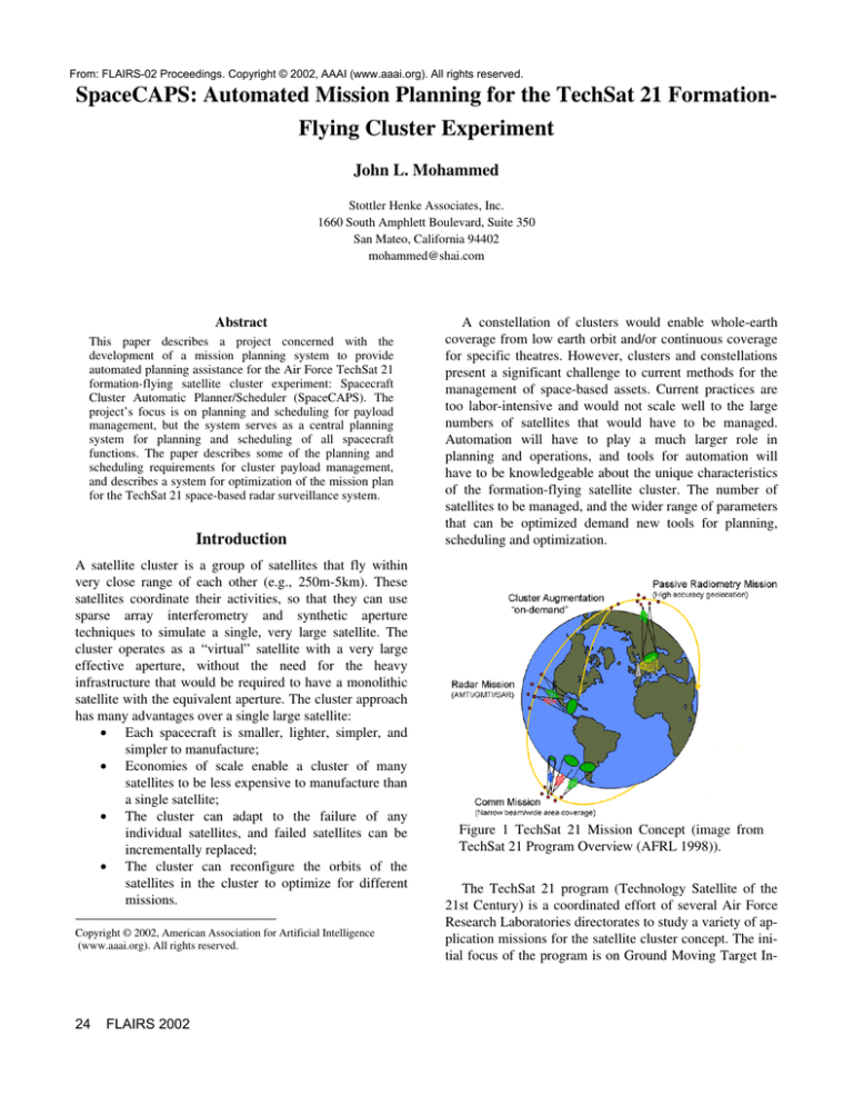
Figure 1 TechSat 21 Mission Concept (image from
TechSat 21 Program Overview (AFRL 1998)).
The TechSat 21 program (Technology Satellite of the
21st Century) is a coordinated effort of several Air Force
Research Laboratories directorates to study a variety of application missions for the satellite cluster concept. The initial focus of the program is on Ground Moving Target In-
dication (GMTI) , Synthetic Aperture Radar (SAR) imaging, formation-flying, and on-board autonomy.
Each micro-satellite in the cluster transmits radar pulses
that are orthogonal to those transmitted by every other satellite in the cluster, and each detects and coherently combines the returns from every satellite in the cluster. In this
way, the micro-satellites in the cluster form a large but
sparse coherent array, enabling collection of angle- and
time-of-return data with an effective aperture equivalent to
the separation between the micro-satellites.
The vision for the deployed system is a constellation of
“virtual” satellites, with each virtual satellite being a cluster of micro-satellites. The numbers are still to be determined, but according to one published account (Martin and
Stallard 1999) there would be 35 virtual satellites and 5
spare virtual satellites. Each cluster would contain eight
micro-satellites flying within 250 meters of each other.
The constellation size is motivated by a desire for fullearth coverage and/or continuous coverage in two theatres.
The number and spacing of the micro-satellites in each
cluster is motivated by performance requirements for the
GMTI mission. Other proposals mention cluster sizes up to
16 micro-satellites, and other missions (such as passive
geolocation) require larger separations (up to 5km).
A one-year technology demonstration flight is planned
for launch in November 2004. This flight will consist of
one cluster of only three micro-satellites. This single cluster will reconfigure the orbits of its micro-satellites for different phases of its mission, which will test different mission applications.
This paper reports on an on-going project concerned
with developing an automated planning assistance system
for mission planning for the TechSat 21 flight experiment.
Although this will experimental software developed
through a research program, the intention is that it will be
used operationally during the flight experiment.
Payload Schedule Optimization
The initial focus of the ground-based mission planner is
optimization of the quantity and quality of observations
that can be made during the entire mission life, taking into
account detailed constraints regarding resource usage,
viewing geometry, downlink opportunities and bandwidth,
and interactions with bus activities. The planner creates a
detailed schedule that attempts to maximize the number of
target observations and the quality of the observations
while distributing the observations as evenly as possible
among all the identified targets according to preference.
Target Selection
Scheduling for any satellite whose mission involves observations of and/or communication with the ground must
take into account “accesses”—windows of opportunity defined by when the satellite is in view of the target on the
ground. These are determined by the precise orbit that the
satellite is in. For satellite clusters, one must also take the
relative positions of the individual satellites into account
when assessing viewing geometry.
Satellites cannot fly side-by-side in close formation
without expending a great deal of fuel. “Formation-flying”
satellites actually fly in closely related stable orbits. Unless
the satellites are flying directly behind one another, the
only stable orbits involve relative elliptical motion. Thus,
the geometric configuration of the satellites is in constant
periodic flux. When an observation requires coordinated
action by all satellites in the cluster, not only must all the
satellites be in view of the target at the same time, but also
their relative positions should satisfy the requirements for
good observational geometry.
The mission planner must also use a performance
predictor to decide which targets should be observed and
when. There will often be several targets in a position to be
observed at close to the same time. However, resource
constraints will limit the number of targets that can be observed. For the demonstration flight especially, the objective will be to maximize both the number and quality of
the observations made. This implies that the planner must
select the targets to observe based on the predicted performance.
The performance predictor will be determined by a set
of constraints specified by the payload experts for each
type of observation. Go/no-go constraints will be used to
filter out access opportunities for which there is little or no
hope of a good observation. Figure of merit constraints
will provide a means to compare the predicted observation
quality for any two access opportunities.
Ephemeris Uncertainty
Spacecraft ephemeris will play a significant role in
determining both exactly when target accesses are
possible, and the figure of merit for the observation.
Unfortunately, the spacecraft ephemeris cannot be
predicted with the required degree of accuracy very far
into the future.
This implies that the long-term plans made by the
planner must be revisited and adjusted within a short
interval (e.g., 72 hours or less) before each observation.
Thus, one function of the mission planner will be to
periodically compute updates to its plans as more accurate
ephemeris data becomes available.
Downlinks
Synthetic aperture radar techniques generate very large
amounts of data (the same is true for hyperspectral
instruments). For example, the TechSat 21 micro-satellite
FLAIRS 2002
25
(in a cluster with two other satellites) collects 9.6 Gigabytes (GB) per satellite for a two-minute observation. With
overhead, this means that the total amount of data that
must be downlinked from all three satellites is 33.5 GB. At
the expected downlink bandwidth of 150 Mbps, this will
take approximately 32 minutes. In low earth orbit, the
micro-satellites are in view of a ground station for approximately four minutes at a time, about four times a day. This
means it can take two days to downlink the data from one
two-minute observation (AFRL, 2000).
Thus, onboard memory capacity, downlink accesses and
downlink bandwidth are the constraints that most limit the
number of experiments that can be performed. The mission
planner must select the ground station for each downlink
taking care to observe constraints regarding contention for
ground station resources.
Downlink Uncertainty
The situation is further complicated by the fact that
whereas payload data will be downlinked via X-band
communications with a commercial ground station, state of
health downlinks and command uplinks will be
communicated using S-band communications via the Air
Force Satellite Control Network (AFSCN).
Thus, when payload data are downlinked, the memory
they occupy onboard cannot be freed for reuse until the
next contact opportunity with an AFSCN ground station,
when the quality of the downlinked data can be verified.
Not only are the X-band and S-band ground stations
located in geographically distinct places, but there is a high
degree of uncertainty regarding which AFSCN ground
station will make the contact.
There are sufficient AFSCN ground stations that the
satellites could be contacted several times a day. However,
as an experiment, the TechSat 21 flight assumes a low
priority in comparison with the operational satellite
systems managed by AFSCN. The AFSCN performs a
resource allocation determination on a daily basis. As a
result, the TechSat 21 mission operations center will not
know which potential contacts will actually occur until 24
hours before they happen.
This implies that the mission planner must allow for a
high degree of uncertainty regarding when on-board
resources will be released.
Mission Operations Center
The TechSat 21 flight experiment will be managed from a
Mission Operations Center currently under development at
AFRL Phillips Site in Kirtland AFB. All planning and
scheduling functions will be coordinated through the
Mission Planning Workstation (MPW) which will be
running
the
Spacecraft
Cluster
Automatic
26
FLAIRS 2002
Planner/Scheduler (SpaceCAPS) software. Figure 2 shows
the workstations with which the MPW will interface.
TT&C
Data Center
Mission Planning
Flight Dynamics
Payload PIs
Figure 2. Mission Planning Workstation Interfaces
The Flight Dynamics workstation (FDW) will be used to
track the space vehicles’ orbits, perform orbit prediction,
and plan both formation-keeping and formation-changing
maneuvers. The MPW will obtain the ephemeris data it
needs to perform its planning function by linking to a
COTS orbit–propagation tool (Satellite ToolKit from
Analytical
Graphics,
Inc.)
running
on
that
workstation.When the flight dynamics experts determine
that a maneuver will be necessary, they will use the
MPW’s remote GUI to submit a demand that the
maneuver be inserted into the schedule. Such demands will
take precedence over observation requests.
The Telemetry, Tracking & Commanding (TT&C)
workstation will take responsibility for processing the
telemetry and tracking data obtained from the ground
station, perform engineering analysis (including trending)
on this data, and monitor the spacecraft state of health. It
will also generate the command uploads to the spacecraft.
The MPW will obtain state of health data affecting its
planning and scheduling from the TT&C workstation. It
will submit its plans to the TT&C workstation as a
sequence of events, expressed as high-level procedure in
the Satellite Control Language (SCL) from Interface &
Control Systems, Inc. The SCL system will expand the
event sequence into the set of low-level satellite commands
needed to carry out the plan, and submit these for upload
to the ground station.
As the TT&C workstation determines that housekeeping
activities need to be executed, these will be submitted to
the MPW for inclusion in the schedule.
All communication between the MPW and the TT&C
workstation will use the SCL message-passing protocol
called the Software Bus
The payload experts will employ the MPW’s remote
GUI to submit requests to schedule observations. These
requests will include specification of the payload
constraints that determine viability and predicted value of
each observation. The MPW will attempt to schedule as
many of these observations as possible, subject to resource
contention between the observations and between them
and the formation-flying and housekeeping activities that
are to be scheduled. The payload experts can use the MPW
remote GUI to review the proposed schedules. It may not
be possible to determine some payload configuration
settings until the activity has been scheduled and the
observation geometry has been determined. Furthermore, it
may not be possible to automate the generation of these
settings. Thus, the MPW remote GUI will also enable the
payload experts to manually specify these settings before
the schedule is submitted for uplink.
The Data Center is not technically part of the MOC.
This workstation has a high-volume RAID disk system
that will be used to provide organized storage of all the
experiment data, telemetry data and configuration data.
The Data Center will provide access to some of this data to
offsite consumers via the internet. The MPW interfaces
with the Data Center both to store the plans and schedules
it creates, and to obtain current values for parameters
affecting scheduling that characterize the spacecraft
behavior, such as battery charge and discharge rates and
slew times.
SpaceCAPS Mission Planner
The SpaceCAPS Mission Planner employs the
Automated Scheduling and Planning Environment
(ASPEN) system developed at JPL (Chien, 2000).
SpaceCAPS encapsulates the ASPEN system within a
Schedule Server that provides all the interfaces to the other
workstations, including the Remote GUI.
The server performs some preprocessing of the activity
requests (e.g., to use the payload go/no-go constraints to
weed out potential observations). It also converts the
emphemeris data obtained from the FDW into a sequence
of activity requests for each access window. It provides
heuristic functions to help control ASPEN’s search
process. It provides an access control mechanism that
ensures that only authorized personnel can modify
schedules and sanction them for upload to the satellites.
Finally, it provides new way of viewing the schedules that
emphasizes relationships between activities and the
resources they employ.
Status
The SpaceCAPS mission planner is currently under
development. It is now in Phase II of a Small Business
Innnovative Research (SBIR) project.
We have demonstrated that we can obtain ephemeris
and access window data from STK on the FDW via
STK/Connect, obtain parameters from the Data Center and
incorporate them into the ASPEN activity models, drive
ASPEN to produce spacecraft schedules, convert the
schedules to SCL scripts, archive the schedules in the Data
Center, and communicate these scripts to the TT&C
workstation via the Software Bus for upload to the
spacecraft.
Remaining efforts will concentrate on design and
development of the Remote GUI, and improvement of the
ASPEN activity models and search heuristics.
Conclusions
Formation-flying clusters of micro-satellites have several
technical and economic advantages over monolithic satellites, but they also pose new technical challenges. Among
these is the need for increased automation in mission planning and operations, and the need for planning and scheduling systems to be aware of new constraints and optimization criteria particular to cluster management. The SpaceCAPS project is identifying these new constraints and developing techniques to address them.
Acknowledgements
The author gratefully acknowledges the assistance provided by Charles Earl, Lance Self, Paul Zetocha, Ross
Wainwrigth, Steve Fiedler, David Martin, and Maurice
Martin. The work reported in this paper was supported by
SBIR Phase II contract number F29601-01-C-0035
awarded by AFRL.
References
AFRL, 1998. TechSat 21 Program Overview. Air Force
Research Laboratories Space Vehicles Directorate.
http://www.vs.afrl.af.mil/VSD/TechSat21/.
AFRL, 2000. TechSat 21 Command, Control and Communications Planning Document, V1.01 (Draft), May 2000.
Chien, S., G. Rabideau, R. Knight, R. Sherwood, B.
Engelhardt, D. Mutz, T Estlin, B. Smith, F. Fisher, T.
Barrett, G. Stebbins, and D. Tran , “ASPEN – Automating
Space Mission Operations using Automated Planning and
Scheduling,” SpaceOps 2000, Toulouse, France, June
2000.
Martin, M. and Stallard, M.J., 1999. Distributed Satellite
Missions and Technologies — The TechSat 21 Program.
In Proceedings of the 1999 AIAA Space Technology Conference and Exposition, Albuquerque, NM, 28–30 September 1999. AIAA-99-4479.
FLAIRS 2002
27


