From: AAAI-00 Proceedings. Copyright © 2000, AAAI (www.aaai.org). All rights reserved.
Qualitative Spatial Interpretation of Course-of-Action Diagrams
Ronald W. Ferguson*
ferguson@cs.nwu.edu
‡
Robert A. Rasch, Jr.
William Turmel*
Kenneth D. Forbus*
raschr@leavenworth.army.mil
turmel@ils.nwu.edu
forbus@ils.nwu.edu
‡
*Qualitative Reasoning Group
Computer Science Department, Northwestern University
Evanston, IL 60201, USA
This paper describes two reasoners built for a real-world
diagrammatic reasoning task: Course-of-Action (COA)
diagrams. COA diagrams are a useful test bed for diagrammatic reasoning due to their inherently spatial domain and
extensible visual symbology. Using a qualitative spatial
reasoning engine, GeoRep, we built two COA diagram
interpreters. We first describe COA diagrams, then the
GeoRep engine, and then the resulting COA interpreters.
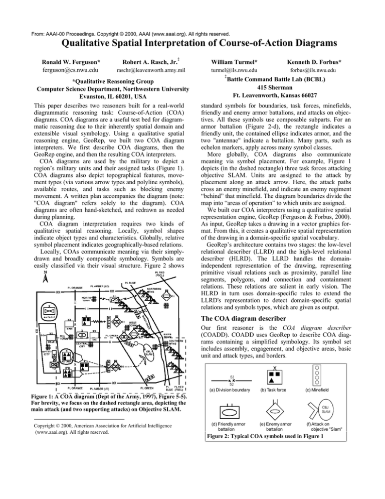
COA diagrams are used by the military to depict a
region’s military units and their assigned tasks (Figure 1).
COA diagrams also depict topographical features, movement types (via various arrow types and polyline symbols),
available routes, and tasks such as blocking enemy
movement. A written plan accompanies the diagram (note:
"COA diagram" refers solely to the diagram). COA
diagrams are often hand-sketched, and redrawn as needed
during planning.
COA diagram interpretation requires two kinds of
qualitative spatial reasoning. Locally, symbol shapes
indicate object types and characteristics. Globally, relative
symbol placement indicates geographically-based relations.
Locally, COAs communicate meaning via their simplydrawn and broadly composable symbology. Symbols are
easily classified via their visual structure. Figure 2 shows
Battle Command Battle Lab (BCBL)
415 Sherman
Ft. Leavenworth, Kansas 66027
standard symbols for boundaries, task forces, minefields,
friendly and enemy armor battalions, and attacks on objectives. All these symbols use composable subparts. For an
armor battalion (Figure 2-d), the rectangle indicates a
friendly unit, the contained ellipse indicates armor, and the
two "antennae" indicate a battalion. Many parts, such as
echelon markers, apply across many symbol classes.
More globally, COA diagrams also communicate
meaning via symbol placement. For example, Figure 1
depicts (in the dashed rectangle) three task forces attacking
objective SLAM. Units are assigned to the attack by
placement along an attack arrow. Here, the attack paths
cross an enemy minefield, and indicate an enemy regiment
“behind” that minefield. The diagram boundaries divide the
map into “areas of operation” to which units are assigned.
We built our COA interpreters using a qualitative spatial
representation engine, GeoRep (Ferguson & Forbus, 2000).
As input, GeoRep takes a drawing in a vector graphics format. From this, it creates a qualitative spatial representation
of the drawing in a domain-specific spatial vocabulary.
GeoRep’s architecture contains two stages: the low-level
relational describer (LLRD) and the high-level relational
describer (HLRD). The LLRD handles the domainindependent representation of the drawing, representing
primitive visual relations such as proximity, parallel line
segments, polygons, and connection and containment
relations. These relations are salient in early vision. The
HLRD in turn uses domain-specific rules to extend the
LLRD's representation to detect domain-specific spatial
relations and symbols types, which are given as output.
The COA diagram describer
Our first reasoner is the COA diagram describer
(COADD). COADD uses GeoRep to describe COA diagrams containing a simplified symbology. Its symbol set
includes assembly, engagement, and objective areas, basic
unit and attack types, and borders.
(a) Division boundary
(b) Task force
Figure 1: A COA diagram (Dept of the Army, 1997), Figure 5-5).
For brevity, we focus on the dashed rectangle area, depicting the
main attack (and two supporting attacks) on Objective SLAM.
Copyright © 2000, American Association for Artificial Intelligence
(www.aaai.org). All rights reserved.
(c) Minefield
2%6/$0
(d) Friendly armor
battalion
(e) Enemy armor
battalion
(f) Attack on
objective "Slam"
Figure 2: Typical COA symbols used in Figure 1
HLRD rules are used to recognize COA symbols using
low-level relations. For example, friendly armor units are
recognized as rectangles containing horizontally-oriented
ellipses. These rules reflect the compositionality of COA
symbols. For example, echelon markers are detected and
then linked to specific units and boundaries, reflecting how
echelon markers apply across different symbol types. Other
rules infer unit intent by proximity to attack arrows and
assembly areas. The rule set is small but expressive, with
37 HLRD rules covering 18 object types and relations.
To test COADD, we built a COA retriever. We used
MAC/FAC (Forbus, Gentner, & Law, 1995), a retriever
based on the Structure-Mapping Theory of similarity
(Gentner, 1983), as the retrieval engine. Given a target
diagram, COADD built a description and MAC/FAC
retrieved the most similar COA diagram, using a casebase
of previously-built descriptions.
Preliminary testing with a casebase of 10 cases showed
that performance was adequate, but not exceptional: similar
cases were often retrieved (e.g., for simple attack plans),
and the aligned parts were often useful, but the depth of
COADD’s simplified domain did not provide enough
variability for proper testing. Useful test results required a
broader subset of the COA symbology.
The COA Geographic Reasoner
In our second prototype (which was designed for the
DARPA HPKB initiative), attempts to expand the COADD
prototype soon made clear that a deeper revision was
needed. A broader symbology and larger diagrams made
COADD’s recognition difficult and slow.
First, GeoRep's input was changed to use knowledgeenriched vector graphics. This format contains primitive
visual elements as before, but also links visual elements to
specific COA objects—in effect pre-classifying them.
Identified symbols are handled by a glyph visual element,
which contains component shapes that have display
characteristics, extent, and location, but are not analyzed by
GeoRep’s low-level vision routines. For example, while
GeoRep previously had to recognize armor battalions, the
input now specifies which visual elements are armor
battalions. This leaves the more tractable task of
representing geographic relations between glyphs.
In collaboration with other HPKB research teams, we
determined a set of 15 geographic queries. These queries
emphasize relative distance and direction, areas of
operation, paths, and metric distance measures.
The resulting geographic reasoner answers a broad set of
queries, and was used successfully by other research teams
to build a knowledge-based COA critiquer. In our testing,
the reasoner handled 190 geographic queries over four
different COA diagrams and answered all but 8 correctly.
While the system is powerful, the visual domain theory is
small, containing 51 axiomatic rules and 23 base statements
(categories and category relations) for 15 query types.
The geographic reasoner combines spatial and semantic
knowledge to determine critical relationships. Figure 3
shows several of its queries and answers. Its answers show
Units A, B, and C are friendly units in the dotted region of
Figure 1. Unit Z is the enemy unit to their right.
What is a path between friendly unit B and enemy unit Z?
How far apart are they along that path? Path-880 (a path
between the units). 2.96 km.
What obstacles are between unit B and enemy unit Z? How
far from unit B to the obstacle along that previous path?
What is the ordinal direction from unit B to the obstacle?
Minefield-84. 2.12 kilometers. East—directly.
What is the area of operations for unit A? Answer returns an
area, bounded by brigade-level borders, around unit A.
What is the area of operations for unit B? Same area, located
east of the unit. Unit B is outside this area, but Unit B’s task
is inside, meaning that it is unit B’s responsibility.
Figure 3: Questions and answers to the Geographic
Reasoner for Figure 1, re-written in English.
a clean interaction between knowledge about the glyphs
("Which glyphs are minefields?"), semantic categories
("Are minefields an obstacle?") and qualitative spatial
relations ("Is there an obstacle between this unit and its
goal?"). Often “spatial” relationships turn on conceptual
knowledge ("Is this unit a part of the area of operations it is
inside? Only if its task’s goal is not elsewhere.").
Conclusion
COA diagrams constitute a useful test bed for research into
diagrammatic reasoning. Using a two-level qualitative
spatial reasoner like GeoRep, one can quickly build
powerful diagrammatic reasoners.
There are many limitations in the current prototypes. The
difficulty with scaling COADD is telling, and highlights the
difficult task of distinguishing between many similar glyph
types. While the Geographic Reasoner works well, its
query set is limited. In addition, performance is sometimes
slow due to inefficiencies in proximity-detection.
Development continues. We hope to extend the low-level
visual vocabulary to clarify COADD’s scaling difficulties.
We also plan to extend the Geographic Reasoner, adding
query types and increasing reasoner efficiency. This system
is currently being evaluated for integration into a prototype
COA decision support system.
Acknowledgments. This research was supported by the
DARPA High Performance Knowledge Bases initiative, by
the Office of Naval Research’s Cognitive and Computer
Science programs, and by the National Science Foundation
under the Learning and Intelligent Systems program.
References
Department of the Army. (1997). Staff Organizations and
Operations (Field Manual 101-5). Washington, DC.
Ferguson, R. W., & Forbus, K. D. (2000). GeoRep: A
flexible tool for spatial representation of line drawings.
AAAI-2000. Austin, TX.
Forbus, K. D., Gentner, D., & Law, K. (1995). MAC/FAC:
A model of similarity-based retrieval. Cognitive Science,
19(2), 144-206.
Gentner, D. (1983). Structure-Mapping: A theoretical
framework for analogy. Cognitive Science, 7, 155-170.

