RTTOV development status
advertisement
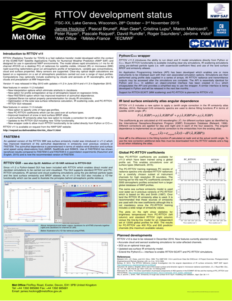
RTTOV development status ITSC-XX, Lake Geneva, Wisconsin, 28th October – 3rd November 2015 James Hocking1, Pascal Brunel2, Alan Geer3, Cristina Lupu3, Marco Matricardi3, Peter Rayer1, Pascale Roquet2, David Rundle1, Roger Saunders1, Jérôme Vidot2 1Met Office 2Météo-France 3ECMWF Introduction to RTTOV v11 RTTOV (Radiative Transfer for TOVS) is a fast radiative transfer model developed within the context of the EUMETSAT Satellite Applications Facility for Numerical Weather Prediction (NWP SAF) and designed for use in operational NWP environments. The model allows rapid simulations (<1 ms for 40 channel ATOVS on a desktop PC) of radiances for satellite visible, infrared (IR) or microwave (MW) nadir-scanning radiometers given an atmospheric profile of temperature, variable gas concentrations, cloud and surface properties. Many sensors are supported. Clear-sky optical depth calculations are based on a regression on a set of atmospheric predictors carried out over a range of input profiles. Computations may optionally include scattering by clouds and aerosols at IR wavelengths, and by clouds and precipitation at MW frequencies. Version 11 was released in May 2013 with updates v11.2 in June 2014 and v11.3 in September 2015. New features in version 11.2 included: • New interpolation options which eliminate artefacts in Jacobians. • New option for profile extrapolation at top of atmosphere based on regression limits. • New FASTEM-6 option which has improved treatment of azimuthal dependence. • Updated Baran ice optical property parameterisation for cloudy IR simulations. • Optimisation of the solar sea surface reflectance calculation, IR scattering code, and PC-RTTOV. • RTTOV GUI released. New features in version 11.3 include: • New option to specify units of input gas profiles. • New PC-RTTOV coefficients which can be used over all surface types. • Improved treatment of snow in land surface BRDF atlas. • Land surface IR emissivity atlas has new option to include a correction for zenith angle. • Updates to the RTTOV GUI including new 1DVar functionality. • New wrapper code to allow much RTTOV functionality to be called directly from Python or C/C++. RTTOV v11 is available on request from the NWP SAF website: http://nwpsaf.eu/deliverables/rtm/rtm_rttov11.html FASTEM-6 An updated version of the RTTOV MW sea surface emissivity model was introduced in v11.2 which has improved treatment of the azimuthal dependence in emissivity over previous versions of FASTEM. The azimuthal dependence is parameterised in terms of relative wind direction and surface wind speed using observations from AMSR, SeaWinds and SSMI/S. Use of FASTEM-6 has shown beneficial results compared to FASTEM-3 and FASTEM-5 in assimilation experiments (Kazumori and English, 2015) and is now the recommended version of FASTEM. RTTOV GUI – see also 2p.02: Addition of 1D-VAR retrieval to RTTOV-GUI Since v11.2 a Python-based GUI has been included with RTTOV which enables direct model and Jacobian simulations to be carried out and visualised. The GUI supports standard RTTOV and PCRTTOV simulations, IR aerosol and cloud scattering simulations using the pre-defined particle types and the land surface emissivity and BRDF atlases. As of v11.3 the GUI also includes a 1D-Var functionality which can be used to illustrate the principles behind atmospheric profile retrieval. Python/C++ wrapper RTTOV v11.3 introduces the ability to run direct and K model simulations directly from Python or C++. Much RTTOV functionality is available including clear-sky simulations, IR scattering simulations using pre-defined particle types (i.e. with scaer/sccld coefficient files) and use of the land surface BRDF and emissivity atlases. An Application Programming Interface (API) has been developed which enables one or more instruments to be initialised each with their own associated simulation options. Simulations are then performed using profile data supplied in a series of arrays. All RTTOV radiance and transmittance outputs may be accessed after the simulations are complete. The API is essentially identical for Python and C++. In addition an object-oriented interface has been created in C++ which encapsulates the API and provides a simplified way to use the wrapper. A similar interface is being developed in Python and will be released in the next few months. Support for RTTOV-SCATT (MW scattering) and PC-RTTOV is planned for RTTOV v12. IR land surface emissivity atlas angular dependence RTTOV v11.3 includes a new option to apply a zenith angle correction in the IR emissivity atlas (Borbas, 2014). Retrieved CrIS emissivity spectra are used to derive fitting functions F in terms of satellite zenith angle ( θ ): F (λ, IGBP) = p1 (λ, IGBP)θ 2 + p2 (λ, IGBP)θ + p3 (λ, IGBP) The coefficients pi are calculated at 416 wavelengths ( λ ) for different surface types as identified by the International Geosphere‐Biosphere Program (IGBP) Ecosystem Database (Belward, 1996). Different corrections are applied for day and night and in each of the four seasons. The angular dependence is implemented as an optional correction to the emissivities from the existing atlas: ε angcorr (λ) = ε original (λ )(1 − dF (λ, IGBP)) Here dF is the difference in the fitting function F calculated at nadir and at the actual zenith angle. To use the new correction additional data files must be downloaded from the RTTOV website and a flag is set when initialising the atlas. Global PC-RTTOV coefficients New PC-RTTOV coefficients are available for v11.3 which have been trained using a global profile set. This enables simulations over all surface types (Matricardi, 2015). The PC-RTTOV training regresses PC scores of radiance spectra onto standard RTTOV radiances for a carefully chosen subset of instrument channels for high resolution IR sounders. The training set for the new PC coefficients consists of 3000 atmospheric profiles extracted from a larger global database of NWP profiles. The same sea surface emissivity model is used over water as in previous versions of PC-RTTOV which is based on Wu and Smith (1997). Over land the RTTOV IR emissivity atlas is used. It is recommended that these sources of emissivity are used with the new coefficients although this is not mandatory since the PC-RTTOV training includes a wide range of emissivity values. Above: temperature and water vapour Jacobians for all ATMS channels together (right) and Jacobians for channel 22 (left). The plots on the right show statistics for brightness temperatures from PC-RTTOV (left column) and standard RTTOV (right column) versus the line-by-line model for an independent set of 12000 global profiles for IASI. The results for PC-RTTOV use 400 PCs and 600 predictor channels (the maximum available values). Below: illustration of a 1D-Var retrieval using ATMS. Planned developments RTTOV v12 is due to be released in December 2016. New features currently planned include: • Accurate cloud and aerosol scattering simulations for solar-affected channels. • SO2 as an optional trace gas. • Updated sea surface IR emissivity model. • Extend the Python/C++ interface to enable RTTOV-SCATT and PC-RTTOV simulations. References Belward, A.S., J.E. Estes, and K.D. Kline, 1999. The IGBP-DIS 1-Km Land-Cover Data Set DISCover: A Project Overview. Photogrammetric Engineering and Remote Sensing, v.65, no. 9, p. 1013-1020. Borbas, E, 2014. The RTTOV UWiremis module Investigation into the angular dependence of IR surface emissivity. NWP SAF report. http://nwpsaf.eu/vs_reports/nwpsaf-mo-vs-050.pdf Kazumori, M. and S.J. English, 2015. Use of the ocean surface wind direction signal in microwave radiance assimilation, Q. J. Royal Met. Soc., vol. 141, No. 689, Part B, pp 1354–1375, doi: 10.1002/qj.2445 Matricardi, M., 2015. The direct assimilation of principal components of IASI spectra in the ECMWF 4D-Var and the training of PC_RTTOV over land surfaces. http://nwpsaf.eu/deliverables/rtm/docs_rttov11/matricardi_2015_pcrttov_global.pdf Wu, X. and W. L. Smith, 1997. Emissivity of rough sea surface for 8-13µm: modelling and validation, Appl. Opt. 36 1-11 Met Office FitzRoy Road, Exeter, Devon, EX1 3PB United Kingdom Tel: +44 1392 885680 Fax: +44 1392 885681 Email: james.hocking@metoffice.gov.uk © Crown copyright | Met Office and the Met Office logo are registered trademarks
