Integrating the Beltline
advertisement
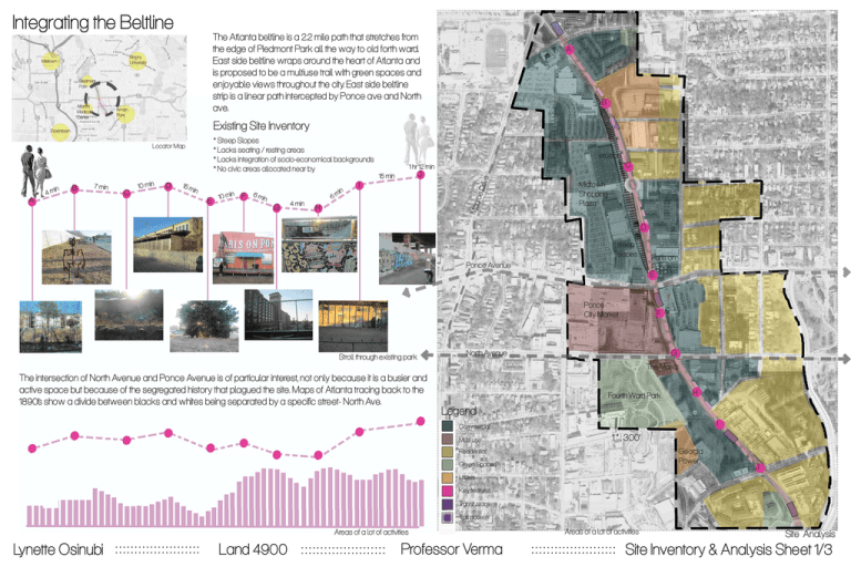
Integrating the Beltline The Atlanta beltline is a 2.2 mile path that stretches from the edge of Piedmont Park all the way to old forth ward. East side beltline wraps around the heart of Atlanta and is proposed to be a multiuse trail with green spaces and enjoyable views throughout the city. East side beltline strip is a linear path intercepted by Ponce ave and North ave. Emory University Midtown Piedmont Park Inman Park Existing Site Inventory * Steep Slopes * Lacks seating / resting areas * Lacks integration of socio-economical backgrounds * No civic areas allocated near by Locator Map C J I D E roe D A C erosion F G rive Downtown B B Mon Atlanta Medical Center A H Midtown Shopping Plaza D steep slopes Ponce Avenue Ponce City Market Stroll through existing park Paris on Ponce E F G North Avenue The Masq. The intersection of North Avenue and Ponce Avenue is of particular interest, not only because it is a busier and active space but because of the segregated history that plagued the site. Maps of Atlanta tracing back to the 1890’s show a divide between blacks and whites being separated by a specific street- North Ave. Fourth Ward Park H Legend I Commercial Multi-use 1 “ : 300’ Georgia Power Residential Green Spaces J Utilities Key features Transit stops Trail access Areas of a lot of activities Lynette Osinubi Land 4900 Professor Verma Areas of a lot of activities Site Analysis Site Inventory & Analysis Sheet 1/3 Integrating the Beltline Ponce De Leon Pl Ponce De Leon Crossing e eltlin nta B Atla The concept of the Beltline design is to combat the lack of social cohesion and promote racial integration, the lack of which has plagued the original site. North Avenue is the dividing line between the rich and po or, and so the area around its intersection with the beltline is of particular interest. By creating pockets of green spaces that are mutually shared with different social groups it will allow for a cohesive neighborho od and diverse experience. By creating more entrances into the beltline from the surrounding areas, it allows for the residents to have a dynamic experience of seeing people on the trail, but still feeling like they have their own sense of community. By creating entrances into the beltline using a 45 degree angle it allows for the beltline to have a distinct entrance identity within the east side trail. Gleenwo od Ave St Charles Ave Beltline trail with lush planting Ponce D e Leon A ve Ponce City Market Forth Ward Middle North Ave Legend 1 “ : 200’ Commercial High end Residential Mixed- Income Green Spaces Civic Transit station Shared community plaza with different socio-economical housing Lynette Osinubi Land 4900 Multi-use Professor Verma Forth Ward Park Beltline Trail Masterplan Masterplan 2/3 Integrating the Beltline Arch Detailed Design The key feature for this detailed design is the arch that symbolizes unity. The arch will act as an Amphitheatre for the entrance to the newly proposed middle scho ol - Fourth Ward Middle. A Rock Garden down Fo od Cart Area B Steel Arch Fourth Ward Middle Open Recreational Space B down Murals A Having a middle scho ol in between Ponce and North Avenue will integrate different children from diverse backgrounds. A A Lynette Osinubi Land 4900 Professor Verma B 1 “ : 20’ B The Scho ol Plaza 3/3
