LETTERS The Borealis basin and the origin of the martian crustal dichotomy
advertisement
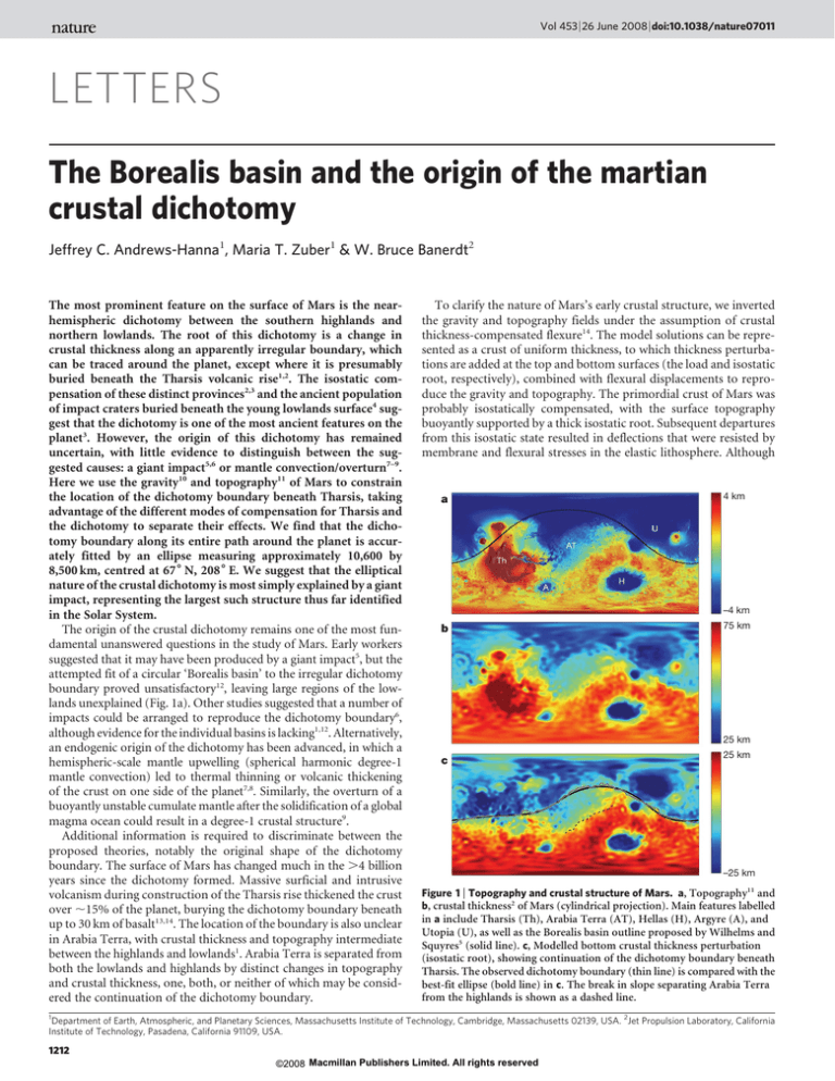
Vol 453 | 26 June 2008 | doi:10.1038/nature07011 LETTERS The Borealis basin and the origin of the martian crustal dichotomy Jeffrey C. Andrews-Hanna1, Maria T. Zuber1 & W. Bruce Banerdt2 The most prominent feature on the surface of Mars is the nearhemispheric dichotomy between the southern highlands and northern lowlands. The root of this dichotomy is a change in crustal thickness along an apparently irregular boundary, which can be traced around the planet, except where it is presumably buried beneath the Tharsis volcanic rise1,2. The isostatic compensation of these distinct provinces2,3 and the ancient population of impact craters buried beneath the young lowlands surface4 suggest that the dichotomy is one of the most ancient features on the planet3. However, the origin of this dichotomy has remained uncertain, with little evidence to distinguish between the suggested causes: a giant impact5,6 or mantle convection/overturn7–9. Here we use the gravity10 and topography11 of Mars to constrain the location of the dichotomy boundary beneath Tharsis, taking advantage of the different modes of compensation for Tharsis and the dichotomy to separate their effects. We find that the dichotomy boundary along its entire path around the planet is accurately fitted by an ellipse measuring approximately 10,600 by 8,500 km, centred at 676 N, 2086 E. We suggest that the elliptical nature of the crustal dichotomy is most simply explained by a giant impact, representing the largest such structure thus far identified in the Solar System. The origin of the crustal dichotomy remains one of the most fundamental unanswered questions in the study of Mars. Early workers suggested that it may have been produced by a giant impact5, but the attempted fit of a circular ‘Borealis basin’ to the irregular dichotomy boundary proved unsatisfactory12, leaving large regions of the lowlands unexplained (Fig. 1a). Other studies suggested that a number of impacts could be arranged to reproduce the dichotomy boundary6, although evidence for the individual basins is lacking1,12. Alternatively, an endogenic origin of the dichotomy has been advanced, in which a hemispheric-scale mantle upwelling (spherical harmonic degree-1 mantle convection) led to thermal thinning or volcanic thickening of the crust on one side of the planet7,8. Similarly, the overturn of a buoyantly unstable cumulate mantle after the solidification of a global magma ocean could result in a degree-1 crustal structure9. Additional information is required to discriminate between the proposed theories, notably the original shape of the dichotomy boundary. The surface of Mars has changed much in the .4 billion years since the dichotomy formed. Massive surficial and intrusive volcanism during construction of the Tharsis rise thickened the crust over ,15% of the planet, burying the dichotomy boundary beneath up to 30 km of basalt13,14. The location of the boundary is also unclear in Arabia Terra, with crustal thickness and topography intermediate between the highlands and lowlands1. Arabia Terra is separated from both the lowlands and highlands by distinct changes in topography and crustal thickness, one, both, or neither of which may be considered the continuation of the dichotomy boundary. To clarify the nature of Mars’s early crustal structure, we inverted the gravity and topography fields under the assumption of crustal thickness-compensated flexure14. The model solutions can be represented as a crust of uniform thickness, to which thickness perturbations are added at the top and bottom surfaces (the load and isostatic root, respectively), combined with flexural displacements to reproduce the gravity and topography. The primordial crust of Mars was probably isostatically compensated, with the surface topography buoyantly supported by a thick isostatic root. Subsequent departures from this isostatic state resulted in deflections that were resisted by membrane and flexural stresses in the elastic lithosphere. Although a 4 km –4 km b 75 km 25 km c 25 km –25 km Figure 1 | Topography and crustal structure of Mars. a, Topography11 and b, crustal thickness2 of Mars (cylindrical projection). Main features labelled in a include Tharsis (Th), Arabia Terra (AT), Hellas (H), Argyre (A), and Utopia (U), as well as the Borealis basin outline proposed by Wilhelms and Squyres5 (solid line). c, Modelled bottom crustal thickness perturbation (isostatic root), showing continuation of the dichotomy boundary beneath Tharsis. The observed dichotomy boundary (thin line) is compared with the best-fit ellipse (bold line) in c. The break in slope separating Arabia Terra from the highlands is shown as a dashed line. 1 Department of Earth, Atmospheric, and Planetary Sciences, Massachusetts Institute of Technology, Cambridge, Massachusetts 02139, USA. 2Jet Propulsion Laboratory, California Institute of Technology, Pasadena, California 91109, USA. 1212 ©2008 Macmillan Publishers Limited. All rights reserved LETTERS NATURE | Vol 453 | 26 June 2008 the observed dichotomy is largely isostatic2,3 and thus dominated by the isostatic roots, the gravity anomalies13 and tectonic features14,15 surrounding Tharsis suggest that the rise is largely a flexurally supported load. Generalizing this thinking, we suggest that the loads and displacements in the Tharsis province should be dominated by Tharsis itself, whereas the isostatic roots should reflect the preTharsis dichotomy, thus enabling us to isolate the dichotomy beneath Tharsis (Supplementary Fig. 1). The continuation of the dichotomy boundary beneath Tharsis is clearly visible in the model isostatic roots (Fig. 1b). The model cannot account for the full complexity of Tharsis loading, such as a spatially and temporally variable lithosphere thickness during Tharsis construction, or crustal and mantle density anomalies. As a result, the roots are negative beneath younger portions of the rise that are probably supported by a thicker lithosphere (for example Olympus Mons), and positive beneath older portions that are largely isostatic today (for example Tempe Terra). Nevertheless, considering both the present-day topography and the isostatic roots, we are able to map the dichotomy boundary both beneath Tharsis and elsewhere (Fig. 1c; see also Methods). The sub-Tharsis dichotomy is continuous to the west with the observed boundary, and to the east with the break in slope north of Arabia Terra. Although the northern edge of Arabia Terra is sharply defined and continuous with the dichotomy boundary on either side, the southern edge is less distinct and not obviously connected with the boundary (Supplementary Fig. 3c). We also note that the magnetic anomalies distributed throughout much of the highlands are also found within Arabia Terra16. Collectively, this evidence suggests that Arabia Terra is a part of the highlands. The cause of its unique topography will be addressed later in this paper. The path of the dichotomy boundary around the entire planet is now well fitted by an ellipse centred on 67u N, 208u E (Fig. 1c). To best display the shape of the boundary, we re-project Mars in polar coordinates around the best-fit centre of the ellipse (Fig. 2). The ellipse has long and short axes of 10,600 and 8,500 km, respectively, with the long axis oriented towards N76uE, and matches the dichotomy boundary with a root-mean-square misfit of 6100 km (excluding the uncertainty in mapping the boundary location). The full extent of the lowlands now covers 42% of the surface. The elliptical nature of the crustal dichotomy provides a new constraint on models of its formation. Giant impacts with low-angle trajectories produce elliptical basins, such as Hellas on Mars (ratio of major to minor axes, a/b 5 2,414 km/1,820 km 5 1.33) and South Pole–Aitken on the Moon (a/b 5 2,125 km/1,542 km 5 1.38). Although the Borealis basin far exceeds these and all other impact basins in size, it is comparable in aspect ratio (a/b 5 1.25). Departures from the elliptical shape can be attributed to local erosion, relaxation and tectonic modification of the boundary17. It is unclear at this point whether endogenic processes can explain the elliptical boundary. Although the upwellings in degree-1 convection models range from irregular to quasi-circular in shape8, there is no known reason to expect a geometric elliptical pattern to emerge. Global crustal thickness histograms provide a further constraint on the nature of the dichotomy, demonstrating a roughly bimodal distribution2 between the lowlands and highlands (Fig. 3a). Exclusion of terrains in which subsequent processes have altered the primordial crustal thickness (known basins, Tharsis and Elysium) enhances this bimodal structure, and removal of the anomalous Arabia Terra as well separates the two modes completely. The excavation of crust in a giant impact is known to produce a bimodal distribution of crustal thickness between the basin floor and its surroundings, as demonstrated by Hellas (Fig. 3b). The present-day lowlands crust would have differentiated from an impact-generated local magma ocean. Although there have been no explicit studies of the effects of degree-1 mantle convection on the crustal thickness distribution, convection models are characterized by a centralized upwelling that expands laterally on reaching the base of the lithosphere7,8. The resulting gradual decrease in the thermal and mechanical effects away from the upwelling7 would suggest a similarly gradual decrease in the volcanic thickening or thermal erosion. This is exemplified by Tharsis, which has also been attributed to degree-1 mantle convection18. A crustal thickness histogram of the southern portion of Tharsis and a nearly equal area of adjacent highlands (Fig. 3c) demonstrates that in this case degree-1 volcanic thickening did not produce a bimodal distribution. An impact origin for the crustal dichotomy suggests that other secondary basin-related features should have formed. However, the superposition of a saturated crater population over the dichotomy has erased all but the large-scale crustal thickness signature. Giant impact basins are commonly surrounded by a multiple ring system, with radii scaled by factors of !2 (,1.41) relative to the basin radius19. It is interesting to note that the southern edge of Arabia Terra roughly parallels the dichotomy boundary at a mean distance from the ellipse centre of ,1.57 times the local ellipse radius, suggesting a possible origin as a modified or partial outer basin ring. The ring structures of the Hellas and Argyre basins on Mars consist of an inwards-facing scarp at the outer ring, transitioning to a concave-upwards to sloping bench of lower topography and thinner crust, before reaching the main basin rim. Comparison of the azimuthally averaged topographic a c e 4 km b 30 km –4 km –20 km 0.005 d 30 km 0 –20 km 80 km f 80 km 30 km 30 km Figure 2 | Projected views of the Borealis basin. Projection in polar coordinates around the basin centre at 67u N, 208u E, showing the presentday topography and shaded relief of Mars (a), the modelled crustal root (b), and the topographic gradient at 4u wavelength (c). The traced dichotomy boundary is shown in d and compared with the best-fit ellipse (southern boundary of Arabia Terra denoted by dashed line). Outlines of the northern and southern edges of Arabia Terra (dotted lines; approximated using a threshold crustal thickness) are shown over a crustal thickness map2 in e, along with the reconstructed basin rim required to restore the crustal thickness in Arabia Terra to the mean highlands value (solid line; see Methods). The reconstructed crustal thickness before basin modification in Arabia Terra is shown in f. Note that this projection preserves radial distance from the centre, and thus accurately represents the shape of the dichotomy boundary while distorting features not centred on the origin. 1213 ©2008 Macmillan Publishers Limited. All rights reserved LETTERS a NATURE | Vol 453 | 26 June 2008 7 Global crustal thickness Thickness minus basins, Tharsis, Elysium Thickness minus Arabia Terra, basins, Tharsis, Elysium Tharsis 6 dA/dz (106 km) 5 4 3 2 1 0 0 20 40 60 Crustal thickness (km) b c 8 80 12 Hellas region dA/dz (105 km) 100 S. Tharsis region 6 8 4 4 2 0 20 40 60 Crustal thickness (km) 80 0 50 60 70 80 90 100 Crustal thickness (km) Figure 3 | Crustal thickness histograms. a, Global crustal thickness histogram (dashed), after removal of the major impact basins and volcanic rises (solid), and after removal of the anomalous Arabia Terra region as well (dotted). The histogram of the Tharsis region (excluding surrounding terrains) is shown in grey. For comparison, histograms are also shown of the Hellas impact basin and surrounding highlands (b), and the southern portion of Tharsis and the surrounding highlands (in order to avoid the competing effects of the superimposed dichotomy boundary beneath Tharsis; c). Histograms are presented as total area A per unit crustal thickness z, calculated in thickness increments of 0.5 km. profile of the Borealis basin through Arabia Terra with profiles of Hellas and Argyre reveals a similarity in structure (Fig. 4). One model for the formation of multi-ring structures involves the inward flow of the ductile lower crust and mantle in the moments following the Elevation (km) a b 3 AT Borealis 4 E. Hellas 0 0 –3 –4 –6 0 4,000 c 8,000 –8 d4 2 Argyre 0 800 1,600 W. Hellas 0 0 METHODS SUMMARY –4 –2 –4 0 400 excavation of the transient cavity, leading to tectonic failure at the outer ring scarp20. A subtle change in the orientation of the dichotomy boundary at the eastern edge of Arabia Terra (Fig. 2c) suggests that this inward flow during ring formation may have displaced the basin rim northwards here. This lower crustal flow can also explain the northward shift of the dichotomy boundary at the Moho relative to the topographic boundary in Arabia Terra1, and the associated gravity signature of the boundary21. This putative multi-ring structure does not fully encircle the basin, but a partial ring is also observed around the Caloris basin on Mercury22. The original basin rim location can be estimated by calculating the shortening required to restore the crust in Arabia Terra to the mean highlands thickness (Fig. 2e, f), leading to a corrected ring spacing of 1.42. One of the primary objections to the giant impact hypothesis is that the prodigious volume of melt produced by such an energetic impact would erase any signature of the basin23. However, recent simulations of oblique dichotomy-forming impacts24 predict a smaller melt volume that is largely contained within the basin. Giant impact basins are thought to reach a near-isostatic state rapidly after the impact owing to the rebound of the basin floor, and the melt volume that can be contained within depends on the melt density (dominated by mantle material23) and the thickness of the surrounding crust. For the arbitrary case of a melt density intermediate between that of the unmelted crust and mantle, a crustal thickness of 70 km outside the basin would allow an isostatic magma pond up to 140 km in depth within the basin, corresponding to a global equivalent depth of 56 km of melt, compatible with the numerically predicted24 global equivalent depth of 6–80 km. This local magma ocean would then differentiate to produce the present lowlands crust. Once formed, the crustal thickness signature of the dichotomy would not be expected to relax significantly25, despite the high heat flow on early Mars26. Models suggest that the deepest basins are slowest to relax, on account of the resistance to flow of the thin basin-floor crust27, explaining the lack of relaxation of Hellas and South Pole–Aitken. By demonstrating that the northern lowlands are in fact elliptical in shape, we have removed the main obstacle to the impact hypothesis for the origin of the dichotomy. Recent numerical modelling work24 has addressed the dynamical challenges to an impact origin. Although the alternative endogenic models remain viable, this work suggests that the giant impact hypothesis best explains the salient properties of the martian dichotomy. If the dichotomy was indeed formed by a giant impact, it would be the largest observed impact scar in the Solar System by a factor of ,4. Such large impacts were probably common during the waning stages of planetary accretion28. The formation of the Earth’s Moon is attributed to a giant impact on the Earth by a Mars-sized body29. Similarly, the high density of Mercury may be the result of a giant impact that stripped the outer portions of its mantle30. These impacts were so catastrophic as to remove any trace of a basin from the surface. Although the details of giant impact basin formation and modification are poorly understood, it stands to reason that a basin might exist that spans the gap between the unambiguous Hellas and South Pole–Aitken basins, and the self-erasing Moon-forming and Mercury-stripping impacts. –8 800 0 Radial distance (km) 800 1,600 Figure 4 | Radial profiles of the Borealis (through Arabia Terra), Hellas and Argyre basins. Average profiles (black) and the 1s variation (grey) were calculated from radial profiles at 1u increments. Borealis and Hellas were stretched in a basin-centred polar coordinate system to circularize the basins before averaging. Profiles of Hellas and Argyre avoided regions with obvious evidence of fluvial, volcanic, or subsequent impact modification (see Supplementary Fig. 6 for locations of profiles). The arrows indicate the approximate locations of the basin rim and outer ring. The gravity and topography of Mars were inverted using a spherical harmonic thin-shell model14. The gravity field10 was expanded out to degree and order 60, with a cosine taper between degrees 55 and 60. The model assumes values of the mean crustal thickness (50 km), lithosphere thickness (50–200 km), crustal density (2,900 kg m23) and mantle density (3,500 kg m23) consistent with estimates for Mars, and values of Young’s modulus (100 GPa) and Poisson’s ratio (0.25) consistent with typical terrestrial values. The modelled bottom crustal thickness perturbations are assumed to be representative of the ancient isostatic crustal roots and thus to reflect the original crustal dichotomy before Tharsis loading. We then found the best-fit ellipse to the globally continuous dichotomy boundary by iterating the ellipse dimensions, centre coordinates, and orientation to minimize the root-mean-square misfit with the mapped boundary. 1214 ©2008 Macmillan Publishers Limited. All rights reserved LETTERS NATURE | Vol 453 | 26 June 2008 Full Methods and any associated references are available in the online version of the paper at www.nature.com/nature. Received 20 December 2007; accepted 4 April 2008. 1. 2. 3. 4. 5. 6. 7. 8. 9. 10. 11. 12. 13. 14. 15. 16. Zuber, M. T. et al. Internal structure and early thermal evolution of Mars from Mars Global Surveyor topography and gravity. Science 287, 1788–1793 (2000). Neumann, G. A., Lemoine, F. G., Smith, D. E. & Zuber, M. T. Marscrust3: A crustal thickness inversion from recent MRO gravity solutions. Lunar Planet. Sci. Conf. 39, abstr. 2167 (2008). Solomon, S. C. et al. New perspectives on ancient Mars. Science 307, 1214–1220 (2005). Frey, H. V., Roark, J. H., Shockey, K. M., Frey, E. L. & Sakimoto, S. E. H. Ancient lowlands on Mars. Geophys. Res. Lett. 29, doi:10.1029/2001GL013832 (2002). Wilhelms, D. E. & Squyres, S. W. The martian hemispheric dichotomy may be due to a giant impact. Nature 309, 138–140 (1984). Frey, H. & Shultz, R. A. Large impact basins and the mega-impact origin for the crustal dichotomy on Mars. Geophys. Res. Lett. 15, 229–232 (1988). Zhong, S. & Zuber, M. T. Degree-1 mantle convection and the crustal dichotomy on Mars. Earth Planet. Sci. Lett. 189, 75–84 (2001). Roberts, J. H. & Zhong, S. Degree-1 convection in the martian mantle and the origin of the hemispheric dichotomy. J. Geophys. Res. 111, E06013, doi:10.1029/ 2005JE002668 (2006). Elkins-Tanton, L. T., Hess, P. C. & Parmentier, E. M. Possible formation of ancient crust on Mars through magma ocean processes. J. Geophys. Res. 110, E12S01, doi:10.1029/2005JE002480 (2005). Konopliv, A. S. et al. MROMGM23C gravity model. NASA Planet. Data Sys. Æhttp:// pds.jpl.nasa.govæ (submitted). Smith, D. E. et al. Mars Orbiter Laser Altimeter: Experiment summary after the first year of global mapping of Mars. J. Geophys. Res. 106 (E10), 23689–23722 (2001). McGill, G. E. & Squyres, S. W. Origin of the martian crustal dichotomy: Evaluating hypotheses. Icarus 93, 386–393 (1991). Phillips, R. J. et al. Ancient geodynamics and global-scale hydrology on Mars. Science 291, 2587–2591 (2001). Banerdt, W. B. & Golombek, M. P. Tectonics of the Tharsis region of Mars: Insights from MGS topography and gravity. Lunar Planet. Sci. Conf. 31, abstr. 2038 (2000). Andrews-Hanna, J. C., Zuber, M. T. & Hauck, S. A. Strike-slip faults on Mars: Observations and implications for global tectonics and geodynamics. J. Geophys. Res. doi:10.1029/2008JE002980 (in the press). Arkami-Hamed, J. A coherent model of the crustal magnetic field of Mars. J. Geophys. Res. 109, E09005, doi:10.1029/2004JE002265 (2004). 17. Smrekar, S. E., McGill, G. E., Raymond, A. & Dimitriou, A. M. Geologic evolution of the martian dichotomy in the Ismenius area of Mars and implications for plains magnetization. J. Geophys. Res. 109, E11002, doi:10.1029/2004JE002260 (2004). 18. Harder, H. & Christensen, U. A one-plume model of martian mantle convection. Nature 380, 507–509 (1996). 19. Melosh, H. J. Impact Cratering: A Geologic Process (Oxford Univ. Press, New York, 1989). 20. Melosh, H. J. & McKinnon, W. B. The mechanics of ringed basin formation. Geophys. Res. Lett. 5, 985–988 (1978). 21. Kiefer, W. S. Gravity, topography, and tectonic segmentation of the martian hemispheric dichotomy: Evidence for multiple formation mechanisms. Lunar Planet. Sci. Conf. 38, abstr. 1470 (2007). 22. Strom, R. et al. Tectonism and volcanism on Mercury. J. Geophys. Res. 80, 2478–2507 (1975). 23. Tonks, W. B. & Melosh, H. J. Magma ocean formation due to giant impacts. J. Geophys. Res. 98, 5319–5333 (1993). 24. Marinova, M. M., Aharonson, O. & Asphaug, E. Mega-impact formation of the Mars hemispheric dichotomy. Nature doi:10.1038/nature07070 (this issue). 25. Nimmo, F. & Stevenson, D. J. Estimates of martian crustal thickness from viscous relaxation of topography. J. Geophys. Res. 106, 5085–5098 (2001). 26. Parmentier, E. M. & Zuber, M. T. Early evolution of Mars with mantle compositional stratification or hydrothermal crustal cooling. J. Geophys. Res. 112, E02007, doi:10.1029/2005JE002626 (2007). 27. Mohit, P. S. & Phillips, R. J. Viscous relaxation on early Mars: A study of ancient impact basins. Geophys. Res. Lett. 34, L21204, doi:10:1029/2007GL031252 (2007). 28. Wetherill, G. W. Occurrence of giant impacts during the growth of the terrestrial planets. Science 228, 877–879 (1985). 29. Canup, R. M. & Esposito, L. W. Accretion of the Moon from an impact-generated disk. Icarus 119, 427–446 (1996). 30. Wetherill, G. W. in Mercury (eds Vilas, F., Chapman, C. R. & Mathews, M. S.) 670–691 (Univ. Arizona Press, Tucson, 1988). Supplementary Information is linked to the online version of the paper at www.nature.com/nature. Acknowledgements We thank J. Melosh for a review. This work was supported by grants to M.T.Z. from the Mars Reconnaissance Orbiter project, operated under the auspices of the NASA Mars Program. Author Information Reprints and permissions information is available at www.nature.com/reprints. Correspondence and requests for materials should be addressed to J.C.A.-H. (jhanna@mit.edu). 1215 ©2008 Macmillan Publishers Limited. All rights reserved doi:10.1038/nature07011 METHODS Gravity–topography inversion. The observed martian gravity and topography were inverted under the assumption of crustal thickness-compensated flexure, using the model of Banerdt31 (see refs 14 and 31 for full details). By taking into account the strength of the lithosphere, the model solves for the crustal thickness and subdivides the crust into that portion which is supported by the membrane and flexural stresses in the lithosphere and that which is in isostatic balance. The model results are represented as a crust of uniform thickness, to which thickness perturbations are added at the top and bottom boundaries (the loads and isostatic roots, respectively) that, together with the resulting displacements, reproduce the observed gravity and topography. Note that the ‘isostatic root’ as defined here removes the flexural contribution from the conventional crustal root, defined as that portion of the crust below a particular equipotential. The pre-Tharsis crustal dichotomy was probably isostatically compensated, with a buoyant crustal root supporting the topography of the highlands, resulting in zero flexure. In contrast, Tharsis would have been largely a flexurally supported load (Supplementary Fig. 1). The primary uncertainty is the choice of lithosphere thickness. Although admittance studies of the lithosphere thickness supporting shorter-wavelength loads suggest a thin lithosphere (,50 km) during the Noachian32,33, models of Tharsis loading suggest that a lithosphere thickness of ,100 km is required to reproduce the observed gravity anomalies13 and explain the tectonic history of the rise14,15. As a possible explanation for this discrepancy, we suggest that early Mars may have had an upper crustal lithosphere separated from a mantle lithosphere by a ductile lower crust34,35. Short-wavelength, low-amplitude deformation beneath smaller scale loads may be supported entirely by the stresses within the elastic upper crust, with the flexure easily accommodated by the thin, ductile lower crust. In contrast, the long-wavelength, large-amplitude Tharsis deformation may involve support from both the mantle and crustal lithosphere. We consider lithosphere thickness between 50 and 200 km. The isostatic roots beneath Tharsis are largely negative for the 50-km lithosphere (Supplementary Fig. 2a), thus predicting a topographic depression in the Tharsis region before loading. The fact that these negative crustal roots mirror the present-day topography of Tharsis suggests that this is an artefact of assuming an overly thin lithosphere, rather than representing the pre-Tharsis crustal structure. For lithosphere thicknesses ranging between 100 and 200 km, the pre-Tharsis dichotomy boundary is clearly expressed and lies in roughly the same location (Supplementary Fig. 2b–d). Because the latitude of the sub-Tharsis dichotomy varies little across the rise, we also consider longitudinally averaged profiles of the isostatic root through the Tharsis region (Supplementary Fig. 3). The maximum slope delineating the dichotomy boundary scarp occurs in the same location for all lithosphere thicknesses, demonstrating that the inferred location of the subTharsis dichotomy boundary is generally insensitive to this choice. Boundary mapping and ellipse fit. We mapped the dichotomy boundary in a cylindrical projection. The location of the dichotomy boundary was traced outside of Tharsis using the topography and topographic gradient, and beneath Tharsis using the isostatic root and its gradient (Supplementary Fig. 4). The gradient of the root shows the dichotomy boundary clearly continuing from the region west of Tharsis across the rise. Interestingly, the boundary scarp is more distinct beneath the western portion of Tharsis than in Arabia Terra. The dichotomy boundary north of Arabia Terra as seen in the crustal root is less distinct and seems to lie somewhat further north than indicated by the topography1. This could be a result of lower crustal flow during the suggested formation of Arabia Terra as a basin ring structure during the impact, owing to imperfect coupling between the lower ductile and upper brittle crust. Alternatively, it could result from relaxation of the crustal root later in Mars history, or from weathering and retreat of the topographic dichotomy boundary. We trace the more distinct topographic dichotomy boundary in this region. The uncertainties in the boundary location are comparable to the 350-km resolution of the gravity data beneath Tharsis, and less than 100 km outside Tharsis. After global mapping of the dichotomy boundary, we found the best-fit ellipse by iteratively adjusting the location of the ellipse centre, major and minor axes, and orientation of the major axis to minimize the root-mean-square misfit (Supplementary Fig. 5). Tracing the boundary north of Arabia Terra using the isostatic root rather than topography results in a best-fitting ellipse with major and minor axes of 10,600 and 8,100 km, respectively. Alternatively, the reconstructed rim in Arabia Terra leads to ellipse axes of 10,900 and 8,800 km. Basin profile measurement. In comparing the radial profiles of the Borealis basin with profiles of Argyre and Hellas, it was necessary to circularize the basins in the basin-centred coordinate system. We then took azimuthally averaged profiles across the dichotomy in the Arabia Terra region (Supplementary Fig. 6). The rim of Hellas has been modified in places by fluvial and volcanic processes, so profiles were averaged in two sectors of the rim that seem to have been largely preserved. The rim of Argyre is superimposed by one prominent impact crater, and this was similarly excluded from the profiles. Arabia Terra rim reconstruction. We calculated the reconstructed basin rim location in Arabia Terra by assuming that the crustal thickness in Arabia Terra was originally equal to that in the southern highlands, before modification during basin ring formation. Upper and lower crustal thickness thresholds were defined to bracket Arabia Terra (40 and 60 km, respectively). The crustal thickness within Arabia Terra was then integrated in wedges radiating out from the basin centre, and the shortening required to increase the crustal thickness to the mean highlands value was calculated. 31. Banerdt, W. B. Support of long-wavelength loads on Venus and implications for internal structure. J. Geophys. Res. 91, 403–419 (1986). 32. McGovern, P. J. et al. Localized gravity/topography admittance and correlation spectra on Mars: implications for regional and global evolution. J. Geophys. Res. 107, 5136, doi:10.1029/2002JE001854 (2002). 33. McGovern, P. J. et al. Correction to ‘‘Localized gravity/topography admittances and correlation spectra on Mars: Implications for regional and global evolution’’. J. Geophys. Res. 109, doi:10.1029/2004JE002286 (2004). 34. Grott, M. & Breuer, D. The evolution of the martian elastic lithosphere and implications for crustal and mantle rheology. Icarus 193, 503–515 (2008). 35. Montessi, L. G. J. & Zuber, M. T. Clues to the lithospheric structure of Mars from wrinkle ridge sets and localization instability. J. Geophys. Res. 108, 5048, doi:10.1029/2002JE001974 (2003). ©2008 Macmillan Publishers Limited. All rights reserved
