Late-Holocene Moisture and Fire History in the Park Range, Northern...
advertisement

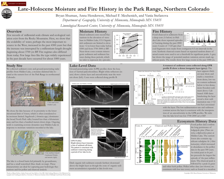
UNIVERSITY OF MINNESOTA Late-Holocene Moisture and Fire History in the Park Range, Northern Colorado Bryan Shuman, Anna Henderson, Michael F. Mechenich, and Vania Stefanova Department of Geography, University of Minnesota, Minneapolis MN 55455 Limnological Research Center, University of Minnesota, Minneapolis MN 55455 Dated sediment cores record fluctuations in the elevation of wave base in Hidden Lake, CO. Organicrich sediments are limited to elevations >2 m lower than today before 4300 and from 3700-3000 yr BP. Near-shore cores contain minerogenic sediment and sediment hiatuses during these periods, which we infer to represent dry episodes. Few records of millennial-scale climate and ecological variation exist from the Rocky Mountains. Here, we show that the avalability of water, perhaps the most important resource in the West, increased in the past 4300 years but that the increase was interupted by a millennium-length drought beginning about 3700 yrs BP. Fire regimes also differed from today. Few large fires like the type widely experienced in the past decade have occurred for about 1000 years. We collected sediment cores and ground-penetrating radar profiles from Hidden Lake, a moraine-dammed lake located at the eastern foot of the Park Range in northcentral Colorado. 400 Wa ase b e v 500 Core C H 600 Core A Zone of Organic Sediment Accumulation 700 30% LOI 5% LOI H Hiatus 800 5000 4000 3000 2000 1000 Cal yr BP Lake-Level Data Ground-penetrating radar (GPR) profiles show the location of burried paleoshorelines. Bright white reflectors (insets) show a dense layer and unconformity near the western shore (left). Cores were collected along profile B. Hidden HiddenLake, Lake,near nearWaldon, Walden,Colorado Colorado A. (File 020) 0 1072 1 0 Depths based on 0.33 m/ns in water. Paleoshoreline 40 80 120 8.5 m 0m ~200 m B. (022) Water 20 5.25 m B. 022 0.6 m 0.3 m C. 024 0.4 m 0.85 m 0 10 20 0 20 40 60 0 C. (024) 0 250 500 1,000 Meters The lake is a closed basin fed primarily by groundwater, and has a small watershed (blue shade on map). These characteristics are ideal for capturing past hydrologic fluctuations and for pollen and charcoal analysis. 1.85 m Scales same for all profiles Dark organic rich sediment extends furthest shoreward above the bright layer as though the zone of organic sediment accumulation expanded as lake levels rose. 20 Depth (cm) 5.75 m 600 Thanks to Djuna Guliver; Anders Noren and Amy Myrbo of the LRC; Mark Linberg, Director of the Minnesota Cartography Lab. Funding provided by a University of Minnesota Graduate School McKnight Land-Grant Professorship. 0 0 two-way travel time (ns) View southwest toward Continental Dividen and moraine (right). 1.1 1.2 1.3 1.4 1.1 1.2 1.3 1.4 1.5 1 1.1 1.2 1.3 1.4 60 70 80 90 100 60 70 80 90 100 Fossil pollen data confirm Charcoal and Pollen Data the long persistence of lodgepole pine (Pinus contorta; a diploxylon pine) at Hidden Lake. The current 20 40 0 5 0 5 0 10 0 10 20 0 10 0 5 0 5 0 20 40 60 forest also contains significant subalpine fir (Abies lasiocarpa), which increased Post-Fire Meadow Fuel Build-Up in abundance in the pollen data in the past 500 years. 930 An initial peak in fir pollen preceeds the largest fire episode of the past millennium. The charcoal peak is 2130 cal yr BP followed by a peak in grass and other herb pollen. Pollen influx data (not shown) are consistent with low tree cover, such as found in a meadow. C ha r (> coa 12 l c 5 on m ce ic n To ro tr ta n at lP pi io ec n in e es (P /c in m3 us ) ) D ip lo xy lo n Pi ne H ap l Fi oxy r ( lo Sp Abi n P ru es ine ce ) (P Sa ge icea br ) us h (A rte G m oo is se ia ) fo ot As (C te he G rs ra (A no ss st po (P era Is da oe o c ce a ea te c ae e e s ae ) ) ) Core A GPR Profiles Bright (dense) layer truncates a lens of sediment off-shore. The pattern is consistent with sediment winnowing during a period of low lake levels. 1 Ecosystem History Data 1.75 m Sed thickness based on 0.028 m/ns estimated from hyperbolas. Velocities estimates range from 0.023 to 0.032 (near shore). 1.1 1.2 1.3 1.4 60 70 80 90 >1.45 m A. 0 1 60 70 80 90 100 Wate r Till We chose the lake because of its proximity to the lower elevational limit of forest, which is often considered to be moisture limited. Sagebrush (Artemisia spp.) dominates the broad North Park valley located less than a kilometere away and less than a hundred meters down slope. Ongoing work is examining ecotone dynamics near Hidden Lake in response to moisture variations recorded at the lake. 1.1 1.2 1.3 60 70 80 90 100 0.85 m Photo from here A transect of sediment cores collected along GPR profile B show a dense inorganic layer (grey). The layer appears thickHidden Lake Lake Selected Selected Cores: Cores: Deep Deep to toShallow Shallow C D E F A est near shore and Deep Cores Bulk Density (g/cm ) marks a transition I J A from dense, low water content sediment 2026 2020 below to less dense, 930 930 3718 3715 1072 1070 2953 2950 more floculent sedi4231 4230 3747 3750 ment above. Cali4370 4395 brated AMS dates 2132 2130 1015 1014 bracketting the layer Location of calibrated AMS radiocarbon ages (median age shown) Macrofossil ages in italics; other AMS ages on bulk sediment Density Core A is to the east (right on GPR profile); core F is to the west (left on GPR). reveal a slow sediWater depth changes 0.5 m between cores. Core F was from 3.5 m of water. mentation rate (<12 Core I was collected at the deepest point of Profile A; Core J from the deepest 2915 Water Content point on Profile C. (Percent wet weight) cm/kyr) associated with the layer. The low sedimentation rate and sediment contrast across the layer is consistent with the interpretation of an unconformity in the GPR profiles. We infer that the lake level was low 3700-2000 cal yr B.P. 2 3.6 m View south across Hidden Lake. 0.8 Fossil charcoal in sediments from 0.6 a deep core (A below) in Hid0.4 0.2 den Lake show repeated episodes 0 of burning during the past 2000 2000 1500 1000 500 0 Cal yr BP years. Counts of >125 mm charcoal fragments were made from contiguous 0.5 cm intervals in the core. Synthetic charcoal counts based on repeated random draws of actual counts were used to set a threshold for significant peaks. A grey bar shows the range of potential random variation; arrows mark significant peaks. The results show few large events in the past 1000 yrs. Core E H Depth (cm) Study Site Zone of Sediment Winnowing Fire History Charcoal Influx (pieces/cm2/yr) Moisture History Depth Below Modern Lake Surface (cm) Overview 40 60 80 100 Copyright, 2006. Bryan Shuman, University of Minnesota. Significant Charcoal Peaks Range of Values Attributa to Random Chance


