GEOPHYSICAL RESEARCH LETTERS, VOL. 16, NO. 12, PAGES
advertisement
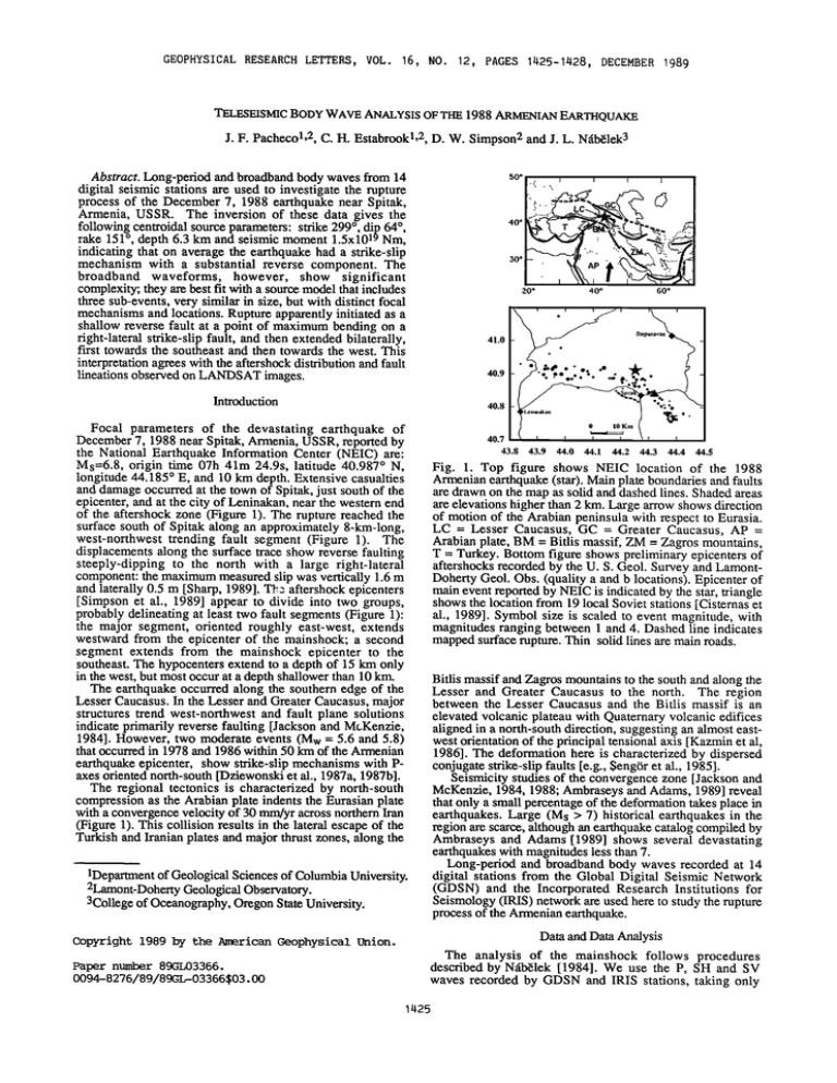
GEOPHYSICAL RESEARCH LETTERS, VOL. 16, NO. 12, PAGES 1425-1428, DECEMBER 1989 TELESEISMIC BODYWAVEANALYSIS OFTHE1988ARMENIAN EARTHQUAKE J.F. Pachecol, 2, C. H. Estabrookl, 2,D. W. Simpson 2 andJ.L. N•b•lek3 Abstract.Long-periodandbroadband bodywavesfrom 14 digital seismicstationsare usedto investigatethe rupture processof the December7, 1988 earthquakenear Spitak, Armenia,USSR. The inversionof thesedata gives the followingcentroidal source parameters: strike299ø,dip64ø, rake 151ø, depth6.3 km and seismicmoment1.5x1019Nm, indicatingthaton averagethe earthquake had a strike-slip mechanismwith a substantialreverse component.The broadband waveforms, however, show significant 50 ø i'........." .--.GC .,!-•,".<• -, 30 ø complexity;they are bestfit with a sourcemodelthatincludes threesub-events,very similarin size, but with distinctfocal mechanisms andlocations.Ruptureapparentlyinitiatedasa shallowreversefault at a point of maximumbendingon a right-lateralstrike-slipfault, andthenextendedbilaterally, ' 40 ø 20 ø 60 ø 40 ø 41.0 first towards the southeast and then towards the west. This interpretationagreeswith the aftershockdistributionandfault lineations observed onLANDSAT images. Introduction 40.9 40.8 Focal parametersof the devastatingearthquakeof December 7, 1988nearSpitak,Armenia,USSR,reported by the National EarthquakeInformationCenter (NEIC) are: 40.7 43.8 43.9 44.0 44.1 44.2 44.3 44.4 44.5 Ms=6.8, origin time 07h 41m 24.9s, latitude 40.987ø N, longitude44.185ø E, and 10 km depth.Extensivecasualties anddamageoccurredat thetownof Spitak,just southof the epicenter,and at the city of Leninakan,nearthe westernend of the aftershock zone(Figure1). The rupturereachedthe Fig. 1. Top figure shows NEIC location of the 1988 surfacesouthof Spitakalongan approximately 8-km-long, west-northwest trendingfault segment(Figure 1). The displacements alongthesurfacetraceshowreversefaulting steeply-dippingto the north with a large right-lateral component: themaximummeasured slipwasvertically1.6m .andlaterally0.5 m [Sharp,1989].TP-:aftershock epicenters [Simpsonet al., 1989] appearto divide into two groups, probablydelineatingat leasttwo fault segments (Figure1): the major segment,orientedroughly east-west,extends LC = Lesser Caucasus,GC = Greater Caucasus,AP = westwardfrom the epicenterof the mainshock;a second segment extends from the mainshock epicenter to the southeast.The hypocentersextendto a depthof 15 km only in thewest,but mostoccurat a depthshallowerthan 10 km. The earthquakeoccurredalong the southernedge of the LesserCaucasus.In the Lesserand GreaterCaucasus,major structurestrend west-northwestand fault plane solutions indicateprimarily reversefaulting [Jacksonand McKenzie, 1984]. However, two moderate events (Mw = 5.6 and 5.8) that occurred in 1978 and 1986 within 50 km of the Armenian Armenianearthquake (star).Main plateboundaries andfaults aredrawnon themap assolidanddashedlines.Shadedareas areelevations higherthan2 km. Largearrowshowsdirection of motionof the Arabianpeninsula with respectto Eurasia. Arabianplate,BM = Bitlismassif,ZM = Zagrosmountains, T = Turkey.Bottomfigureshowspreliminary epicenters of aftershocks recorded by theU.S. Geol.SurveyandLamontDohertyGeol.Obs.(qualitya andb locations). Epicenter of maineventreported byNEIC is indicated bythestar,triangle showsthelocationfrom 19 localSovietstations[Cisternas et al., 1989].Symbolsizeis scaledto eventmagnitude, with magnitudesrangingbetween1 and 4. Dashedline indicates mappedsurfacerupture.Thin solidlinesaremainroads. Bitlis massifandZagrosmountainsto the southandalongthe Lesser and Greater Caucasusto the north. The region between the Lesser Caucasus and the Bitlis massif is an elevatedvolcanicplateauwith Quaternaryvolcanicedifices alignedin a north-southdirection,suggesting an almosteastwestorientationof theprincipaltensionalaxis [Kazminet al, 1986].The deformation hereis characterized by dispersed earthquakeepicenter, show strike-slipmechanismswith Paxesorientednorth-south[Dziewonski et al., 1987a, 1987b]. The regional tectonicsis characterizedby north-south compression as the Arabianplateindentsthe Eurasianplate with a convergence velocityof 30 mm/yr acrossnorthernIran (Figure 1). This collisionresultsin the lateralescapeof the TurkishandIranianplatesandmajorthrustzones,alongthe conjugatestrike-slipfaults[e.g.,$eng0ret al., 1985]. Seismicitystudiesof the convergence zone[Jacksonand McKenzie, 1984, 1988;AmbraseysandAdams,1989]reveal thatonlya smallpercentage of thedeformation takesplacein earthquakes. Large (Ms > 7) historicalearthquakes in the regionarescarce, although anearthquake catalogcompiledby Ambraseysand Adams[1989] showsseveraldevastating earthquakes with magnitudes lessthan7. Long-periodand broadbandbody wavesrecordedat 14 1Deparm•ent ofGeological Sciences of Columbia University. digital stationsfrom the Global Digital SeismicNetwork (GDSN) and the IncorporatedResearchInstitutions for 2Lamont-Doherty Geological Observatory. Seismology (IRIS) networkareusedhereto studytherupture 3College ofOceanography, Oregon State University. process of theArmenianearthquake. Data andData Analysis Copyright 1989 by the American Geophysical Union. The analysis of the mainshockfollows procedures Paper number 89GL03366. 0094-8276/89/89GL-03366 describedby Ngb61ek [1984]. We use the P, SH and SV $03 . 00 wavesrecordedby GDSN and IRIS stations,takingonly 1425 1426 Pachecoet al.: Teleseismic Analysisof the ArmenianEarthquake COL 5' TABLE1.Crustal Structure UsedinComputing Theoretical Seismograms Thickness Vp Vs Density km/s km/s g/cm3 8.10 4.68 3.30 Receiver half-space 6.00 3.46 2.75 Source km 1 5 30 4.00 5.60 6.50 half-space 2.14 3.23 3.75 TOL 285' SLR 196' CHTO 98' 2.35 2.70 2.85 stationsin a distancerange between30ø and 83ø from the epicenterto avoid strong,regionallyvariable,uppermantle arrivalsand corephases.The crustalstructure(Table 1) we assumedin computingtheoreticalseismograms is similarto thatusedby Simpsonet al. [1989] to locatethe aftershocks. The seismograms areinvertedin a least-squares sensefor the source model parameters. For long-period data and intermediatemagnitudeearthquakessuchas the Armenian earthquake, a singlepointsourcemodelusuallyprovidesan adequate sourcedescription.In thatcase,theinversionyields theaverage(centroidal)parameters includingthefaultplane solution(strike, dip, and rake of the slip direction), depth, seismicmoment and time function. If requiredby the data, additionalpoint sourcesseparatedin spaceand time can be introduced,revealingmore detail aboutthe ruptureprocess. In this study,we startedwith the long-periodseismograms to determinethe averagepropertiesof the source,and then refinedthe modelusingthe broadbandrecords. Inversion Results sec Fig. 2. Observed(solid) and theoretical(dashed)broadband seismogramsfor different source models from several azimuthallydistributedstations.Shownare seismograms for Alaska (COL); Spain (TOL); Thailand (CHTO); and South Africa (SLR). The numbernext to stationname is its azimuth from the source. 1S shows the effect of first subevent(see Table 2 for source parameters); 2S shows effects of subevents1 and 2; 3S shows combined effect of 3 subevents (our final model); and BB-PS for broadbandpoint source model. individualpoint sourcesinto our model,eachhavingits own mechanism,time functionanddepth. The two pointsources thatdescribethe laterpart of the ruptureare allowedto have arbitrarytime delay and locationwith respectto the first. In the subsequentdiscussion,we will refer to the three point sourcesas subevents,althoughtheir contributionsin mostof thewaveformsoverlapconsiderably. The parametersof the three subeventsare summarizedin Table 2 andthe matchesto the completedatasetareshownin Figure 3. The initial eventexhibitsprimarilyreversemotion with a small right-lateral strike-slip component. Its mechanismis in good agreementwith the mappedsurface rupture.The nodal plane correspondingto the fault plane, based on field observations,strikes 299ø and dips 45 ø northward.The meandepthof this part of the ruptureis 3.1 The results of a series of inversions we performed are summarizedin Table 2. The long-periodmodel (modelLPPS) indicatesthat,on average,theArmenianearthquake hada strike-slip mechanism with a large reverse-faulting component.The mean (centroid)depth is about 6 km, the seismicmomentis 1.4x10¹⁹Nm, and the sourcedurationis about18 s. When we invert the broadbanddatausinga single point source,we obtain essentiallyidenticalresults(model BB-PS), however, the model does not provide adequate matchto thedata(Figure2), indicatingthatthe sourceprocess wasmore complicated.The main featuresof the datathat the singlepointsourcemodelcannotadequately reproducearethe amplitudes in the early portion of the waveforms (e.g., compareBB-PS and 3S for COL in Figure 2) and the large amplitudearrival about10 s after the first motion(e.g., SLR andCHTO). We haveattemptedto explainthe complexityof azimuth of 153ø relative to the first subevent(nucleation point). This subeventruptureda nearly pure right-lateral strike-slipfault striking 309ø and dipping 90ø, using the aftershockdistribution(Figure 1) as a guidein choosingthe faultplane.The meandepthis 7.2 km andthe sourceduration is 9 s. The third subeventhasa strike-slipmechanismwith a substantialreversecomponentand is located38 km west of the broadband waveforms thenucleation point.The seismicmomentis 5.1x10•8 Nm in terms of the effects of crustal structure(Moho, low velocity layers),but sucheffectsfail to havecorrectpolarities,sufficientamplitudesandtherequired arrivaltimesto fit thedata simultaneously at all the stations. To explain thesefeatures,we were forced to subdividethe ruptureinto three phases.We do this by introducingthree km andthe seismicmomentis 5.9x10¹⁸Nm. The rupture builds up gradually and lasts for almost 9 s. The second subevent with a moment of 7.5x10 •8 Nm locates 17 km at an andthe centroiddepthis 7.3 km. Using a moment tensor summation, the combined mechanismof the three subevents(BB-SUM, Table 2) is a puredoublecouple,in goodagreement with thatobtainedby invertingthe data with a singlepoint source(BB-PS, Table TABLE2. Parameters of theSource ModelsDerivedby theInversion of BodyWaves Moment 1018Nm LP-PS BB-PS BB-SUM 1st subevent 2nd subevent 3rd subevent Depth km Strike deg Dip deg Rake deg Duration Delay s s Distance Azimuth km deg 14.4 14.8 6.3* 6.3 307 299 60 64 159 151 18 17 - - - 14.1 5.9 7.5 5.1 6.0 3.1 7.2 7.3 293 299 309 264 67 45 90 69 141 127 150 148 18 9 9 8 3.8 9.3 17 38 153 277 The formaluncertainties (2(•) are: depth0.4 km, orientation4ø, duration0.5 s, delay0.5 s, distance4 km, azimuth5ø, and moment10%. LP-PS = Long-periodpointsource,BB-PS= Broadband pointsource,BB-SUM = bestdoublecouplefrom sumof subeventmomenttensors,"*" = depthfixed.Distanceandazimuthof thecentroidsof thesecondandthirdsubevents aremeasured with respectto thenucleationpoint(epicenter)of the firstsubevent. Pacheco et al.' Teleseismic Analysis of the Armenian Earthquake P waves ..-. ' SC•--""--•4•'; •:•T" WMQB 2.65 • .... 0 10 20 0 sec 1S 0,001 0 • SeC • SeC SH waves c SCP • BJI wa 0 . . • •.88] o.oo,[• 10 20 sec the surfacerupturesouthof Spitakrepresents only aboutone third of the momentreleasedduringthe earthquake,the rest occurredon faultsat depth[seealsoCisternaset al., 1989; Stein and Yeats, 1989]. The predominantlystrike-slipmechanisms of the Armenian earthquakeand the pfior smaller earthquakesin the region indicatethat the strike-slipmode of deformationin eastern TurkeyandwesternIran extendsat leastpartlyinto theLesser Caucasusas the matefial is squeezedlaterally from the vise formedby the north-southcollisionof Arabia with Eurasia. To explain the broadbanddata, we subdividedthe model into three subeventscorrespondingto three stagesof the rupture process. The mechanism of the first subevent indicates thattheruptureinitiatedon a reversefault.The fault strikeandthe senseof slipfor the first subeventareconsistent with the surfacebreakmappedsouthof Spitak.The shallower depth of this subeventwith respectto the other two, and perhapsalsothe differencein mechanism,may explainwhy onlythispartof therupturereachedthe surface.The seismic momentestimatedfrom the field measurements (thevertical slipof 1.6m; lateralslipof 0.5 m; faultlengthof 8 km; and widthof 8.8 km, basedon the seismologically determined fault dip and centroiddepthof 3.1 km) is 3.5x10¹⁸Nm, ..,• • 8.• o.•] •"... 1427 0 20 • sec SV waves which is somewhat smaller than the moment we deducedfor the first subevent.This indicatesthat the faulting corresponding to the first subeventextendedbeyondthe surface faultbreak,probably westward, eventually triggering the third subevent.The duration of the first subeventis at . ••A•*A• 4.28. õ o.oo/. ß 0 2040 $0c Fig. 3. Observed (solid)andtheoretical (dashed) P, SH, and SV wavesfor best-fitting3-subevent model(Table2). Fault planesolution for thebestdouble-couple of thesumof three subeventsis shownat the centerof the figure, and total source time function at the bottom of the P wave section. HRV and stationnamesendingwith "B" are broadband seismograms, therestarelong-period. "BB"and"LP"denote broadband and long-period scales. Seismograms are normalized to a gainof 1500at a distance of 40ø. 2). The moment released in the sequence(BB-SUM) is equivalent to anearthquake of magnitude Mw = 6.7. Discussion The centroidalparametersof the Armenianearthquake, obtained from inversion of both the long-period and broadbanddata (Table 2), are well resolvedand stable.On average, the earthquakehad a right-lateral strike-slip mechanismwith a large reversefaulting component. The orientationof theprincipalaxes,depthof 6.0 km, andseismic momentof 1.6x10¹⁹Nm determined by the HarvardCMT method [Dziewonski et al., 1989] are very similar to those determinedhere. The centroiddepthof the mainshockis in good agreementwith average depth and extent of the aftershocks [Simpsonet al., 1989].Our centroidalresultsare also broadly consistentwith the estimatesfrom very-long- period(100-300s) surfacewavesby Cisternas et al. [1989]. Their mechanism,however,has a somewhatsteeperdipping (~70ø)faultplaneandtheseismic moment is larger(2x10¹⁹ Nm) thanours.The highermomentestimatecanprobablybe attributedto the differencein dip of the mechanismsand frequencyof the waves.The momentreleaseassociated with least9 s, considerably longerthanwouldbe neededunder normalcircumstances torupturean8 km segment. The secondstage of the rupture initiated 4 s after the earthquake origin time, before the first stage came to completion.The mechanismof the secondsubeventand its positionto the southeastwith respectto the first subevent indicate that this rupture was associatedwith fight-lateral stfike-slip faulting on a northwest-southeast striking fault, which appearsto be delineated by the aftershocksand a pronounced topographic valley to the southeast of the epicenter(Figure4). Becausethe first and secondsubevents overlap in time, the derived parameterstrade-off to some extent with each other (for example,it is possiblethat the secondsubeventincludeseffectsof somestrike-slipfaulting on the westwardpart of first event'srupture).However, the agreementof our teleseismicallyderivedparameterswith the field observations and the aftershock distribution adds confidenceto our interpretation.Moreover, in spite of the differences in the faulting mechanisms,the principal compressionalaxes for these two subeventsare ofiented north-southas is generallyobservedfor eventsin this area, reflectingthe north-southcollisionof Arabia with Eurasia. The third subeventis well separatedin time from the other two and therefore its parameters are well resolved. It correspondsto strike-slipfaulting at the westernend of the aftershockzone. The maximumcompressional axesfor this mechanism,however,is rotatedcounter-clockwise by about 43ø with respectto that of the first and secondsubevents, indicatingthat this faulting is likely to be associatedwith somepre-existingzoneof weaknessor stressredirectiondue to heterogeneity.Because well-located aftershocksat the westernend define a clear east-westlinearionfollowing the trendof themajorvalley at 40.9øN, we choosetheeast-west striking nodal plane as correspondingto the fault plane, implyingright-lateralstrike-slipmotion.A LANDSAT image of the regionshowsthat, in the areawhereour third subevent is located,the major east-westtrendingvalley is intersected by a secondprominentvalley,whichmay be a strike-slipfault about25 km longwith a strikeof about265ø (Figure4). The third subeventpossiblyoccurredat the westernend of the aftershockzoneeitheron this intersectingfeatureor the eastwest trending valley. We interpret the third subeventas faulting on a pre-existing zone of weakness,thereby explainingthedifferencein P axesorientation. 1428 Pacheco et al.: Teleseismic Analysis of the Armenian Earthquake Barka, A. A., and K. Kadinsky-Cade, Strike-slip fault geometry in Turkey and its influence on earthquake activity,Tectonics,7, 663-684, 1988. Borcherdt,R., G. Glassmoyer,A. Der Kiureghian and E. Cranswick,Effect of siteconditionson groundmotionsin ...... ........ .•--..•-•...•. ••••••g.•.•.•.....•.•:•.. ::•.:•..' ........ :....... . .. .- .-::•.W•:.•.•,:.. Leninakan, Armenia S.S. R., R. Borcherdt ed., Results and datafrom seismologic and geologicstudiesfollowing earthquakesof December 7, 1988, near Spitak,Armenia S.S. R. , U.S. Geological Survey Open-File Report, 40.9 .-;33•' * . ß '*:•-•i•. 3 ..... •............ --2 - '•" 40.8 .'-: '-•.. .... ':'. ..... 89-163A, 86-108, 1989. -•-•j•,•.... Cisternas,A., et al., The Spitak (Armenia) earthquakeof December 7, 1988: field observations,seismologyand tectonics, Nature, 339, 675-679, 1989. Dziewonski, A.M., G. Ekstr6m, J. E. Franzen, and J. H. 40.7 ....... 43.8 43.9 44.0 44.1 44.2 44.3 44.4 44.5 Fig. 4. Schematic showingbodywaveinversion results, aftershock disffibution •d surface rapture(smalldashedline) for the•menian e•thqu•e. Fkst subevent nucleated north of the townof Spit•. Centroids of the secondandthird subeventslocate 17 km southeastand 38 km west of the first subevent, respectively. Faultplanesolutions (labelled1, 2 and3) •e thoseobtainedin thisstudy.Heavydashedline •awn through theaftershocks represents thepresumed hult surhceat an averageaftershock depth.Faultobserved on LANDSAT•ages is shown witha thindashed line.Shading levelincreases with 500 m stepsin elevation. Woodhouse,Centroid-momenttensorsolutionsfor AprilJune 1986, Phys. Earth and Plan. Int., 45, 229-239, 1987a. Dziewonski, A.M., G. Ekstr6m, J. E. Franzen, and J. H. Woodhouse,Global seismicityof 1978:centroid-moment tensor solutionsfor 512 earthquakes,Phys. Earth and Plan. Int., 46, 316-342, 1987b. Dziewonski, A.M., G. Ekstr6m, J. H. Woodhouse, and G. Zwart, The Armenian earthquakeof 7 December 1988, EOS Transactions, A.G.U., 70, 394, 1989. Jackson,J., andD. McKenzie, Active tectonicsof the AlpineHimalayan belt betweenwesternTurkey and Pakistan, Geophys.J. R. Astr. Soc., 77, 185-264, 1984. Jackson,J., and D. McKenzie, The relationshipbetween The damage sustainedat Spitak and Leninakan can be partially attributedto their proximity to the first and third subevents.Contributingfactorsto the destructionincludethe locationof Spitak on the hangingwall of a shallowreverse fault andthepossibilitythat softsedimentsmay havecaused siteamplificationat Leninakan[Borcherdtet al., 1989]. Broadbandseismogramshave allowed us to resolve the rupturehistoryof the Armenianearthquake with greaterdetail thancould be donewith only long-periodrecords. The main event started at the intersection of a reverse fault with two right-lateral strike-slip faults. Four and ten secondsafter nucleation,strike-sliprupturespropagatedbilateralysoutheast andwest. This model indicatesthe presenceof a restraining bendat theintersectionof two strike-slipfaultshavinga 45ø differencein strike. The bendingof the fault is also seenin the aftershocklocations(Figure 1). The westernend of the rupturesequencecorresponds to the two valleysclearly seen in the LANDSAT image and topographicmaps (Figure 4). The generalscenariofor the ruptureprocessof the Armenian earthquakeis in agreementwith the studies by King and NgbBlek[1985] and Barka and Kadinsky-Cade[1988] who showedthat earthquakesoften nucleate and stop near the bendsand intersectionsof faults. The aftershockactivity (Figure 4) shows concentrationsat the epicenter of the mainshock and the southeastern and western ends of the fault zone,mostlikely indicatingstressconcentrations dueto fault intersections. plate motions and seismicmoment tensors,and the rates of active deformation in the Mediterranean and Middle East, Geophys.J. R. Astr. Soc., 93, 45-73, 1988. Kazmin, V. G., I. M. Sbortshikov, L-E. Ricou, L. P. Zonenshain,J. Boulin, andA. L. Knipper,Volcanicbelts as markersof the Mesozoic-Cenozoicactivemarginof Eurasia, Tectonophysics,123, 123-152, 1986. King, G., and J. N•ibBlek,Role of fault bendsin the initiation andterminationof earthquakerupture,Science,228, 984987, 1985. N•ibBlek, J. L., Determination of earthquake source parametersfrom inversionof body waves,Ph.D. Thesis, Mass.Inst. Technol.,Cambridge,Mass.,pp. 361, 1984. Sharp,R., Surfacefaultinginvestigations, R. Borcherdted., Resultsand datafrom seismologicand geologicstudies followingearthquakes of December7, 1988, near Spitak, Armenia S.S. R. , U.S. Geological SurveyOpen-File Report, 89-163A, 21-34, 1989. Simpson,D., C. Langer, E. Cranswick, M. Andrews, and G. Glassmoyer, Preliminary aftershock locations (December21, 1988-January4, 1989), R. Borcherdted., Resultsand datafrom seismologic and geologicstudies followingearthquakes of December7, 1988,nearSpitak, ArmeniaS.S. R. , U.S. GeologicalSurveyOpen-File Report, 89-163A, 75-85, 1989. $eng6r,A.M. C., N. G6rtir, and F. $aro•lu,Strike-slip faulting andrelatedbasinformationin zonesof tectonic escape: Turkey as a case study, K. T. Biddle and N. Christie-Blick eds., Strike-slip deformation, basin formation, and sedimentation,Society of Economic Acknowledgements. We thankKlausJacob,LynnSykes, andthreeanonymous reviewers for thoughtful re.views and Paleontologists andMineralogists,specialpublication, the staffat the Albuquerque Seismological Laboratoryfor 37, 227-264, 1985. supplyingthe networkday tape. CharleyLanger,Ed Stein,R. S., andR. S. Yeats,Hiddenearthquakes, $ci. Cranswick, RogerBorcherdt andMaryAndrews of theU.S. Am., 6, 48, 1989. GeologicalSurveyprovideddata usedin the aftershock locations.This projectwas supported by Departmentof Energy grant DE-FG02-ER13221D[C.H.E.]; National C. H. Estabrook,J. F. Pachecoand D. W. Simpson, ScienceFoundation grantsEAR-8896187[J.L.N.],EAR87Lamont-Doherty GeologicalObservatory, Palisades, NY 10964. 07719 [J.F.P.]; andU.S. GeologicalSurveygrantUSGS 14-08-0001-G1365 [D.W.S.]. L-DGO contribution4543. J. L. N•ibElek, College of Oceanography,Oregon State University,Corvallis,OR 97331. References Ambraseys, N. N., andR. D. Adams,Long-termseismicity (Received:July31, 1989; of North Armenia, EOS Transactions,A.G.U., 70, 145- revised: October 18, 1989; 154, 1989. accepted: October18, 1989.)
