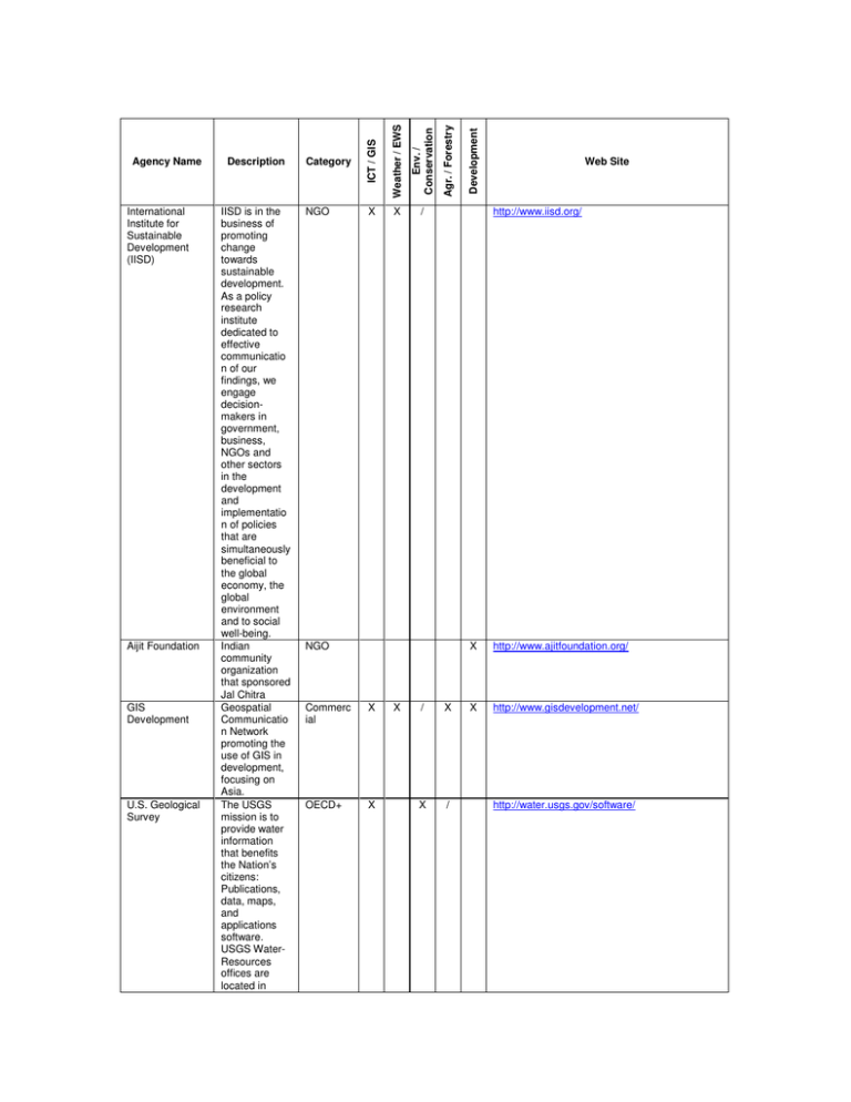
Agency Name Description Category Web Site
advertisement

Aijit Foundation GIS Development U.S. Geological Survey X X / X OECD+ X X Web Site http://www.iisd.org/ NGO Commerc ial Development NGO Agr. / Forestry Env. / Conservation IISD is in the business of promoting change towards sustainable development. As a policy research institute dedicated to effective communicatio n of our findings, we engage decisionmakers in government, business, NGOs and other sectors in the development and implementatio n of policies that are simultaneously beneficial to the global economy, the global environment and to social well-being. Indian community organization that sponsored Jal Chitra Geospatial Communicatio n Network promoting the use of GIS in development, focusing on Asia. The USGS mission is to provide water information that benefits the Nation’s citizens: Publications, data, maps, and applications software. USGS WaterResources offices are located in Category Weather / EWS International Institute for Sustainable Development (IISD) Description ICT / GIS Agency Name / X X / X http://www.ajitfoundation.org/ X http://www.gisdevelopment.net/ http://water.usgs.gov/software/ IT for Change (ITFC) The Centre for Communication and Development Studies (CCDS) Information Societies Technology European Commission (CORDIS) every State. ITfC (IT for Change) is a non-profit organisation located in India. ITfC envisions a society capable of, and comfortable with, innovative and effective use of information and communicatio n technologies (ICT) as a tool, to further goals of progressive social change. A social change resource centre focusing on the research and communicatio n of information for change. CCDS uses communicatio n tools and processes to inform, initiate and inspire change in societal attitudes and public policy. Our activities are designed to strengthen civil society by promoting a deeper understanding of issues related to sustainable development, justice, equity and rights Website for coordinating EC Framework Programmes, with a specific section dedicated to ICT for NGO OECD+ X X Development X Agr. / Forestry NGO Env. / Conservation Category Weather / EWS Description ICT / GIS Agency Name Web Site / X http://www.itforchange.net/ / X http://www.ccds.in/ / http://cordis.europa.eu/fp7/ict/sustainable-growth /previous-fp6_en.html X / Env. / Conservation Agr. / Forestry Development The Food and Agriculture Organization of the United Nations (FAO) Sustainable Growth. website is listing of the GIS / ICT / SD related projects from the FP6. Includes references to Tsunami early warning systems and other projects. A geoinformation research portal that intends to ensure the establishment of a forum for a vigorous engagement by African researchers. The development of AGIRN intends to provide the geoinformation research community a mechanism to publish and access high quality work, to share in geoinformation knowledge and to engage in discussion through a widely accessible web based medium. Leads international efforts to defeat hunger. Serving both developed and developing countries, FAO acts as a neutral forum where all nations meet as equals to negotiate agreements and debate policy. Category Weather / EWS African Geo Information Research Network (AGIRN) Description ICT / GIS Agency Name NGO X X X X X http://www.agirn.org/ UN / X / X X http://www.fao.org/ Web Site Iconnect The Department for International Development (DFID) NGO X OECD+ X Development X Weather / EWS OECD+ Agr. / Forestry - Putting information within reach. - Sharing policy expertise. - Providing a meeting place for nations. - Bringing knowledge to the field CTA is an ACP-EU institution working in the field of information for development that operates under the ACP-EU Cotonou Agreement with headquarters in The Netherlands. They provide training and information resources for capacity building in agriculture, including the disbursement of awards in AfricanCaribbeanPacific countries. iConnect promotes the effective exchange of experiences and knowledge on the use of Information and Communicatio n Technologies for Development (ICT4D). Part of the UK Government that manages Britain’s aid to poor countries and works to get rid of Category Env. / Conservation CTA Description ICT / GIS Agency Name / X X X Web Site http://www.cta.int/ X http://www.iconnect-online.org/home X http://www.dfid.gov.uk/ Convention on Biological Diversity (CBD) Online access to Research in the Environment (OARE) American Society for Photogrammetry and Remote Sensing extreme poverty. Signed by 150 government leaders at the 1992 Rio Earth Summit, the Convention on Biological Diversity is dedicated to promoting sustainable development. OARE is a partnership project with Yale University, the World Health Organization (WHO), the Food and Agriculture Organization (FAO) and more than 35 publishers aiming to provide the developing world access to one of the world’s biggest collection of environmental information at little or no cost The mission of the ASPRS is to advance knowledge and improve understanding of mapping sciences and to promote the responsible applications of photogrammet ry, remote sensing, geographic information systems (GIS), and supporting technologies. Provides reviews of the available software for imaging and geospatial processing. (Somewhat UN X X NGO X X Commerc ial X / Development Category Agr. / Forestry Env. / Conservation Weather / EWS Description ICT / GIS Agency Name Web Site http://www.cbd.int/ X / http://www.oaresciences.org/en/ http://www.asprs.org/resources/software/index.ht ml The International Institute for Communication and Development (IICD) United Nations Environment Programme (UNEP) Consultative Group on International Agricultural Research (CGIAR) dated). A non-profit foundation that specialises in information and communicatio n. IICD creates practical and sustainable solutions using both modern media (such as computers, Internet, email and multimedia) and traditional media (such as radio and television) to connect people and enable them to benefit from ICT, thereby contributing to the Millenium Development Goals. To provide leadership and encourage partnership in caring for the environment by inspiring, informing, and enabling nations and peoples to improve their quality of life without compromising that of future generations. Mission to achieve sustainable food security and reduce poverty in developing countries through scientific research and researchrelated activities in the fields of agriculture, forestry, fisheries, UN X NGO Development X Agr. / Forestry NGO Env. / Conservation Category Weather / EWS Description ICT / GIS Agency Name Web Site X http://www.iicd.org/ X / / http://www.unep.org/ / X X http://www.cgiar.org/w Development Weather / EWS Agr. / Forestry The International Development Research Centre (IDRC) policy, and environment. A nonprofit scientific research organization focusing on the sustainable use of water and land resources in agriculture and on the water needs of developing countries. IWMI works with partners in the South to develop tools and methods to help these countries eradicate poverty through more effective management of their water and land resources. Canadian gov’t agency to help developing countries use science and technology to find practical, long-term solutions to the social, economic, and environmental problems they face. Support is directed toward developing an indigenous research capacity to sustain policies and technologies that developing countries need to build healthier, more equitable, and more prosperous societies. Env. / Conservation The International Water Management Institute (IWMI) Description NGO / / X X http://www.iwmi.cgiar.org/ OECD+ X / / X http://www.idrc.ca/ Category ICT / GIS Agency Name Web Site The Center for International Earth Science Information Network (CIESIN) GRID-Arendal GeSI, the Global e-Sustainability Initiative A center within the Earth Institute at Columbia University. CIESIN works at the intersection of the social, natural, and information sciences, and specializes in on-line data and information management, spatial data integration and training, and interdisciplinar y research related to human interactions in the environment. The mission of GRID-Arendal is to provide environmental information, communicatio ns and capacity building services for information management and assessment. Established to strengthen the United Nations through its Environment Programme (UNEP), our focus is to make credible, science-based knowledge understandabl e to the public and to decisionmaking for sustainable development. Organized to further sustainable development in the ICT sector. GeSI OECD+ X X UN Agency X X UN Agency X X Development Category Agr. / Forestry Env. / Conservation Weather / EWS Description ICT / GIS Agency Name / Web Site http://www.ciesin.columbia.edu/ http://www.gesi.org/ United Nations Environment Programme - X http://www.wmo.ch/ X X http://www.t4cd.org/Pages/HomePage.aspx/ / X http://www.unep-wcmc.org/ X NGO UN Agency Development X UN Agency Category Agr. / Forestry Env. / Conservation Technologies for Conservation and Development fosters global and open cooperation, informs the public of its members’ voluntary actions to improve their sustainability performance, and promotes technologies that foster sustainable development. The World Meteorological Organization (WMO) is a specialized agency of the United Nations. It is the UN system’s authoritative voice on the state and behaviour of the Earth’s atmosphere, its interaction with the oceans, the climate it produces and the resulting distribution of water resources. The Technologies for Conservation & Development project (t4cd) is a joint initiative of the international conservation organisation Fauna & Flora International (FFI) and the South Africa based development NGO ResourceAfric a (RA). Mission to evaluate and highlight the Weather / EWS World Meteorological Organization Description ICT / GIS Agency Name Web Site World Conservation Monitoring Centre World Resources Institute (WRI) Integrated Approaches to Participatory Development (IAPAD) European Commission’s Environment Directorate-Gen eral (DG) GLOBAL SPATIAL DATA INFRASTRUCT URE ASSOCIATION (GSDI) many values of biodiversity and put authoritative biodiversity knowledge at the centre of decisionmaking The World Resources Institute (WRI) is an environmental think tank that goes beyond research to find practical ways to protect the earth and improve people’s lives. Uses GIS and 3D modeling for CBRM and conflict resolution. EU’s agency for environmental issues The GSDI Association is an inclusive organization of organizations, agencies, firms, and individuals from around the world. The purpose of the organization is to promote international cooperation and collaboration in support of local, national and international spatial data infrastructure developments that will allow nations to better address social, economic, and environmental issues of pressing NGO X NGO X X OECD+ / X NGO X X / / Development Agr. / Forestry Env. / Conservation Category Weather / EWS Description ICT / GIS Agency Name Web Site X http://www.wri.org/ X www.iapad.org http://ec.europa.eu/dgs/environment/index_en.ht m/ / http://www.gsdi.org/ Agr. / Forestry Development X Env. / Conservation Category Weather / EWS Description ICT / GIS Agency Name / / / / X / Web Site importance. ICT Netherlands By means of education, research and project services, they contribute to capacity building in countries that are economically and/or technologically less advanced. In doing so, considerable attention is paid to the development and application of geographical information systems (GIS) for solving problems. Such problems can range from determining the risks of landslides, mapping forest fires, planning urban infrastructure, and implementing land administration systems, to designing a good wildlife management system or detecting environmental pollution. NGO United Nations Convention to Combat Desertification (UNCCD) Committee on Science and Technology (CST) The UN Convention to Combat Desertification has established a Committee on Science and Technology (CST). The CST was established under Article UN http://www.itc.nl/about_itc/default.asp/ http://www.unccd.int/ X X Development / Agr. / Forestry Env. / Conservation 24 of the Convention as a subsidiary body of the COP, and its mandate and terms of reference were defined and adopted during the first session of the Conference of the Parties in 1997. It is composed of government representative s competent in the fields of expertise relevant to combating desertification and mitigating the effects of drought. The committee identifies priorities for research, and recommends ways of strengthening cooperation among researchers. It is multidisciplinary and open to the participation of all Parties. It meets in conjunction with the ordinary sessions of the COP. A network to provide a platform for scientific discussions and exchange of ideas, foster cutting edge science, identify topics and research areas, identify and document scientific state of the art of the main Category Weather / EWS European DesertNet Description ICT / GIS Agency Name Web Site http://www.europeandesertnet.eu/wgroups_eu.php?wg_nr=2/ / Weather / EWS Development UN (Chair is nominate d by World Bank) Agr. / Forestry topics in desertification assessment, risk evaluation, mitigation and restoration, identify and articulate the economic drivers and the socioeconomic consequences of desertification, integrate scientific findings across disciplines, translate into common language and communicate scientific findings, and work in and on affected areas inside and outside Europe. The Consultative Group on International Agricultural Research (CGIAR), established in 1971, is a strategic partnership of countries, international and regional organizations and private foundations supporting the work of 15 international Centers. In collaboration with national agricultural research systems, civil society and the private sector, the CGIAR fosters sustainable agricultural growth through high-quality science aimed Category Env. / Conservation CGIAR Description ICT / GIS Agency Name / X X Web Site GEO X X / UN Development OECD+ Agr. / Forestry Env. / Conservation at benefiting the poor through stronger food security, better human nutrition and health, higher incomes and improved management of natural resources. From daily weather forecasts, severe storm warnings and climate monitoring to fisheries management, coastal restoration and supporting marine commerce, NOAA’s products and services support economic vitality and affect more than one-third of America’s gross domestic product. NOAA’s dedicated scientists use cutting-edge research and high-tech instrumentatio n to provide citizens, planners, emergency managers and other decisionmakers with reliable information they need when they need it The Group on Earth Observations is coordinating efforts to build a Global Earth Observation Category Weather / EWS National Oceanic and Atmospheric Administration (US) Description ICT / GIS Agency Name Web Site http://www.noaa.gov/ http://www.earthobservations.org/ OECD+ X X OECD+ / X Development Category Agr. / Forestry Env. / Conservation Weather / EWS Description ICT / GIS Agency Name Web Site System of Systems, or GEOSS. NBII Japan NIES GEO was launched in response to calls for action by the 2002 World Summit on Sustainable Development and the G8 (Group of Eight) leading industrialized countries. These highlevel meetings recognized that international collaboration is essential for exploiting the growing potential of Earth observations to support decision making in an increasingly complex and environmentall y stressed world. The National Biological Information Infrastructure (NBII) is a broad, collaborative program to provide increased access to data and information on the nation’s biological resources. National Institute for Environmental Studies (NIES) has integrative expertise to tackle environmental issues through the collaboration of our http://www.nbii.org/portal/server.pt / http://www.nies.go.jp/index.html GTZ ECMWF Tropical Storm Risd researchers and staffs with diversified specialties such as physics, chemistry, engineering, agriculture, fisheries, medicine, pharmacology, law/politics and economics. German development agency The GTZ is an international cooperation enterprise for sustainable development with worldwide operations. GTZ promotes complex reforms and change processes, often working under difficult conditions. Its corporate objective is to improve people’s living conditions on a sustainable basis. European Centre for MediumRange Weather Forecasts The TSR consortium comprises experts on insurance, risk management and seasonal climate forecasting. The TSR industry expertise is drawn from Benfield, the leading independent reinsurance intermediary, OECD+ / / Development Agr. / Forestry Env. / Conservation Category Weather / EWS Description ICT / GIS Agency Name X Web Site http://www.gtz.de OECD+ X http://www.ecmwf.int/ NGO X http://tsr.mssl.ucl.ac.uk/ Web2fordev PTWS Royal & SunAlliance, the global insurance group, and from Crawford & Company, a global claims management solutions company. The TSR scientific grouping brings together climate physicists, meteorologists and statisticians from the UCL, Benfield UCL Hazard Research Centre and the Met Office. Networking, collaborating and exchanging knowledge in agriculture, rural development and natural resources management Intergovernme ntal Coordination Group for the Pacific Tsunami Warning System (ICG/PTWS) Under the auspices of the Intergovernme ntal Oceanographi c Commission (IOC), the Intergovernme ntal Coordination Group for the Pacific Tsunami Warning and Mitigation System first convened in 1968 (ICG/PTWS, / / X / Development X Agr. / Forestry NGO Env. / Conservation Category Weather / EWS Description ICT / GIS Agency Name X Web Site http://www.web2fordev.ne http://ioc3.unesco.org/itic/categories.php?catego ry_no=172 IRC formerly known as ICG/ITSU for International Tsunami). The Committee on Earth Observation Satellites (CEOS) is an international coordinating mechanism charged with coordinating international civil spaceborne missions designed to observe and study planet Earth. Comprising 26 Members (most of which are space agencies) and 20 Associates (associated national and international organizations), CEOS is recognized as the major international forum for the coordination of Earth observation satellite programs and for interaction of these programs with users of satellite data worldwide. Since its foundation in 1968, the IRC International Water and Sanitation Centre (IRC) has facilitated the sharing, promotion and use of knowledge so that governments, professionals X Development X Agr. / Forestry X Env. / Conservation Category Weather / EWS CEOS Description ICT / GIS Agency Name Web Site http://www.ceos.org/ X / / http://www.irc.nl/page/103 IGES RTF and organisations can better support poor men, women and children in developing countries to obtain water and sanitation services they will use and maintain. The Institute for Global Environmental Strategies (IGES), established by an initiative of the Japanese Government in 1998, is a research institute that conducts pragmatic and innovative strategic policy research to support sustainable development in the AsiaPacific regiona region experiencing rapid population growth and expanding economic activity. Radar Technologies France or RTF is a France-based company with international activities. RTF specializes in Remote Sensing technologies, specifically radar/optic imagery interpretations monitoring the global environment with particular expertise in Oil Development Agr. / Forestry Env. / Conservation Category Weather / EWS Description ICT / GIS Agency Name Web Site OECD+ / X X http://www.iges.or.jp/en/outline/index.html Private X X / http://www.radar-technologies.com/ / / X Developi ng Nations X X OECD+ / X Development Developi ng Nations Category Agr. / Forestry Center for Global Development Env. / Conservation National Remote Sensing Agency (Department of Space for India) & Gas, base metals and ground water exploration all over the world. Le Comité Permanent Inter Etats de lutte contre la Sécheresse dans le Sahel(CILSS) a été créé le 12 septembre 1973 à la suite des grandes sécheresses qui ont frappé le Sahel dans les années 70. Le CILSS regroupe aujourd’hui neuf Etats dont 4 Etats côtiers: (Gambie, Guinée-Bissau , Mauritanie, Sénégal); 4 Etats enclavés : (Burkina Faso ; Mali ; Niger ; Tchad) ; 1 Etat insulaire: (Cap Vert). Agency with Mandate to provide remote sensing and processing services for India. Welldeveloped set of tools that include basic image rendering and geo-tagging to value-added processing (e.g. vegetation cover analysis). CGD is an independent, not-for-profit think tank that works to reduce global poverty and inequality by Weather / EWS CILSS Description ICT / GIS Agency Name / X http://www.cilss.bf/htm/mandat.htm / http://www.nrsa.gov.in/products/level_processing .html#01/ X http://www.cgdev.org/ Web Site It is Weather / EWS Development NGO Agr. / Forestry GEF encouraging policy change in the U.S. and other rich countries through rigorous research and active engagement with the policy community. To reduce hunger and poverty in the tropics through collaborative research that improves agricultural productivity and natural resource management The Global Environment Facility (GEF), established in 1991, helps developing countries fund projects and programs that protect the global environment. GEF grants support projects related to biodiversity, climate change, international waters, land degradation, the ozone layer, and persistent organic pollutants. The ITIS is the result of a partnership of federal agencies formed to satisfy their mutual needs for scientifically credible taxonomic information. Since its Category Env. / Conservation CIAT Description ICT / GIS Agency Name Web Site / X X http://www.ciat.cgiar.org/about_ciat/mission.htm X X http://www.gefweb.org/ NGO / X OECD+ / X http://www.itis.gov/ OECD+ / / X OECD+ X X Category Development Weather / EWS Agr. / Forestry GBIF inception, ITIS has gained valuable new partners and undergone a name change; ITIS now stands for the Integrated Taxonomic Information System. The InterAmerican Biodiversity Information Network (IABIN) is a forum to foster technical collaboration and coordination among countries of the Americas in collection, sharing, and use of biodiversity information relevant to decisionmaking on natural resources management and conservation, and education to promote sustainable development in the region. GBIF, the Global Biodiversity Information Facility, was established in 2001 to take on a special set of tasks that will make it possible for policy- and decisionmakers, research scientists and the general public all around the world to electronically Env. / Conservation IABIN Description ICT / GIS Agency Name Web Site http://www.iabin.net/ http://www.gbif.org/ access the world’s supply of primary scientific data on biodiversity. Hosted at the University of Copenhagen Development Agr. / Forestry Env. / Conservation Category Weather / EWS Description ICT / GIS Agency Name Web Site


