An Open Source, Three - Tiered Approach to Satellite Data Collection,
advertisement

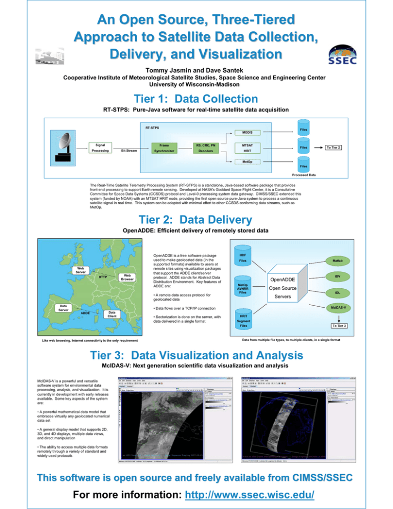
An Open Source, Three-Tiered Approach to Satellite Data Collection, Delivery, and Visualization Tommy Jasmin and Dave Santek Cooperative Institute of Meteorological Satellite Studies, Space Science and Engineering Center University of Wisconsin-Madison Tier 1: Data Collection RT-STPS: Pure-Java software for real-time satellite data acquisition RT-STPS Files MODIS Signal Processing Bit Stream Frame RS, CRC, PN MTSAT Synchronizer Decoders HRIT Files To Tier 2 MetOp Files Processed Data The Real-Time Satellite Telemetry Processing System (RT-STPS) is a standalone, Java-based software package that provides front-end processing to support Earth remote sensing. Developed at NASA's Goddard Space Flight Center, it is a Consultative Committee for Space Data Systems (CCSDS) protocol and Level-0 processing system data gateway. CIMSS/SSEC extended this system (funded by NOAA) with an MTSAT HRIT node, providing the first open source pure-Java system to process a continuous satellite signal in real time. This system can be adapted with minimal effort to other CCSDS conforming data streams, such as MetOp. Tier 2: Data Delivery OpenADDE: Efficient delivery of remotely stored data Web Server Web Browser HTTP OpenADDE is a free software package used to make geolocated data (in the supported formats) available to users at remote sites using visualization packages that support the ADDE client/server protocol. ADDE stands for Abstract Data Distribution Environment. Key features of ADDE are: • A remote data access protocol for geolocated data Data Server HDF Matlab Files OpenADDE MetOp AVHRR Files Open Source IDL Servers McIDAS-V • Data flows over a TCP/IP connection Data Client ADDE • Sectorization is done on the server, with data delivered in a single format HRIT Segment Files Like web browsing, Internet connectivity is the only requirement IDV To Tier 3 Data from multiple file types, to multiple clients, in a single format Tier 3: Data Visualization and Analysis McIDAS-V: Next generation scientific data visualization and analysis McIDAS-V is a powerful and versatile software system for environmental data processing, analysis, and visualization. It is currently in development with early releases available. Some key aspects of the system are: • A powerful mathematical data model that embraces virtually any geolocated numerical data set • A general display model that supports 2D, 3D, and 4D displays, multiple data views, and direct manipulation • The ability to access multiple data formats remotely through a variety of standard and widely used protocols This software is open source and freely available from CIMSS/SSEC For more information: http://www.ssec.wisc.edu/


