Rapid Assessment Reference Condition Model
advertisement
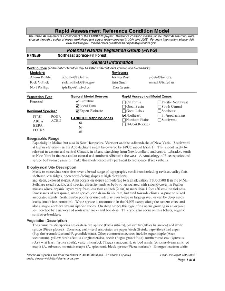
Rapid Assessment Reference Condition Model The Rapid Assessment is a component of the LANDFIRE project. Reference condition models for the Rapid Assessment were created through a series of expert workshops and a peer-review process in 2004 and 2005. For more information, please visit www.landfire.gov. Please direct questions to helpdesk@landfire.gov. Potential Natural Vegetation Group (PNVG) R7NESF Northeast Spruce-Fir Forest General Information Contributors (additional contributors may be listed under "Model Evolution and Comments") Modelers Reviewers Alison Dibble Rick Vollick Nort Phillips adibble@fs.fed.us rick_vollick@fws.gov tphillips@fs.fed.us Vegetation Type Forested Dominant Species* PIRU ABBA BEPA POTR5 POGR ACRU Joshua Royt Erin Small Dan Grenier General Model Sources Literature Local Data Expert Estimate LANDFIRE Mapping Zones 64 65 66 jroyte@tnc.org esmall@fs.fed.us Rapid AssessmentModel Zones California Great Basin Great Lakes Northeast Northern Plains N-Cent.Rockies Pacific Northwest South Central Southeast S. Appalachians Southwest Geographic Range Especially in Maine, but also in New Hampshire, Vermont and the Adirondacks of New York. [Southward at higher elevations in the Appalachians might be covered by FRCC model ESPF1]. This model might be relevant in eastern and central Canada, in a band stretching from Newfoundland and central Labrador, south to New York in the east and to central and northern Alberta in the west. A Autecology of Picea species and spruce budworm dynamics make this model especially pertinent to red spruce (Picea rubens. Biophysical Site Description Mesic to somewhat xeric sites over a broad range of topographic conditions including ravines, valley flats, sheltered low ridges, open north-facing slopes at high elevations, and steep, exposed slopes. Also occurs on slopes at moderate to high elevation (1800-3500 ft in the N.NE. Soils are usually acidic and species diversity tends to be low. Associated with ground-covering feather mosses where organic layers vary from less than an inch (2 cm) to more than 1 foot (30 cm) in thickness. Pure stands of red spruce, white spruce, or balsam fir are rare, but tend towards climax as pure or mixed associated stands. Soils can be poorly drained silt clay over ledge or large gravel, or can be deep sandy loams (much less common). White spruce is uncommon in the N.NE except along the eastern coast and along major northern stream riparian zones. On steep slopes this type often occur growing in an organic soil perched by a network of roots over rocks and boulders. This type also occur on thin folists; organic soils over boulders. Vegetation Description The characteristic species are eastern red spruce (Picea rubens), balsam fir (Abies balsamea) and white spruce (Picea glauca). Common, early-seral associates are paper birch (Betula papyrifera) and aspen (Populus tremuloides and P. grandidentata). Other common associates include sugar maple (Acer saccharum), yellow birch (Betula alleghaniensis), beech (Fagus grandifolia), northern red oak (Quercus rubra -- at least, farther south), eastern hemlock (Tsuga canadensis), striped maple (A. pensylvanicum), red maple (A. rubrum), mountain maple (A. spicatum), black spruce (Picea mariana). Emergent eastern white *Dominant Species are from the NRCS PLANTS database. To check a species code, please visit http://plants.usda.gov. Final Document 9-30-2005 Page 1 of 5 pine (Pinus strobus) may be present. Short-lived early successional shrubby trees include pin cherry (Prunus serotina), and on wet sites speckled alder (Alnus incana ssp. rubra). Low shrubs often include sweet fern (Comptonia peregrina -- an atmospheric Nitrogen-fixer), red and black raspberry (Rubus spp.). Two common ferns with reputed allelopathic properties are bracken (Pteridium aquilinum) and hay-scented fern (Dennstaedtia punctilobula). Red spruce can persist in a shady understory for 100 years (called umbrella spruce), and then quickly fill a gap when an opportunity arises. It can then grow into the canopy over a short period. White and black spruce do not do this. Balsam fir is an early competitor and grows faster than young red spruce, but dies at ca. 90 years or earlier, and the red spruce can then dominate the stand. Disturbance Description Fire Regime Group V. A moist, cool climate precludes frequent fire. However, rare fire disturbances are severe and affect large patch sizes, at 150- to 300+-year intervals. Surface fires are extremely uncommon. Fire may occur in the spring or later in the growing season under drought conditions, with the former favoring a pathway to early successional aspen-birch, and this delays spruce-fir regeneration (see Class C). Large fires (10-100 acres) and some wind events could extend class D to 130 years before the paper birch finally senesces and the dense fir understory emerges. It is then a further 50-150 years before the fir either senesces or is knocked back by budworm. Wind events, insect attack and ice storms -- on a small patch to stand scale -- are more important than fire, and they may predispose the forest to fire especially when coupled with drought. Wind disturbance often results in an abundance of mountain ash (Sorbus decora and S. canadensis) as well as elderberry (Sambucus pubescens and S. canadensis). Spruce budworm outbreaks today are on a 40 to 60 year cycle -- historic cycle is thought to be much longer. The preferred host plant of spruce budworm is balsam fir, but this native insect also attacks over-mature spruce. Before 1800, outbreaks may have had less epidemic impact than in recent times, and interval between outbreaks was longer. Minor spruce budworm outbreaks are also of considerable importance particularly in classes B and D where fir is at it's peak of attractiveness to the budworm. One or two cycles of budworm over a 50 - 150 year period slowly decreases the dominance or co-dominance of fir and increases in waves the strong dominance of red and potentially some black spruce. Spruce beetle attacks trees > 18 in DBH. Overmature or stressed spruce is susceptible to witch's broom, Armillaria, and in severe outbreaks the stand can collapse. In the Rainbow Flora book, susceptibility to fire is estimated to be highest 5 to 8 years after tree mortality; then flammability gradually decreases as fuel decomposes and new understory develops. Sustained crown fire runs covering several hundred acres can occur, with severe damage at the ground surface, depending on time of year. Drought spring conditions produce the most severe effects, whereas late summer or fall burns may temper effects due to presence of live fuel moisture. In the relatively stable late-closed class, moderate disturbances from wind, spruce budworm, spruce bark beetle, Armillaria, and ice storm impact on this community but not to stand-replacing severity. On deep and coarse glacial outwash where fire return intervals can be quicker and more intense it may take much longer to get back to the Spruce forest type. The more intense fires will often strip organic soils and spruce resulting in red and white pine domination for periods of between 100 and 200 years. Synergy plays a key role in the fire regimes associated with this model (i.e. spruce budworm outbreak , then a wind event, followed by a fire. Adjacency or Identification Concerns The type occurs within a zone influenced by temperature-moderating effects of the Atlantic ocean, high relative humidity, high precipitation (most years), and elevation differences. The type covers species transition zones, and ranges from the Acadian spruce-fir forest, to northern hardwoods to boreal hardwoods and conifers. Local Data Expert Estimate Literature Sources of Scale Data Scale Description The type occupies patches from a few acres to tens of thousands of acres, depending on growing site *Dominant Species are from the NRCS PLANTS database. To check a species code, please visit http://plants.usda.gov. Final Document 9-30-2005 Page 2 of 5 quality, soils, elevation, and moisture. Issues/Problems The historic distribution of this type, if defined by red spruce dominance, is not well-known. Pollen data from cores are not able to differentiate spruce species. Perhaps there was less abundance of balsam fir and red maple in reference conditions. These two species appear to respond especially well to anthropogenic disturbance. Early successional trees such as red maple and poplar can sucker easily after a fire and/or have windborne seeds. Model Evolution and Comments KellyAnn Gorman refined the model with us on Feb 17 2005. This model is based on FRCC Reference Conditions for NESF by William Patterson III. Reviews should be sought especially from Patterson, and also from Robert Seymour and Robert Wagner, both of Department of Forest Ecosystem Science, University of Maine, Orono, and from Charles Cogbill. Some of the descriptive info is based on Chapter 5 in Rainbow Vol. 2, Wildland Fire in Ecosystems, and the FRCC version was prepared by Bill Patterson III. Peer reviewed by Joshua Royt, Conservation Planner TNC Maine Chapter 04/18/15, Erin Small Fire Planner USDS Forest Service White Mountain/Green Mountain/Finger Lakes National Forest 04/25/05, and Dan Grenier 04/26/05. Succession Classes** Succession classes are the equivalent of "Vegetation Fuel Classes" as defined in the Interagency FRCC Guidebook (www.frcc.gov). Class A 10 % Early1 All Struct Description The community type, 0-29 years old, occupies an opening that followed stand replacement fire, microburst, or another major disturbance. Young stands characterized by birch (paper, gray) and aspen ( trembling, bigtooth). Understory has spruce (red/white/black, but especially red) and balsam fir. Class B 12 % Mid1 Closed Description From A without disturbance. Intermediate stands dominated by birch and aspen with spruce and fir in the understory. Age range 30 – 69 yrs old. Dominant Species* and Canopy Position P1RU ABBA BEPA POTR5 Lower Lower Upper Upper Upper Layer Lifeform Herbaceous Shrub Tree Fuel Model Upper Upper Low-Mid Low-Mid Upper Layer Lifeform Herbaceous Shrub Tree Fuel Model Min 30 % Cover Height Max 80 % Tree Regen <5m Tree Size Class Tree Short 5-9m Seedling <4.5ft Upper layer lifeform differs from dominant lifeform. Height and cover of dominant lifeform are: An example is in Baxter State Park, in the Scientific Forest Management Area, northern Maine. 8 Dominant Species* and Canopy Position BEPA POTR5 P1RU ABBA Structure Data (for upper layer lifeform) Structure Data (for upper layer lifeform) Min 60 % Cover Height Max 100 % Tree Short 5-9m Tree Size Class Tree Medium 10-24m Pole 5-9" DBH Upper layer lifeform differs from dominant lifeform. Height and cover of dominant lifeform are: 9 *Dominant Species are from the NRCS PLANTS database. To check a species code, please visit http://plants.usda.gov. Final Document 9-30-2005 Page 3 of 5 Class C 3% Dominant Species* and Canopy Position BEPA Upper POTR5 Upper Description This alternate successional pathway POGRA Upper PIRU Lower may follow fire (frequency 175 yrs) in A, and reflects suppressed Upper Layer Lifeform establishment of spruce-fir. Herbaceous Intermediate stands characterized Shrub by birch and aspen. Understory Tree initially LACKS spruce and fir but the conifers establish later in the class, perhaps around 40 years. Fuel Model 5 Class age range: 30-79 yrs. Mid2 Closed Class D 10 % Late1 Closed Description Primary pathway from C, so may have burned. Late closed stand dominated by aspen and birch. Spruce/fir present and gaining dominance. Early-successional hardwoods are in decline. Age range for the class is 80-119 yrs. Class E 65 % Late2 Closed Description Closed spruce/fir stand 70-175+ years. Individual fir trees drop out after age 70-100, but spruce and fir regenerate in gaps, eventually to spruce and secondarily to fir. Moderate disturbances from wind, spruce budworm, spruce bark beetle, Armillaria, and ice storm impact on this community but not to stand-replacing severity. Dominant Species* and Canopy Position BEPA POTR5 P1RU ABBA Upper Upper Mid-Upper Mid-Upper Upper Layer Lifeform Herbaceous Shrub Tree Fuel Model Structure Data (for upper layer lifeform) Min 40 % Cover Height Max 80 % Tree Regen <5m Tree Size Class Tree Short 5-9m Sapling >4.5ft; <5"DBH Upper layer lifeform differs from dominant lifeform. Height and cover of dominant lifeform are: If we could have added one more species, it would be ABBA in lower canopy position, with PIRU. Structure Data (for upper layer lifeform) Cover Height Min 70 % Max 100 % Tree Medium 10-24m Tree Size Class Tree Medium 10-24m Pole 5-9" DBH Upper layer lifeform differs from dominant lifeform. Height and cover of dominant lifeform are: 9 Dominant Species* and Canopy Position Structure Data (for upper layer lifeform) P1RU Upper ABBA Mid-Upper Cover Height Min 80 % Tree Medium 10-24m Tree Size Class Upper Layer Lifeform Herbaceous Shrub Tree Fuel Model Max 100 % Tree Tall 25-49m Large 21-33"DBH Upper layer lifeform differs from dominant lifeform. Height and cover of dominant lifeform are: 10 Disturbances *Dominant Species are from the NRCS PLANTS database. To check a species code, please visit http://plants.usda.gov. Final Document 9-30-2005 Page 4 of 5 Disturbances Modeled Fire Insects/Disease Wind/Weather/Stress Native Grazing Competition Other: Other Historical Fire Size (acres) Avg: no data Min: no data Max: no data Sources of Fire Regime Data Literature Local Data Expert Estimate Fire Regime Group: 5 I: 0-35 year frequency, low and mixed severity II: 0-35 year frequency, replacement severity III: 35-200 year frequency, low and mixed severity IV: 35-200 year frequency, replacement severity V: 200+ year frequency, replacement severity Fire Intervals (FI) Fire interval is expressed in years for each fire severity class and for all types of fire combined (All Fires). Average FI is central tendency modeled. Minimum and maximum show the relative range of fire intervals, if known. Probability is the inverse of fire interval in years and is used in reference condition modeling. Percent of all fires is the percent of all fires in that severity class. All values are estimates and not precise. Replacement Mixed Avg FI Min FI Max FI Probability 265 150 300 0.00377 Percent of All Fires 99 Surface All Fires 265 0.00379 References Bergeron, Y. 2000. Species and dynamics in the mixed woods of Quebec's southern boreal forest. Ecology. 81: 1500-1516. Brown, James K.; Smith, Jane Kapler, eds. 2000. Wildland fire in ecosystems: effects of fire on flora. Gen. Tech. Rep. RMRS-GTR-42-vol. 2. Ogden, UT: U.S. Department of Agriculture, Forest Service, Rocky Mountain Research Station. 257 p. Heinselman, M. L. 1981. Fire intensity and frequency as factors in the distribution and structure of Northern ecosystems. In: Mooney, H. A., T. M. Bonnickson, N. L. Christensen, J. E. Lotan, and R. A. Reiners, tech. coords. Fires regimes and ecosystem properties: proceedings of the conference; 1978 Dec 11-15; Honolulu, HI. Gen. Tech. Rep.WO-26, Washington, DC: U.S. Dept. of Agriculture, Forest Service, 7-57. Kuchler, A.W. 1964. Northern hardwoods (Acer-Betula-Fagus-Tsuga). #106 In: Manual to accompany the map Potential Natural Vegetation of the United States. New York, NY: The American Geographical Society. 156 p. Lorimer and White. 2003. Scale and Frequency of natural disturbances in the northeastern US. Forest Ecology and Management: 185:41-64 Patterson, W. A. III, K. E. Saunders and L. J. Horton. 1983. Fire Regimes of the Coastal Maine Forests of Acadia National Park. USDI/NPS - North Atlantic Region Office of Scientific Studies Report OSS 83-3. 259 pp. U.S. Department of Agriculture, Forest Service, Rocky Mountain Research Station, Fire Sciences Laboratory (2002, December). Fire Effects Information System, [Online 12 February 2004]. Available: http://www.fs.fed.us/database/feis/. *Dominant Species are from the NRCS PLANTS database. To check a species code, please visit http://plants.usda.gov. Final Document 9-30-2005 Page 5 of 5
