An Analysis and Exploration of Scintillation Data From the CASES... Introduction
advertisement
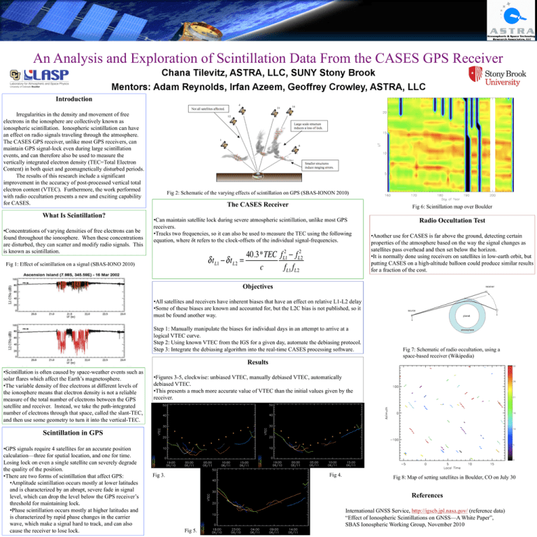
An Analysis and Exploration of Scintillation Data From the CASES GPS Receiver Introduction Irregularities in the density and movement of free electrons in the ionosphere are collectively known as ionospheric scintillation. Ionospheric scintillation can have an effect on radio signals traveling through the atmosphere. The CASES GPS receiver, unlike most GPS receivers, can maintain GPS signal-lock even during large scintillation events, and can therefore also be used to measure the vertically integrated electron density (TEC=Total Electron Content) in both quiet and geomagnetically disturbed periods. The results of this research include a significant improvement in the accuracy of post-processed vertical total electron content (VTEC). Furthermore, the work performed with radio occultation presents a new and exciting capability for CASES. What Is Scintillation? • Concentrations of varying densities of free electrons can be found throughout the ionosphere. When these concentrations are disturbed, they can scatter and modify radio signals. This is known as scintillation. Fig 2: Schematic of the varying effects of scintillation on GPS (SBAS-IONON 2010) The CASES Receiver Fig 6: Scintillation map over Boulder • Can maintain satellite lock during severe atmospheric scintillation, unlike most GPS receivers. • Tracks two frequencies, so it can also be used to measure the TEC using the following equation, where δt refers to the clock-offsets of the individual signal-frequencies. Fig 1: Effect of scintillation on a signal (SBAS-IONO 2010) Radio Occultation Test • Another use for CASES is far above the ground, detecting certain properties of the atmosphere based on the way the signal changes as satellites pass overhead and then set below the horizon. • It is normally done using receivers on satellites in low-earth orbit, but putting CASES on a high-altitude balloon could produce similar results for a fraction of the cost. Objectives • All satellites and receivers have inherent biases that have an effect on relative L1-L2 delay • Some of these biases are known and accounted for, but the L2C bias is not published, so it must be found another way. Step 1: Manually manipulate the biases for individual days in an attempt to arrive at a logical VTEC curve. Step 2: Using known VTEC from the IGS for a given day, automate the debiasing protocol. Step 3: Integrate the debiasing algorithm into the real-time CASES processing software. Results • Scintillation is often caused by space-weather events such as solar flares which affect the Earth’s magnetosphere. • The variable density of free electrons at different levels of the ionosphere means that electron density is not a reliable measure of the total number of electrons between the GPS satellite and receiver. Instead, we take the path-integrated number of electrons through that space, called the slant-TEC, and then use some geometry to turn it into the vertical-TEC. Fig 7: Schematic of radio occultation, using a space-based receiver (Wikipedia) • Figures 3-5, clockwise: unbiased VTEC, manually debiased VTEC, automatically debiased VTEC. • This presents a much more accurate value of VTEC than the initial values given by the receiver. Scintillation in GPS • GPS signals require 4 satellites for an accurate position calculation—three for spatial location, and one for time. Losing lock on even a single satellite can severely degrade the quality of the position. • There are two forms of scintillation that affect GPS: • Amplitude scintillation occurs mostly at lower latitudes and is characterized by an abrupt, severe fade in signal level, which can drop the level below the GPS receiver’s threshold for maintaining lock. • Phase scintillation occurs mostly at higher latitudes and is characterized by rapid phase changes in the carrier wave, which make a signal hard to track, and can also cause the receiver to lose lock. Fig 4. Fig 3. Fig 8: Map of setting satellites in Boulder, CO on July 30 References International GNSS Service, http://igscb.jpl.nasa.gov/ (reference data) “Effect of Ionospheric Scintillations on GNSS—A White Paper”, SBAS Ionospheric Working Group, November 2010 Fig 5.
