CIPS v4.20 Level 3d Common Volume Summary Files I. Introduction
advertisement

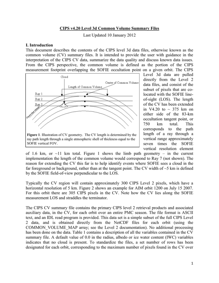
CIPS v4.20 Level 3d Common Volume Summary Files Last Updated 10 January 2012 I. Introduction This document describes the contents of the CIPS level 3d data files, otherwise known as the common volume (CV) summary files. It is intended to provide the user with guidance in the interpretation of the CIPS CV data, summarize the data quality and discuss known data issues. From the CIPS perspective, the common volume is defined as the portion of the CIPS measurement footprint overlapping the SOFIE occultation point on a given orbit. The CIPS Level 3d data are pulled directly from the Level 2 data files, and consist of the subset of pixels that are colocated with the SOFIE lineof-sight (LOS). The length of the CV has been extended in V4.20 to ~ 375 km on either side of the 83-km occultation tangent point, or 750 km total. This corresponds to the path length of a ray through a Figure 1. Illustration of CV geometry. The CV length is determined by the vertical range approximately ray path length through a single atmospheric shell of thickness equal to the SOFIE vertical FOV. seven times the SOFIE vertical resolution element of 1.6 km, or ~11 km total. Figure 1 shows the limb path geometry – in the current implementation the length of the common volume would correspond to Ray 7 (not shown). The reason for extending the CV this far is to help identify events where SOFIE sees a cloud in the far foreground or background, rather than at the tangent point. The CV width of ~5 km is defined by the SOFIE field-of-view perpendicular to the LOS. Typically the CV region will contain approximately 300 CIPS Level 2 pixels, which have a horizontal resolution of 5 km. Figure 2 shows an example for AIM orbit 1200 on July 15 2007. For this orbit there are 305 CIPS pixels in the CV. Note how the CV lies along the SOFIE measurement LOS and straddles the terminator. The CIPS CV summary file contains the primary CIPS level 2 retrieval products and associated auxiliary data, in the CV, for each orbit over an entire PMC season. The file format is ASCII text, and an IDL read program is provided. This data set is a simple subset of the full CIPS Level 2 data, and is obtained directly from the NetCDF files for each orbit (using the COMMON_VOLUME_MAP array; see the Level 2 documentation). No additional processing has been done on the data. Table 1 contains a description of all the variables contained in the CV summary file. A default value of 0.0 in the radius, albedo or ice water content (IWC) variables indicates that no cloud is present. To standardize the files, a set number of rows has been designated for each orbit, corresponding to the maximum number of pixels found in the CV over 1 the season; a default value of -1.00 across the row indicates that there are no more pixels in the common volume for that particular orbit. II. CV data quality and known issues Users are strongly encouraged to read the Level 2 data product documentation for a description of the Level 2 products and guidance in their interpretation. Because SOFIE uses the solar occultation technique, for which measurements by definition occur at the terminator, the CIPS CV data set is comprised of measurements made near 90° solar zenith angle (see Figure 2). As discussed in the Level 2 data documentation, the CIPS version 4.20 cloud parameter retrievals are considered valid up to solar zenith angles of 94°. With the extended LOS path length used in version 4.20 (see discussion above), the range of solar zenith angles sampled is between 86° and 93.5° and therefore we consider all CV data to be of good quality. In fact the CIPS retrievals should perform best in the region of the common volume, as the background atmospheric Figure 2. Typical example of CV geometry, for AIM orbit radiance is dim and CIPS samples a 1200. The red circle is the location of the SOFIE full range of forward scattering occultation (83-km tangent point). Small blue crosses angles at this point in the orbit. represent all the CIPS level 2 pixel locations, with the CIPS CV pixels denoted by blue circles. Shading indicates the location of the day/night terminator. One data quality issue that does affect the version 4.20 common volume data involves cloud pixels where a particle radius less than 20 nm is retrieved. As discussed in the Level 2 documentation, this is thought to be caused by occasional errors in the background Rayleigh subtraction. Because the retrieved particle radius and ice water content are considered unreliable for these pixels, they are screened in the Level 3d summary file. The CLD_MAP value (see Table 1) remains at 1 for these pixels, indicating cloud detection, however the radius and ice water content values are set to a default -999. Note that this is consistent with the data screening employed in the Level 3c summary files. The location of the SOFIE solar occultation point relative to the AIM sub-satellite point is a function of the solar beta angle, hemisphere and time of year. The CIPS CV data are obtained by rolling the AIM spacecraft either early (NH) or late (SH) in the orbit to center the CIPS field-ofview on this point. Because of degradation of the AIM orbit with time, by February 2010 the beta angle had increased to the point where this satellite roll maneuver was no longer possible. Therefore the CIPS Level 3d data are only available for the first three seasons (2007-2009) in each hemisphere. 2 III. Sample results In this section we show sample results of CIPS CV data for the 2008 Northern Hemisphere (NH) season, including some initial comparisons with the SOFIE data. Figure 3 compares the cloud frequency and cloud mode radius retrieved by the two instruments. Several features are apparent in this figure. First, SOFIE generally detects more clouds than CIPS in the CV region, presumably due to the higher sensitivity of the SOFIE instrument. While the temporal morphology of the daily cloud frequency (panel (a)) observed by the two instruments is very similar, the SOFIE frequency is always higher than CIPS, especially in the early-season, where SOFIE frequencies ramp up much faster than CIPS. Note, however, that the season beginning and end dates observed in the two data sets are very similar. It is interesting to note that, over the course of the entire season, CIPS detects a cloud in the CV on 79% of the orbits that SOFIE sees a cloud. Conversely, SOFIE detects clouds on 98% of the orbits for which CIPS records clouds in the CV. Finally, CIPS generally sees larger particles than SOFIE. The CIPS radius distribution peaks at ~35 to 45 nm, with a significant fraction of observations showing particles of 60 nm or larger. SOFIE on the other hand sees a broader range of smaller particles, with a distribution peaked at ~20 nm. Remember, of course that the CIPS distribution at the lower end is truncated because we have eliminated all observations with retrieved radius less than Figure 3. Comparison of CIPS and SOFIE retrievals of cloud frequency 20 nm. There are strong and particle mode radius in the CV for the NH 2008 season. (a) Daily cloud frequency for CIPS (red) and SOFIE (blue). (b) CIPS mean radius for physical arguments why cloudy pixels (red) and SOFIE retrieved radius at peak extinction altitude CIPS should not be (blue). (c) Fraction of total retrievals at a given radius (5-nm bins) for CIPS sensitive to particles this (red) and SOFIE (blue). (d) CIPS-SOFIE % difference in radius for all small. coincident orbits (both instruments detect clouds in the CV). 3 Table 1. Definition of variables in CIPS Level 3d Common Volume summary file. Variable Name Units NPIX NREV NA NA REV DATE UT NA NA Hours LTIME Hours NCV NCLD NA NA CLD_PRESENCE NA CLD_FRAC NA CLD_MAP NA LAT Degrees LON Degrees SZA DIST Degrees km QF NA RADIUS nm ALBEDO 10-6 sr-1 IWC g/m2 Dimension/Type Description INTEGER/SCALAR INTEGER/SCALAR Maximum number of CV pixels. Total number of orbits in the season. INTEGER(NREV) AIM orbit number LONG(NREV) Date in YYYYMMDD format REAL(NREV) Mean UT time of CV measurements REAL(NREV) Mean local time of CV measurements INTEGER(NREV) Number of CV pixels INTEGER(NREV) Number of pixels where ice is detected. INTEGER(NREV) PMC present anywhere in the CV. (0 = no, 1 = yes) REAL(NREV) Fraction of CV pixels containing ice. [0.,1.] INTEGER(NREV,NPIX) Identifies cloud pixels (1 = cloud, 0 = no cloud) REAL(NREV,NPIX) Latitude of CV pixels [-90,90] REAL(NREV,NPIX) Longitude of CV pixels. [0,360] REAL(NREV,NPIX) Solar zenith angle of CV pixels. REAL(NREV,NPIX) Distance of CV pixels from SOFIE 83-km occultation point. INTEGER(NREV,NPIX) Level 2 QUALITY_FLAG value for each pixel. Indicatory of data quality (see Level 2 documentation). REAL(NREV,NPIX) Retrieved particle mode radius in each CV pixel (if cld_map = 1) REAL(NREV,NPIX) Retrieved cloud albedo in each CV pixel (if cld_map = 1) REAL(NREV,NPIX) Retrieved cloud ice water content in each CV pixel (if cld_map = 1) IV. References Bailey, S.M., et al., Phase functions of polar mesospheric cloud ice as observed by the CIPS instrument on the AIM satellite, JASTP 71, 373-380, doi:10.1016/j.jastp.2008.09.039, 2009. ___________________________________________________________________________ Created by Jerry Lumpe and Cora Randall: 30 April 2009 Updated by Jerry Lumpe: 10 January 2012 4


