property acquisition 2 3 1
advertisement
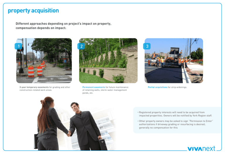
property acquisition Different approaches depending on project’s impact on property, compensation depends on impact: 1 3-year temporary easements for grading and other construction-related work areas. 2 Permanent easements for future maintenance of retaining walls, storm-water management ponds, etc. 3 Partial acquisitions for strip widenings. · Registered property interests will need to be acquired from impacted properities. Owners will be notified by York Region staff. · Other property owners may be asked to sign “Permission to Enter” authorizations if driveway grading or resurfacing is desired; generally no compensation for this boulevard: 4-lane road sidewalk at typical vivastation intersection continuity furnishing pedestrian zone zone zone information kiosk/ space for public art intersection crosswalk road bicycle lane street light continuity zone bench bicycle lane road property line pedestrian light tree in grate furnishing zone property line pedestrian zone property line tree in planter road bicycle lane continuity furnishing pedestrian zone zone zone community liaison role Community liaison specialist is working with property owners, tenants, local businesses, and the general public onsite to: · Provide timely construction updates · Be a single point of contact for questions and concerns · Provide onsite signage and other marketing support materials · Feature businesses on our website to help attract customers during construction · Coordinate meetings between project manager, owners and other parties to address individual property concerns/questions Our public communications and marketing team will be developing strategies to ensure that the public knows what is happening. preliminary cross section: 4-lane road 44.00 Right-of-way Property Line Property Line CORNELL 1:45 UNIONVILLE 1:45 Public Sidewalk intersection 0.30 2.00 Continuity Strip 2.50 0.60 0.50 Bicycle Lane 1.50 Through /Right-turn Lane Rumble Strip Left-turn Lane Through Lane Offset Transitway [Coloured Asphalt] Shelter/Platform 3.50 3.30 3.30 0.30 Bicycle Lane 2 Through Lanes 0.30 Clearance 0.70 3.50 3.50 4.00 3.30 3.50 0.50 0.60 1.50 Boulevard 5.90 40.00 Right-of-way mid-block 0.30 Continuity Strip 2.00 2.50 Boulevard 5.90 Public Sidewalk 2.50 Boulevard 5.90 Public Sidewalk Continuity Strip Bicycle 2 Through Lanes 0.60 0.50 Lane 1.50 Rumble Strip 0.30 3.50 3.30 Transitway [Coloured Asphalt] 3.50 Plantable Raised Median 4.00 Transitway [Coloured Asphalt] 3.50 Rumble Strip 0.30 3.30 2 Through Lanes 3.50 Bicycle Lane 0.50 0.60 1.50 Continuity Strip Public Sidewalk 2.50 Boulevard 5.90 2.00 0.30 2.00 0.30 yonge street: mulock drive to davis drive Match Line A Match Line A Scale: 1:500 yonge street rapidways timeline: mulock to davis drive 2010 Jan 2011 Feb Mar Apr May Jun Jul Aug Sep Oct Nov Dec Jan Feb Mar Apr May Property acquisition underway Preliminary design underway Final design/construction Projected completion date end-2013 engineering and construction timelines Project Description 2008 2009 2010 2011 2012 2013 2014 2015 2016 2017 Subways Spadina Subway Extension – Downsview station to York University Yonge Subway Extension – Finch station to Richmond Hill Centre Viva Operating Segments H2 Hwy 7 – Richmond Hill Centre to Pine Valley Drive H3 Hwy 7 – Richmond Hill Centre to Kennedy Road Y2 Yonge Street – Richmond Hill Centre to 19th Avenue Y3.2 Yonge Street – Mulock Drive to Davis Drive D1 Davis Drive – Yonge Street to Hwy 404 G1 Green Lane – Yonge Street to East Gwillimbury GO station H1 Hwy 7 – Pine Valley to Highway 50 H4 Hwy 7 – Kennedy to York Durham Line M1 Markham Centre to Don Mills station V1 Hwy 7 to Hwy 407/Jane subway station Y3.1 Yonge Street – 19th Avenue to Mulock Drive Y3.3 Yonge Street – Davis Drive to Green Lane Legend Concept Design / Preliminary Engineering / Land Acquisition Construction Updated January 2010 how are rapidways built? Guiding Principles ·Maintain access to business locations ·Minimize disruption ·Maintain 3 lanes of traffic ·Clean and safe work site July 2010 – February 2011 Complete Phase 1 : Concept Design Phase 2 : Preliminary Design Spring 2011 and forward Phase 3 : Construction ·Development of design elements ·Construction drawings ·Sequencing / scheduling of construction ·Utility relocation ·Road widening – one side at a time, including boulevards and planting ·Construct rapidways and stations down middle of road intersection: 4-lane road *Planned construction of bus rapid transit, includes dedicated and non-dedicated rapidway **Will connect to Bloor-Danforth subway Se ne ca Finch Avenue Downsview Station Finch Station Sheppard Avenue E St sna ee le s MARKHAM De nis on 14 th Highway 7 Don Mills Station Cornell Unionville Station Highway 407 Steeles Avenue TORONTO Finch Avenue Sheppard Avenue Map not to scale York Du Ho sp ita l e rham Lin Ga ls wo M rthy ain St .M ar kh am W oo te M nW ar k ay Bu ham rO S ak tou ffv ille y Road Highway 404 Sa va Mul ge oc k Ea gl e Highway 9 M cC ow an Kenned Wellington St. E. He Go nd lf L Wel Or er ink lin so gt char n s on dH eig ht s So ut hl ak e Hu ro nH ei Le sli ghts e Pa Lo rksi ng de fo M rd ain G Br ist ree nL ol an e East Gwillimbury GO Station Ke nn ed y To wn Ce C nt W ed re ar ar Bl de la vd . En n nd te rp ris e 404 Re Bl ga tta oom ing Avenue to n AUROR A Bayview Ki ng GO Transit Rail Lines treet Je ffe rs on treet Proposed Yonge Subway Extension Highway Leslie S 19 th -G am bl e Yonge S Terminals lie Street El B gin e M rna ill rd s Proposed Light Rail Transit** Le s M Cr ajo os rM by ac Ke nz ie Bathurs t Street Spadina Subway Extension M cN ico ll lls Road Richmond Hill Centre Ba 1 W nt 6t el ry hdr -S Ca ick co rr t v t Ba ille yv ie Ch w alm Va er lle s W yme Sou es d th Pa Le t Be e rk sli av e er Ea Cr ee st B k Al eav ls ta er C W te P re oo a ek db rk ine wa y VAU G H A N Hi ll n Mi VAU G H A N At kin so n treet y 400 RICHMOND HILL Do Steeles Avenue Cu S m Cl m teel ar Roy er es k al / L Lan /D Or o gs re ch ng taf wr ar br f y d idg e treet Highway 7 Du ffe rin Pr om en Ba ad th e ur st Ke el e Jane S Highwa 27 Future Rapidways* Yonge S Co m m er ce Pi ne Va lle y An sle yG ro W ve es to n Highway Funded Rapidways* Le ith Hi ll TORONTO Vaughan Metropolitan Centre Fi nc Sh hW ep pa es rd t W es t Highway 407 H Tr wy an 40 sit 7 St wa ee y le s W Yo es rk t Un ive rs ity Western Gateway Hi gh wa y4 27 Hi gh wa y2 7 M ar tin Gr ov Ki e pl ing Isl ing to n He le n Highway 50 vivaNext route map Green Lane Davis Drive Newmarket GO Station NEWMARKET Aurora Rd. WHITCHURCHSTOUFFVILLE Bloomington Rd. Stouffville Rd. MARKHAM Major MacKenzie Drive vivastation design elements roof extends up and over Viva vehicles to keep snow and rain off while embarking/disembarking roof and side panels made of reflective tinted glass for greater visibility and comfort arrival/departure screens provide real-time scheduling info plus up-to-the-minute time, weather, news, sports and market headlines extended platform length can accommodate multiple Viva vehicles, enhancing embarking/ disembarking efficiency full-time security surveillance and intercom for emergency assistance on platform raised platform provides level boarding of Viva vehicles, eliminating the need to climb steps or lift objects temperature and motion activated heaters in full wind enclosure provide warmth while motion-activated entry doors minimize heat loss tactile pavers along rapidway edge provide greater safety energy-efficient lighting throughout for greater safety and comfort gently sloping ramp provides easy wheelchair, motorized scooter and stroller access ample seating inside and out provides greater personal space and comfort flexible cash, pass and Presto fare machines
