Document 12417517
advertisement

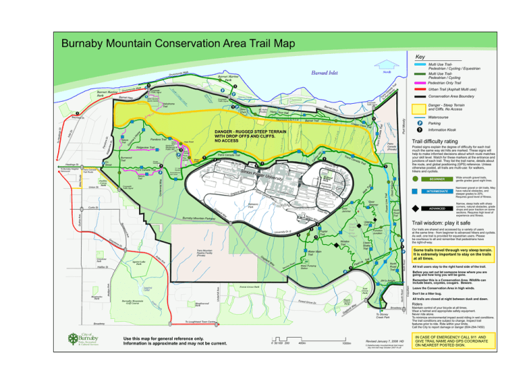
Burnaby Mountain Conservation Area Trail Map Key ? ai Tr da y a n od Ca Mo s t an or r T oP T P Simon Creek Bike Park ? Barn e BC Hydro (Private) Hang Your H at Cra b Cr eek Hi ac So uth Unive rsity Bus Loop mp us Rd . lar di Tow e W ay Ne l so n gh St . r Rd . Gear Jammer Way ? od University Dr. E . Ave ? Poplar Trail ? Dr . Squint Lake Park Trans Mountain Pipeline Facility (Private) nA ve Ga g . Halifax St. North Road Trail P Lower Snake Trail W ay Se eR rvic oad li Tra e Pip Water Pumping Station North Road Trail ? P Some trails travel through very steep terrain. It is extremely important to stay on the trails at all times. All trail users stay to the right hand side of the trail. Before you set out let someone know where you are going and how long you will be gone. Remember this is a Conservation Area. Wildlife can include bears, coyotes, cougars. Beware. Forest G rove Dr. Meadowood Park Maple Grove Park Ga Broadway rd gla ay iW Broadway To Stoney Creek Park To Loughheed Town Centre Parks, Recreation & Cultural Services Use this map for general reference only. Information is approximate and may not be current. 0 50 100 200 400m 1000m Leave the Conservation Area in high winds. Don’t be a litter bug. All trails are closed at night between dusk and dawn. Riders City of Burnab Coquitlam East Grove Park North Road Ea gl eC re ek Forest Grove Park Sto ney Cre ek Burnaby Mountain Golf Course Underhill Ave. Montecito Park Phillips Ave. Jim’s Jungle Squint Lake ADVANCED Narrow, steep trails with sharp corners, natural obstacles, grade drops and poor traction on some sections. Requires high level of experience and fitness. ? P il ne INTERMEDIATE Narrower gravel or dirt trails. May have natural obstacles, and steeper grades to 20%. Requires good level of fitness. Our trails are shared and accessed by a variety of users at the same time - from beginner to advanced hikers and cyclists. As well, one trail is provided for equestrian users. Please be courteous to all and remember that pedestrians have the right-of-way. Function Junction Water Main Trail lar di Wide smooth gravel trails, gentle grades good sight lines. Trail wisdom: play it safe Upper Cut Upper Snake Trail temp. Closed Nicoles Trail Ar de Greystone Park Hi Information Kiosk BEGINNER ? wo ne ? Gear Jammer rn Bu sto rsity Naheeno Park Burnaby Mountain Parkway Gr ey Ric Bolthoard Park n Univer sit H i g hl a n y ds Unive Ca Tra il ? Posted signs explain the degree of difficulty for each trail much the same way ski hills are marked. These signs will help to make informed decisions about which route matches your skill level. Watch for these markers at the entrance and junctions of each trail. They list the trail name, details about the route, and global positioning (GPS) reference. Unless otherwise posted, all trails are multi-use: for walkers, hikers and cyclists. North Road Ga g rdi Frase r a da Parking Dead Moped la Gag Way Un i v ersit y Univ Dr. E ersit y Cr. ? ? S i mo n Picnic/informal lawn areas Curtis St. Duthie Ave. r. W Can Power Line Trail Crosswalk/ Traffic Signal rsity D Tra ns ? P Trail difficulty rating Petro Canada (Private) il DuthieUnion Park k Trail Tr a Nature Trail r Cree s P Couga Watercourse ll Unive TC Trail Pavilion Trans Canada Trail ? M el Bike Route ? ? Trans Canada Trail Route Union St. Water Tower d. Private Residence ? Trans Canada Trail rd i Burnwood Trail Picnic Playground Ca P Rose Garden Centennial Way To Burnaby Heights/ Vancouver ? y. (Powerline ) Subma rines C reek Gn o Horizon's Restaurant & Public WC Rid g Hastings St. View Point Kamui Mintara Ridgeview Trail P On Street Nichols Creek Ho m e’s r. wD evie Pan d o ra Dr. Inle m e tD r. Pandora Trail Danger - Steep Terrain and Cliffs. No Access ek Cre DANGER - RUGGED STEEP TERRAIN WITH DROP OFFS AND CLIFFS. NO ACCESS Barnet Trail Conservation Area Boundary ille cev To Hastin g Transmission Line R.O.W. Urban Trail (Asphalt Multi use) Ali s St. Bayview Dr. t Hw na da T rai l ? P l Crosswalk/ Traffic Signal Trans Ca k ee Cr Crosswalk/ Traffic Signal Cou gar Cree k p m Ca Harry Jerome Sports Centre P ay -W ck ek lu Cre Thun T ’s sk Ka P Velodrome Trail Nature Trail North ? Crosswalk/ Traffic Signal Barnet Marine Park Barnet Hwy. Barnet Marine Park Tower R P a lk onds W Drumm Burrard Inlet Port Moody alk onds W Drumm Multi Use TrailPedestrian / Cycling / Equestrian Multi Use TrailPedestrian / Cycling Pedestrian Only Trail Revised January 7, 2008 HD C:Data/burnaby mountain\kiosk trail maps\ bby mnt trail map October 2007 N.cdr Maintain control of your bicycle at all times. Wear a helmet and appropriate safety equipment. Never ride alone. To minimize environmental impact avoid riding in wet conditions. The trail conditions are subject to change. Inspect trail features prior to ride. Ride within your limits. Call the City to report damage or danger (604-294-7450) IN CASE OF EMERGENCY CALL 911 AND GIVE TRAIL NAME AND GPS COORDINATE ON NEAREST POSTED SIGN.


