Project proposal form
advertisement
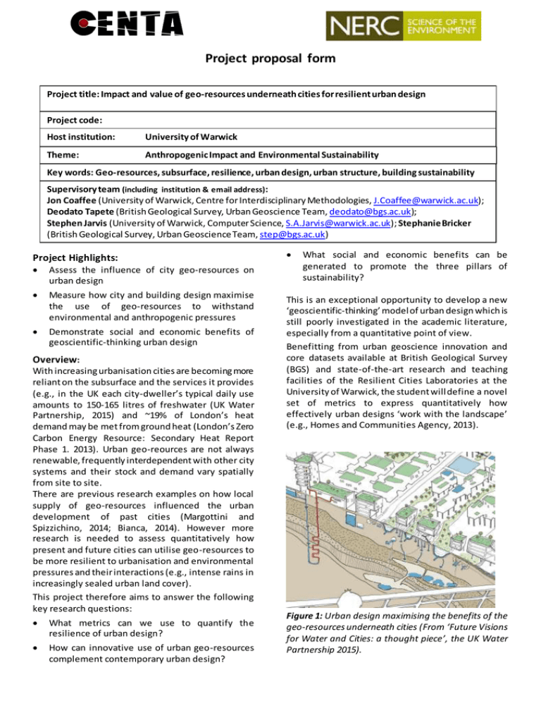
Project proposal form Project title: Impact and value of geo-resources underneath cities for resilient urban design Project code: Host institution: University of Warwick Theme: Anthropogenic Impact and Environmental Sustainability Key words: Geo-resources, subsurface, resilience, urban design, urban structure, building sustainability Supervisory team (including institution & email address): Jon Coaffee (University of Warwick, Centre for Interdisciplinary Methodologies, J.Coaffee@warwick.ac.uk); Deodato Tapete (British Geological Survey, Urban Geoscience Team, deodato@bgs.ac.uk); Stephen Jarvis (University of Warwick, Computer Science, S.A.Jarvis@warwick.ac.uk); Stephanie Bricker (British Geological Survey, Urban Geoscience Team, step@bgs.ac.uk) Project Highlights: Assess the influence of city geo-resources on urban design Measure how city and building design maximise the use of geo-resources to withstand environmental and anthropogenic pressures Demonstrate social and economic benefits of geoscientific-thinking urban design Overview: With increasing urbanisation cities are becoming more reliant on the subsurface and the services it provides (e.g., in the UK each city-dweller’s typical daily use amounts to 150-165 litres of freshwater (UK Water Partnership, 2015) and ~19% of London’s heat demand may be met from ground heat (London’s Zero Carbon Energy Resource: Secondary Heat Report Phase 1. 2013). Urban geo-reources are not always renewable, frequently interdependent with other city systems and their stock and demand vary spatially from site to site. There are previous research examples on how local supply of geo-resources influenced the urban development of past cities (Margottini and Spizzichino, 2014; Bianca, 2014). However more research is needed to assess quantitatively how present and future cities can utilise geo-resources to be more resilient to urbanisation and environmental pressures and their interactions (e.g., intense rains in increasingly sealed urban land cover). This project therefore aims to answer the following key research questions: What metrics can we use to quantify the resilience of urban design? How can innovative use of urban geo-resources complement contemporary urban design? What social and economic benefits can be generated to promote the three pillars of sustainability? This is an exceptional opportunity to develop a new ‘geoscientific-thinking’ model of urban design which is still poorly investigated in the academic literature, especially from a quantitative point of view. Benefitting from urban geoscience innovation and core datasets available at British Geological Survey (BGS) and state-of-the-art research and teaching facilities of the Resilient Cities Laboratories at the University of Warwick, the student will define a novel set of metrics to express quantitatively how effectively urban designs ‘work with the landscape’ (e.g., Homes and Communities Agency, 2013). Figure 1: Urban design maximising the benefits of the geo-resources underneath cities (From ‘Future Visions for Water and Cities: a thought piece’, the UK Water Partnership 2015). The research will be completed in the context of current future cities initiatives. The findings will be of immediate interest to practitioners and industry (e.g., firms of consulting designers, planners, engineers) and stakeholders (e.g., Future Cities Catapult, city councils), thereby leading to direct impact and opening a wide range of career perspectives to the student at the end of the PhD. Methodology: Partners and collaboration (including CASE): Specific objectives to achieve: O1. Identify city geo-resources influencing urban design. This will be done accounting for above- and below-ground components of city systems, and green and blue infrastructure as integral parts of ecofriendly and sustainable ways of designing cities. O2. Quantify the resilience performance of current practices of designing different cities architectures and buildings in relation to city geo-resource usage. The student will have full access to BGS core datasets (e.g., GeoSure, SuDS, Mines and Quarries). The geographical focus will be the UK, but the research method might extend to selected case studies overseas. The student will carry out part of their research at BGS in Keyworth, Nottingham (total period of 3-4 months). The placement will involve working directly with BGS Urban Geoscience Team, accessing and analysing nationwide geological and environmental datasets, geohazard products and digital datasets relevant to the research project. This provides an exceptional opportunity to build a professional and academic profile capable to connect specialist geological expertise and urban design skills to the broader decision-making context of a complex project and geoscientific data provision. O3. Generate a geo-resource systems analysis tool highlighting strengths, weaknesses, opportunities, possible threats and proposed way forwards to resilient urban design. This analysis will specifically include an assessment of the physical, economic and social implications for urban communities, shaping new and existing spaces through planning, design and management, and redesign to mitigate for potential threats. Data analytic and statistical foundations, including introduction to core methods and tools. The student will strengthen in the skills of ‘Sustainability Science and Planning’, ‘Data Management’, ‘Modelling’ and ‘Translating Research into Practice’ that NERC (2012) identified as ‘most wanted’ and ‘cross-disciplinary’ in the environment sector. This project will benefit from existing BGS/Warwick collaboration, support from the Warwick Institute for the Science of Cities and Warwick’s Resilient Cities Laboratory. Warwick is also the only European partner in the international Center for Urban Science and Progress (CUSP) based in New York, which provides an international platform for the dissemination and exploitation of this research. As the PhD progresses, the supervisory team will pursue options for a placement with an urban planning/design company in Year 2 providing the student with a bespoke development opportunity. Training and skills: CENTA students are required to complete 45 days training throughout their PhD including a 10 day placement. In the first year, students will be trained as a single cohort on environmental science, research methods and core skills. Throughout the PhD, training will progress from core skills sets to master classes specific to the student's projects and themes. Specifically for this project, the PhD student will gain state-of-the-art skills of urban resilience and how to integrate geological approaches into urban analysis, modelling and planning. Training will be provided in: Urban geological environments: assessment and investigation; GIS and geospatial analysis; 3D geological modelling and high-resolution 3D visualisation of spatial data to interrogate wide range of environmental datasets and relate subsurface ground investigations to the aboveground; Possible timeline: Year 1: The student will undertake a comprehensive literature review of contemporary theory and practice of sustainable urbanism harnessing the intrinsic natural resources of the site. The student will collate data and analyse case studies for comparative assessment. The expected research output is the publication of a white paper. Year 2: Building upon the findings of this review, the student will focus on definition and implementation of metrics to assess quantitatively the role played by each subsurface geo-resource and their combination on the resilient performance of most representative forms of cities and buildings. The analysis will be across the UK and also include an assessment of the value of the geoscientific information and ground investigation as integral part of the design process. The results will be presented in a scientific peerreviewed publication. Year 3: The student will develop a ‘geoscientificthinking model’ as a new paradigm of urban design, associated with a systems analayis tool of the challenges and opportunities towards resilient design solutions. Time will be dedicated to dissertation preparation, alongside dissemination at international conferences and stakeholder meetings as part of the pathways to impact of this research. Further reading: Bianca, S. (2014) Morphology as the Study of City Form and Layering. In: Reconnecting the City (eds F. Bandarin and R. van Oers), John Wiley & Sons, Ltd, Oxford, UK, pp. 85-111. Bricker, S., Reeves, H., Campbell, S.D.G., Price, S. The ground beneath cities: where should future development occur? A Thought Piece by British Geological Survey. https://www.gov.uk/government/uploads/system/ uploads/attachment_data/file/461947/futurecities-ground-beneath.pdf Coaffee, J. (2009) Terrorism, Risk and the Global City – towards urban resilience. Ashgate, Farnham. Coaffee, J. (2013) Rescaling and Responsibilising the Politics of Urban Resilience: From National Security to Local Place-Making, Politics doi: 10.1111/14679256.12011 European Commission (2002) Consultative Guidelines for Sustainable Urban Development Co-operation. Towards Sustainable Urban Development: a Strategic Approach. 224 pp. http://www.ucl.ac.uk/dpuprojects/21st_Century/resources/institutional/Pdf %20files/Tow_Sust_Urb_EU_Guidelines.pdf Homes and Communities Agency (2000, 2013) Urban Design Compendium. (ed L. D. Yeang), 121 pp. http://udc.homesandcommunities.co.uk/urbandesign-compendium?page_id=5542&page=200 London’s Zero Carbon Energy Resource: Secondary Heat Report Phase 1 https://www.london.gov.uk/sites/default/files/130 220%20031250%20GLA%20Low%20Carbon%20He at%20Study%20Report%20Phase%201%20%20Rev01_0.pdf Margottini, C. and Spizzichino, D. (2014) How Geology Shapes Human Settlements. In: Reconnecting the City (eds F. Bandarin and R. van Oers), John Wiley & Sons, Ltd, Oxford, UK, pp. 47-84. NERC (2012) Most Wanted II Postgraduate and Professional Skills Needs in the Environment Sector. LWEC Report 2012. Resilience in Ecology and Urban Design. Linking Theory and Practice for Sustainable Cities. Pickett, S.T.A. et al. (eds), Springer, Netherlands, 2013, 499 pp. doi: 10.1007/978-94-007-5341-9 The UK Water Partnership (2015) Future Visions for Water and Cities. A Thought Piece. 31 pp. https://www.gov.uk/government/uploads/system/ uploads/attachment_data/file/439301/gs-15-27future-visions-for-water-and-cities-thoughtpiece.pdf Further details: For information about this PhD project, please contact the supervisory team: Jon Coaffee (J.Coaffee@warwick.ac.uk) Stephen Jarvis (S.A.Jarvis@warwick.ac.uk) Deodato Tapete (deodato@bgs.ac.uk) Stephanie Bricker (step@bgs.ac.uk) More information about the Warwick Institute for the Science of Cities can be found at: http://www.wisc.warwick.ac.uk The Warwick Resilient Cities Laboratory can be found via the following link: http://www2.warwick.ac.uk/fac/soc/rcl/ The international Center for Urban Science and Progress (CUSP) can be found at http://cusp.nyu.edu For information about BGS Urban Geoscience Team and ongoing urban science research please visit: http://www.bgs.ac.uk/research/engineeringGeology/ urbanGeoscience/home.html http://britgeopeople.blogspot.co.uk/2015/08/futurevisions-for-water-and-citiesby.html Applicants with either environmental science or urban design background are encouraged to apply.
