Document 11943930
advertisement
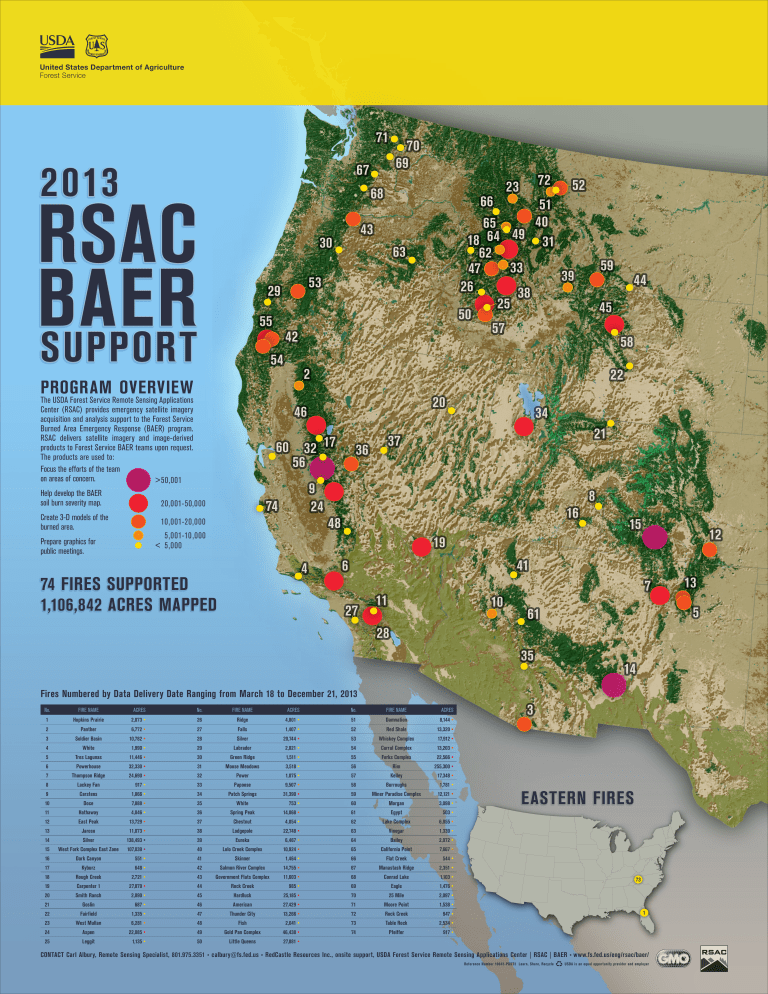
United States Department of Agriculture Forest Service 71 2013 70 69 67 RSAC BAER SUPPORT 29 55 52 51 40 31 59 39 58 22 20 17 60 32 56 9 24 74 5,001-10 ,000 < 5,000 44 45 2 10,001-20,000 Prepare graphics for public meetings. 63 46 20,001-50,000 Create 3-D models of the burned area. 43 42 54 The USDA Forest Service Remote Sensing Applications Center (RSAC) provides emergency satellite imagery acquisition and analysis support to the Forest Service Burned Area Emergency Response (BAER) program. RSAC delivers satellite imagery and image-derived products to Forest Service BAER teams upon request. The products are used to: Focus the efforts of the team on areas of concern. > 50,001 66 65 49 64 18 62 33 47 26 38 25 50 57 53 PROGRAM OVERVIEW Help develop the BAER soil burn severity map. 23 68 30 72 34 21 37 36 16 48 8 15 12 19 4 74 FIRES SUPPORTED 1,106,842 ACRES MAPPED 41 6 27 11 10 7 5 61 28 35 14 Fires Numbered by Data Delivery Date Ranging from March 18 to December 21, 2013 No. FIRE NAME ACRES No. FIRE NAME ACRES No. FIRE NAME ACRES 1 Hopkins Prairie 2,073 • 26 Ridge 4,801 • 51 Damnation 8,144 • 2 Panther 6,772 • 27 Falls 1,407 • 52 Red Shale 13,320 • 3 Soldier Basin 10,782 • 28 Silver 20,744 • 53 Whiskey Complex 17,912 • 4 White 1,990 • 29 Labrador 2,021 • 54 Corral Complex 13,203 • 5 Tres Lagunas 11,446 • 30 Green Ridge 1,511 • 55 Forks Complex 22,566 • 6 Powerhouse 32,330 • 31 Moose Meadows 3,518 • 56 Rim 255,300 • 7 Thompson Ridge 24,690 • 32 Power 1,075 • 57 Kelley 17,348 • 8 Lackey Fan 917 • 33 Papoose 9,507 • 58 Burroughs 1,781 • 9 Carstens 1,866 • 34 Patch Springs 31,390 • 59 Miner Paradise Complex 12,121 • 10 Doce 7,888 • 35 White 753 • 60 Morgan 3,098 • 11 Hathaway 4,046 • 36 Spring Peak 14,068 • 61 Egypt 12 East Peak 13,729 • 37 Chestnut 4,054 • 62 Lake Complex 6,855 • 13 Jaroso 11,073 • 38 Lodgepole 22,748 • 63 Vinegar 1,339 • 14 Silver 138,493 • 39 Eureka 6,467 • 64 Bailey 2,072 • 15 West Fork Complex East Zone 107,039 • 40 Lolo Creek Complex 10,924 • 65 California Point 7,667 • 16 Dark Canyon 551 • 41 Skinner 1,464 • 66 Flat Creek 544 • 17 Kyburz 648 • 42 Salmon River Complex 14,755 • 67 Manastash Ridge 2,351 • 18 Rough Creek 2,721 • 43 Government Flats Complex 11,603 • 68 Conrad Lake 1,103 • 19 Carpenter 1 27,879 • 44 Rock Creek 985 • 69 Eagle 1,476 • 20 Smith Ranch 2,890 • 45 Hardluck 25,185 • 70 25 Mile 2,097 • 21 Goslin 687 • 46 American 27,429 • 71 Moore Point 1,538 • 22 Fairfield 1,335 • 47 Thunder City 13,266 • 72 Rock Creek 947 • 23 West Mullan 6,281 • 48 Fish 2,041 • 73 Table Rock 2,534 • 24 Aspen 22,085 • 49 Gold Pan Complex 46,438 • 74 Pfeiffer 25 Leggit 1,135 • 50 Little Queens 27,881 • 3 EASTERN FIRES 503 • 73 1 917 • CONTACT Carl Albury, Remote Sensing Specialist, 801.975.3351 • calbury@fs.fed.us • RedCastle Resources Inc., onsite support, USDA Forest Service Remote Sensing Applications Center | RSAC | BAER • www.fs.fed.us/eng/rsac/baer/ Reference Number 10043-POST3 Learn, Share, Recycle 13 USDA is an equal opportunity provider and employer
