The Wallowas
advertisement

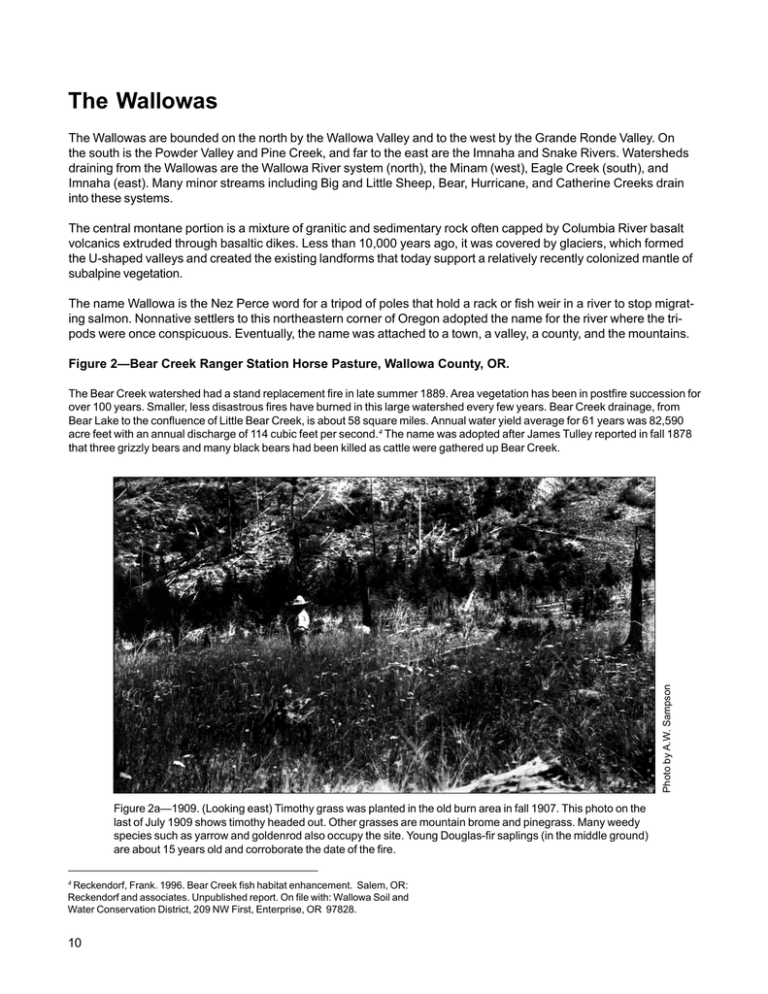
The Wallowas The Wallowas are bounded on the north by the Wallowa Valley and to the west by the Grande Ronde Valley. On the south is the Powder Valley and Pine Creek, and far to the east are the Imnaha and Snake Rivers. Watersheds draining from the Wallowas are the Wallowa River system (north), the Minam (west), Eagle Creek (south), and Imnaha (east). Many minor streams including Big and Little Sheep, Bear, Hurricane, and Catherine Creeks drain into these systems. The central montane portion is a mixture of granitic and sedimentary rock often capped by Columbia River basalt volcanics extruded through basaltic dikes. Less than 10,000 years ago, it was covered by glaciers, which formed the U-shaped valleys and created the existing landforms that today support a relatively recently colonized mantle of subalpine vegetation. The name Wallowa is the Nez Perce word for a tripod of poles that hold a rack or fish weir in a river to stop migrating salmon. Nonnative settlers to this northeastern corner of Oregon adopted the name for the river where the tripods were once conspicuous. Eventually, the name was attached to a town, a valley, a county, and the mountains. Figure 2—Bear Creek Ranger Station Horse Pasture, Wallowa County, OR. Photo by A.W. Sampson The Bear Creek watershed had a stand replacement fire in late summer 1889. Area vegetation has been in postfire succession for over 100 years. Smaller, less disastrous fires have burned in this large watershed every few years. Bear Creek drainage, from Bear Lake to the confluence of Little Bear Creek, is about 58 square miles. Annual water yield average for 61 years was 82,590 acre feet with an annual discharge of 114 cubic feet per second.4 The name was adopted after James Tulley reported in fall 1878 that three grizzly bears and many black bears had been killed as cattle were gathered up Bear Creek. Figure 2a—1909. (Looking east) Timothy grass was planted in the old burn area in fall 1907. This photo on the last of July 1909 shows timothy headed out. Other grasses are mountain brome and pinegrass. Many weedy species such as yarrow and goldenrod also occupy the site. Young Douglas-fir saplings (in the middle ground) are about 15 years old and corroborate the date of the fire. 4 Reckendorf, Frank. 1996. Bear Creek fish habitat enhancement. Salem, OR: Reckendorf and associates. Unpublished report. On file with: Wallowa Soil and Water Conservation District, 209 NW First, Enterprise, OR 97828. 10 Figure 2b—1998. The position of the camera point of this retake is exact. This site was originally a mature grand (white) fir-twinflower-pinegrass community before the fire about 110 years ago. It has reverted to an early phase of that community. The understory also contains elk sedge and western fescue. There is no trace of the introduced timothy. This 30-acre pasture once used for horses has provided forage for wildlife only since about 1950. 11 Figure 3—Dobbin Creek Basin, Wallowa County, OR. Photo by W.L. Dutton Dobbin Creek Basin in the northwest Wallowas was a part of the Standley Sheep Range. This range, claimed by John H. Standley in about 1885, was later used by Jay H. Dobbin. Before the National Forest was created in 1906, a band of about 1,200 head of adult wether sheep would graze a month or more in this basin. By the late 1960s, smaller bands of 850 to 900 ewes and lambs would stay 10 days grazing over the equivalent range. Today, largely for economic reasons, no sheep graze in the Wallowas. Figure 3a—Around 1924. (Looking north) Large patches of snags, remnants of former fires, are seen across the landscape. A fire watch was once posted in a tree house in the top of a tall whitebark pine snag some 15 to 20 yards from this camera point, although at this early date, fire suppression in the high mountains was not very effective. A telephone line to the ranger station in Wallowa had only recently been installed. 12 Photo by W.B. Hall Figure 3b—1974. A striking encroachment and closure of the forest can be discerned over the past 50 years. Subalpine fir has invaded much of the grassland in the lower basin. This is also noticeable on the bald ridge across the basin (right). Figure 3c—1997. The Fox Point Fire of 1996 burned about two-thirds of the visible forest, thus placing it in about the same condition it was about the turn of the 20th century. Cover on the steep slope where the sheep were in 1924 appears to be somewhat more broken with open spaces between plant clumps. Today, pokeweed fleeceflower is prevalent on the slope. This camera point was moved about 35 feet east to avoid a wall of trees that had grown up and obliterated the original view. 13 Photo by A.W. Sampson Figure 3d—1908. (Looking south) On July 25, 1908, large snowdrifts still persist in pockets and on north-facing slopes of the Dobbin Creek watershed. Many downed snags can be seen beyond the left midground snow fields, giving evidence of earlier fire. Judging from the advanced stage of regenerated subalpine fir, the fire would probably have occurred during the mid-1800s. Figure 3e—1998. This photo was taken in late August but at the same location at the foot of the original tree house lookout. The first lookout was in a large whitebark pine snag that still stands today (fig. 3f). The subsequent tower was on the point of the ridge (upper right). It was dismantled in 1955. The background of the repeat photo shows heavy subalpine fir crown spread and considerable basal expansion. The two larger subalpine fir trees in the photo center appear to have improved in health and must be nearly 200 years old. 14 Figure 3f—1998. Tree house lookout. 15


