Document 11842213
advertisement
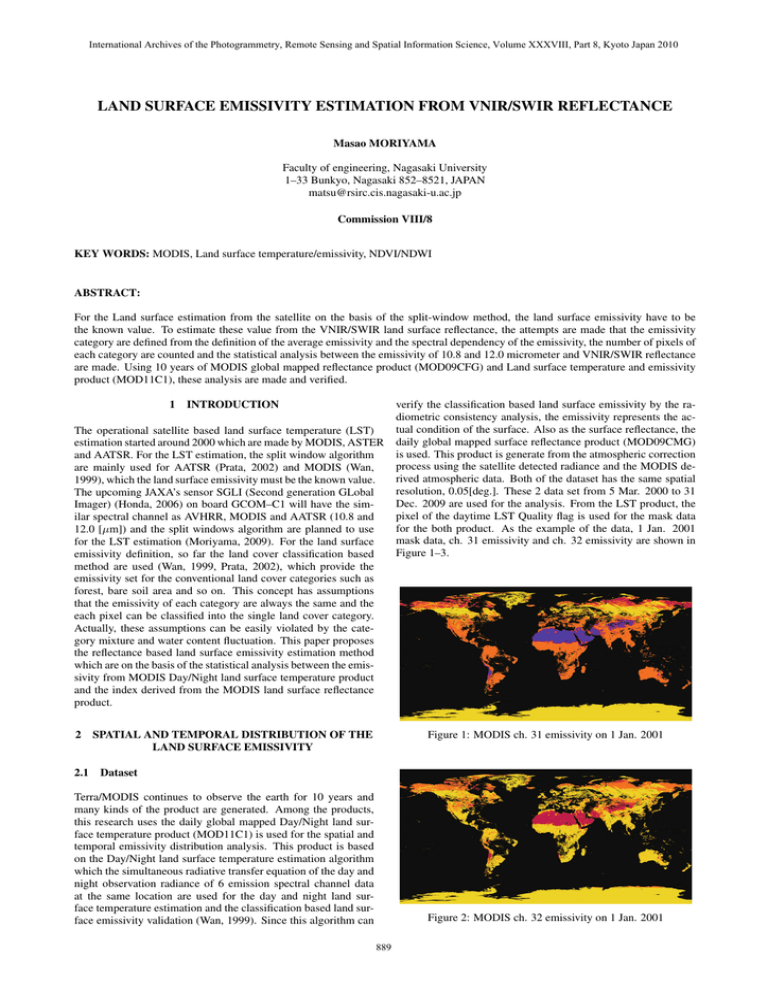
International Archives of the Photogrammetry, Remote Sensing and Spatial Information Science, Volume XXXVIII, Part 8, Kyoto Japan 2010 LAND SURFACE EMISSIVITY ESTIMATION FROM VNIR/SWIR REFLECTANCE Masao MORIYAMA Faculty of engineering, Nagasaki University 1–33 Bunkyo, Nagasaki 852–8521, JAPAN matsu@rsirc.cis.nagasaki-u.ac.jp Commission VIII/8 KEY WORDS: MODIS, Land surface temperature/emissivity, NDVI/NDWI ABSTRACT: For the Land surface estimation from the satellite on the basis of the split-window method, the land surface emissivity have to be the known value. To estimate these value from the VNIR/SWIR land surface reflectance, the attempts are made that the emissivity category are defined from the definition of the average emissivity and the spectral dependency of the emissivity, the number of pixels of each category are counted and the statistical analysis between the emissivity of 10.8 and 12.0 micrometer and VNIR/SWIR reflectance are made. Using 10 years of MODIS global mapped reflectance product (MOD09CFG) and Land surface temperature and emissivity product (MOD11C1), these analysis are made and verified. 1 INTRODUCTION The operational satellite based land surface temperature (LST) estimation started around 2000 which are made by MODIS, ASTER and AATSR. For the LST estimation, the split window algorithm are mainly used for AATSR (Prata, 2002) and MODIS (Wan, 1999), which the land surface emissivity must be the known value. The upcoming JAXA’s sensor SGLI (Second generation GLobal Imager) (Honda, 2006) on board GCOM–C1 will have the similar spectral channel as AVHRR, MODIS and AATSR (10.8 and 12.0 [μm]) and the split windows algorithm are planned to use for the LST estimation (Moriyama, 2009). For the land surface emissivity definition, so far the land cover classification based method are used (Wan, 1999, Prata, 2002), which provide the emissivity set for the conventional land cover categories such as forest, bare soil area and so on. This concept has assumptions that the emissivity of each category are always the same and the each pixel can be classified into the single land cover category. Actually, these assumptions can be easily violated by the category mixture and water content fluctuation. This paper proposes the reflectance based land surface emissivity estimation method which are on the basis of the statistical analysis between the emissivity from MODIS Day/Night land surface temperature product and the index derived from the MODIS land surface reflectance product. 2 SPATIAL AND TEMPORAL DISTRIBUTION OF THE LAND SURFACE EMISSIVITY verify the classification based land surface emissivity by the radiometric consistency analysis, the emissivity represents the actual condition of the surface. Also as the surface reflectance, the daily global mapped surface reflectance product (MOD09CMG) is used. This product is generate from the atmospheric correction process using the satellite detected radiance and the MODIS derived atmospheric data. Both of the dataset has the same spatial resolution, 0.05[deg.]. These 2 data set from 5 Mar. 2000 to 31 Dec. 2009 are used for the analysis. From the LST product, the pixel of the daytime LST Quality flag is used for the mask data for the both product. As the example of the data, 1 Jan. 2001 mask data, ch. 31 emissivity and ch. 32 emissivity are shown in Figure 1–3. Figure 1: MODIS ch. 31 emissivity on 1 Jan. 2001 2.1 Dataset Terra/MODIS continues to observe the earth for 10 years and many kinds of the product are generated. Among the products, this research uses the daily global mapped Day/Night land surface temperature product (MOD11C1) is used for the spatial and temporal emissivity distribution analysis. This product is based on the Day/Night land surface temperature estimation algorithm which the simultaneous radiative transfer equation of the day and night observation radiance of 6 emission spectral channel data at the same location are used for the day and night land surface temperature estimation and the classification based land surface emissivity validation (Wan, 1999). Since this algorithm can Figure 2: MODIS ch. 32 emissivity on 1 Jan. 2001 889 International Archives of the Photogrammetry, Remote Sensing and Spatial Information Science, Volume XXXVIII, Part 8, Kyoto Japan 2010 1 # of pixels Relative accumlated frequency 1e+09 1e+08 0.8 # of pixels 1e+07 1e+06 0.6 100000 10000 0.4 1000 100 Figure 3: The mask image on 1 Jan. 2001 0.2 Relative accumlated frequency 1e+10 10 1 0 20 40 60 80 100 120 0 140 Emissivity category 2.2 Emissivity category Figure 5: Total pixel of the emissivity category (All category) 1e+10 1 # of pixels Relative accumlated frequency 1e+09 1e+08 0.8 ε̄ = ε 1 + ε2 2 Δε = # of pixels 1e+07 (1) ε1 − ε2 2 1e+06 0.6 100000 10000 0.4 1000 (2) 100 0.2 Relative accumlated frequency The land surface emissivity widely varies with the land cover and the wavelength. For the rough estimation of the emissivity variation, the emissivity category is defined. To separate the spectral dependency and the magnitude of the emissivity, the following two parameters, the average emissivity ε̄ and the spectral dependency parameter a are defined as Eq. (1 – 3), 10 a= Δε 1 − ε̄ 1 (3) 0.95 66 55 45 36 28 21 15 10 6 3 1 0 79 67 56 46 37 29 22 16 11 7 4 2 122 107 93 80 68 57 47 38 30 23 17 12 8 123 108 94 81 69 58 48 39 31 24 18 13 9 19 14 32 25 82 70 59 49 40 83 71 60 50 41 33 26 20 61 51 42 34 27 84 72 127 112 98 85 73 62 52 43 35 128 113 99 86 74 63 53 44 129 114 100 87 75 64 54 130 115 101 88 76 65 131 116 102 89 77 126 111 97 0.85 0.8 20 1e+07 1e+06 100000 132 117 103 90 0.75 133 118 104 134 119 0.7 0.65 0.65 15 The variation of the pixel number of each category are shown in Figure 7 and 8. It is clarified that the 0th. and 1st. category varied in the inverse phase, the 2nd. and 4th. category varied in the similar phase and the 7th. category kept constant. Also it is clarified that this 5 emissivity categories are significant. 5 125 110 96 124 109 95 0.9 10 Figure 6: Total pixel of the emissivity category (0–20th. category) Number of pixels MODIS ch. 32 emissivity 78 121 106 92 120 105 91 5 Emissivity category where ε1 and ε2 are emissivity at MODIS ch. 31 (11[μm]) and ch. 32 (12[μm]) respectively. To make the 0.02 interval grid on ε1 – ε2 plane, ε̄ and a are divided and the emissivity category is defined as Figure 4. 1 0 0 135 0.7 0.75 0.8 0.85 0.9 0.95 1 10000 1000 100 MODIS ch. 31 emissivity Figure 4: The emissivity category 10 1 2000 2001 2002 2003 2004 2005 2006 2007 2008 2009 2010 2.3 Temporal and spatial distribution of the emissivity category Year 0 From 10 years daily dataset, the total numbers of pixel of each emissivity category are counted. The result of all category is shown in Figure 5 and the result of 0 – 20th. category is shown in Figure 6. The green dashed line in the both figure show the relative cumulative frequency, up to 7th. emissivity category, almost all land cover are included. 1 2 3 4 5 6 Figure 7: Daily variation of the pixel number of the emissivity category (0–6th. category) 890 International Archives of the Photogrammetry, Remote Sensing and Spatial Information Science, Volume XXXVIII, Part 8, Kyoto Japan 2010 1e+06 Number of pixels 100000 10000 1000 100 10 1 2000 2001 2002 2003 2004 2005 2006 2007 2008 2009 2010 Year 7 8 9 10 11 12 Figure 8: Daily variation of the pixel number of the emissivity category (7–12th. category) To identify the emissivity categories, the average and standard deviation of LST of each emissivity category are computed, The results are shown in Figure 9 and 10. Al so the 0 - 2nd. categories and 3rd, 4th. and 7th. categories of 1 Jan. 2001 and 1 July 2001 are shown in Figure 11 and 12. Figure 11: Emissivity category map of 1 Jan. 2001 (Upper: Red: 2, Green: 1, Blue: 0, Lower: Red: 7, Green: 4, Blue: 3) 330 320 Average LST [K]’ 310 300 290 280 270 260 250 240 0 20 40 60 80 100 120 140 Emissivity category Figure 9: The average and standard deviation of LST at each category (All category) 330 320 Average LST [K]’ 310 Figure 12: Emissivity category map of 1 July 2001 (Upper: Red: 2, Green: 1, Blue: 0, Lower: Red: 7, Green: 4, Blue: 3) 300 290 280 From the above analysis, it is clarified that the 0th. emissivity category corresponds to the snow/ice area and 1st. emissivity category corresponds to the vegetation. Also it is clarified the most significant emissivity change is the alternation of the 0th. and 1st emissivity category in the annual land cover change. 270 260 250 240 0 5 10 15 20 2.4 Land surface estimation from the VNIR/SWIR reflectance Emissivity category The surface emissivity is affected by not only the land cover also the water content (J. W. Salisbery, 1992). To identify these condition, many kinds of indexes derived from the satellite data are proposed. Among these, this research use NDVI (Normalized Differential Vegetation Index) (de Griend and Owe, 1993) and Figure 10: The average and standard deviation of LST at each category (0 – 20th. category) 891 International Archives of the Photogrammetry, Remote Sensing and Spatial Information Science, Volume XXXVIII, Part 8, Kyoto Japan 2010 NDWI (Normalized Differential Water Index) (Gao, 1996) are used. This study estimates the average emissivity ε̄ (cf. Eq. (1)) and the spectral dependency parameter a (cf. Eq. (3)) using NDVI and NDWI derived from MOD09CMG product as follows, N DV I = ρ 2 − ρ1 ρ2 + ρ1 (4) N DW I = ρ2 − ρ 6 ρ2 + ρ6 (5) where ρ means the surface reflectance and subscript shows the MODIS spectral channel. At first the degree of variation of ε̄ and a are computed from the 10 years dataset. The standard deviation of these variables are shown in Figure 13. Figure 14: Correlation coefficient between a and NDVI (Upper), NDWI (Lower) 3 CONCLUSIONS The previous discussions lead the following results. The land surface emissivity largely varies in the high latitude area because of the alternation of ice/snow and vegetation. To estimated the emissivity, NDWI is effective, especially the wavelength dependency of the emissivity estimation. ACKNOWLEDGMENTS This research was supported by JAXA/GCOM–C project. REFERENCES de Griend, A. A. V. and Owe, M., 1993. On the relationship between thermal emissivity and the normalized difference vegatation index for the natural surface. International Journal of Remote Sensing 44(8), pp. 1119–1131. Figure 13: Standard deviation of ε̄ (Upper) and a (Lower) As the previous the emissivity category research, ε̄ does not so much varied, but a varied especially in the high latitude area. This is because the category 0 (ice/snow) and 1 (vegetation) is the dominant category, the alternation of these 2 categories is the significant emissivity change and these 2 categories have similar emissivity. So that in this research, a is defined as the estimated variable. Gao, B. C., 1996. NDWI – A normalized difference water index for remote sensing of vegetation liquid water from space. Remote Sensing of Environment 58(2), pp. 257–266. Honda, Y., 2006. The possibility of SGLI/GCOM-C for global environment change monitoring. In: Proc. SPIE. J. W. Salisbery, D. M. D., 1992. Emissivity of terrestrial materials in the 8 – 14 μm atmospheric window. Remote Sensing of Environment 42(2), pp. 83–106. To estimate a, the pixel–wise estimation is used, this means the a estimation formula is made at each pixel. For the definition of the independent variable of the estimation, the correlation coefficient between a and NDVI, NDWI are computed, the results are shown in Figure 14. The correlation between a and NDWI is high than that of NDVI, especially the high latitude area. This shows that the most significant emissivity change in the high latitude area can estimate the NDWI. Moriyama, M., 2009. Investigation of the split window algorithm for the land surface temperature estimation. In: Proc. Fall Conf. of Japanese Photogrammeetry and Remote Sensing, pp. 65–68. Prata, F., 2002. Land surface temperature measurement from space: AATSR Algorithm Theoretical Basis Document. Technical report, CSIRO. Wan, Z., 1999. MODIS Land–Surface Temperature Algorithm Theoretical Basis Document. NAS5–31370, NASA. 892
