REQUIREMENTS FOR NEW AIRBORNE DIGITAL SENSORS
advertisement
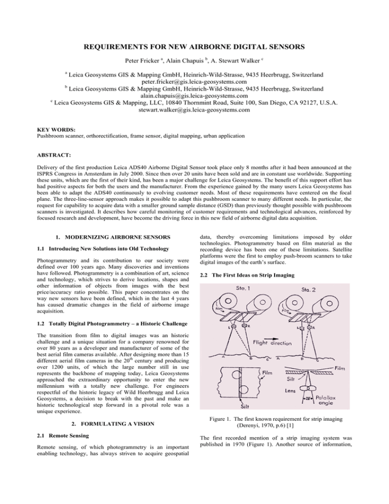
REQUIREMENTS FOR NEW AIRBORNE DIGITAL SENSORS Peter Fricker a, Alain Chapuis b, A. Stewart Walker c a Leica Geosystems GIS & Mapping GmbH, Heinrich-Wild-Strasse, 9435 Heerbrugg, Switzerland peter.fricker@gis.leica-geosystems.com b Leica Geosystems GIS & Mapping GmbH, Heinrich-Wild-Strasse, 9435 Heerbrugg, Switzerland alain.chapuis@gis.leica-geosystems.com c Leica Geosystems GIS & Mapping, LLC, 10840 Thornmint Road, Suite 100, San Diego, CA 92127, U.S.A. stewart.walker@gis.leica-geosystems.com KEY WORDS: Pushbroom scanner, orthorectification, frame sensor, digital mapping, urban application ABSTRACT: Delivery of the first production Leica ADS40 Airborne Digital Sensor took place only 8 months after it had been announced at the ISPRS Congress in Amsterdam in July 2000. Since then over 20 units have been sold and are in constant use worldwide. Supporting these units, which are the first of their kind, has been a major challenge for Leica Geosystems. The benefit of this support effort has had positive aspects for both the users and the manufacturer. From the experience gained by the many users Leica Geosystems has been able to adapt the ADS40 continuously to evolving customer needs. Most of these requirements have centered on the focal plane. The three-line-sensor approach makes it possible to adapt this pushbroom scanner to many different needs. In particular, the request for capability to acquire data with a smaller ground sample distance (GSD) than previously thought possible with pushbroom scanners is investigated. It describes how careful monitoring of customer requirements and technological advances, reinforced by focused research and development, have become the driving force in this new field of airborne digital data acquisition. 1. MODERNIZING AIRBORNE SENSORS 1.1 Introducing New Solutions into Old Technology Photogrammetry and its contribution to our society were defined over 100 years ago. Many discoveries and inventions have followed. Photogrammetry is a combination of art, science and technology, which strives to derive locations, shapes and other information of objects from images with the best price/accuracy ratio possible. This paper concentrates on the way new sensors have been defined, which in the last 4 years has caused dramatic changes in the field of airborne image acquisition. data, thereby overcoming limitations imposed by older technologies. Photogrammetry based on film material as the recording device has been one of these limitations. Satellite platforms were the first to employ push-broom scanners to take digital images of the earth’s surface. 2.2 The First Ideas on Strip Imaging 1.2 Totally Digital Photogrammetry – a Historic Challenge The transition from film to digital images was an historic challenge and a unique situation for a company renowned for over 80 years as a developer and manufacturer of some of the best aerial film cameras available. After designing more than 15 different aerial film cameras in the 20th century and producing over 1200 units, of which the large number still in use represents the backbone of mapping today, Leica Geosystems approached the extraordinary opportunity to enter the new millennium with a totally new challenge. For engineers respectful of the historic legacy of Wild Heerbrugg and Leica Geosystems, a decision to break with the past and make an historic technological step forward in a pivotal role was a unique experience. 2. FORMULATING A VISION 2.1 Remote Sensing Remote sensing, of which photogrammetry is an important enabling technology, has always striven to acquire geospatial Figure 1. The first known requirement for strip imaging (Derenyi, 1970, p.6) [1] The first recorded mention of a strip imaging system was published in 1970 (Figure 1). Another source of information, which realized the three-line push broom principle is the patent issued to O. Hofmann in Germany in 1979. The culmination of all ideas concerning three-line pushbroom technology occurred, when Leica Geosystems and DLR (German Aerospace Centre) signed a cooperation agreement in 1996 to design and produce the first commercial airborne large format digital camera worthy of that name. This resulted in the launch of the ADS40. 3.2 Constraints in the Airborne Environment A major challenge was to make this new sensor a reliable tool in the very demanding airborne environment. For example one of the most critical issues was the adaptation to the atmospheric requirements. After approximately 20 years of observing the market and the developments in different technologies, such as CCD sensors, storage media, GPS, inertial measurement systems and computing technology, Leica Geosystems was finally in a position in 1994 to start investigating seriously how to manufacture a series production digital airborne sensor. In 1998 LH Systems (which in 2001 was reintegrated into Leica Geosystems) announced the ADS40 and in the year 2000 it was presented at the ISPRS Congress in Amsterdam. The innovation process and the formulation of requirements, which is the theme of this paper, essentially took place between 1996 and 1998. 3. COLLECTING IDEAS AND REQUIREMENTS 3.1 Market Research to Establish User Requirements Market research consisted mainly of: • Observing technological advances and developments in similar markets, such as satellite platforms equipped with remote sensing equipment • Analysing state of the art hyperspectral airborne sensors • Observing the competition • International market research in GIS and mapping • Direct questioning of users. Among other conclusions a graphic representation was circulated around the world that positioned the ADS40 and solidified the decision to risk the development of such a technological breakthrough. Figure 3. Atmospheric requirements for airborne applications The Instrument Requirement Document was established by product management and was the tool to communicate to the engineering department the objective of their detailed research and development. This Document not only described what the instrument should be able to accomplish but also laid down the physical limitations that should not be exceeded, for example weight, size, power consumption and last but not least performance characteristics. This Document had to encompass not only the usefulness of the instrument but also any other requirements. External constraints such as price, standards, worldwide export regulations, certification requirements, worldwide warranty and supportability, patent issues, had to be taken into account. 3.3 User Requirements Of course all the details laid down in the Instrument Requirement Document had to serve the purpose of fulfilling certain customer requirements. Before the technical requirements of the instrument were frozen, therefore, the input from the user community was required. Research into the user requirements is a remarkably demanding task. Users are limited in their ability to communicate their ideas and requirements of a new instrument owing to the following main limitations: • Users do not have the latest information on technological advances • Users do not have time to research and develop new solutions, much less pause to describe what they would like to have from a supplier Figure 2. Markets and applications (1998) • Users do not readily provide the knowledge they have acquired through long and costly experience in their highly competitive market. One approach is to have users fill in questionnaires. Product management and market research then have to draw the necessary conclusions and decide which users are knowledgeable and willing to contribute further to the definition of a new instrument. This is a tedious and timeconsuming endeavour and it can take months or years to reach conclusions that allow the establishment of the final instrument requirement documents. 5. ADAPTING TO NEW USER REQUIREMENTS After the first ADS40 deliveries in 2001 it quickly became apparent that customers had varying needs concerning the viewing angles and the spectral bands on the focal plane. One of the outstanding features of the line sensor is that it is possible to adapt to these customer needs with little effort. Since its first delivery the ADS40 has been produced with 4 different focal plane configurations.. The most popular version in the USA has been the configuration with the RGB bands in the nadir position. This enables the capture of the colour image with minimal along-track relief displacement and reduces the effect of a low accuracy DEM. Another development which was astonishing and not revealed in our market research, is that many customers see the possibility of producing high quality true orthophoto maps. Due to the fact that the ADS40 has three panchromatic lines at different viewing angles, an extremely robust and accurate DEM can be computed and the ensuing true orthophoto realized in colour has opened new markets. Similarly, some customers have expressed strong interest in capturing very high resolution imagery with the ADS40. Leica Geosystems has responded by confirming the sensor’s ability to acquire panchromatic imagery at 5 cm GSD, even in quite poor light conditions, and has developed a pan-sharpening algorithm to handle situations where the imagery captured with the multispectral bands is constrained to be slightly lower resolution in the along-track direction. 6. OUTLOOK Figure 4. Collecting user requirements The form in Figure 4 is an excerpt from a multi-page questionnaire that helped to establish which applications the users of airborne sensors were covering with their services. 4. GOING FROM REQUIREMENTS TO SPECIFICATIONS 4.1 Product Management and Engineering Product management in this context is the department that establishes the link between the user and the engineering department. Product management has to be able to answer the simple question from engineering, “What does the user really want and what is he willing to pay for it?” The step from instrument requirements to instrument specifications therefore is an interactive and never ending cycle. Even after the specifications written by engineering are frozen, there exists the possibility to modify them through well-founded change requests. 4.2 Leica Innovation Process One way of making the aforementioned cycle an orderly process with well defined logical steps has been established by Leica Geosystems through the implementation of the Leica Innovation Process. From the initial idea to the final launch of a product, every step is defined and has to be accomplished before the next step can be tackled. This ensures an orderly process in every project and allows management to control costs and progress in these very complex engineering tasks. The ADS40 project will go down in Leica Geosystems history as a major step into the digital future of data acquisition in the field of earth observation. The gleaning of market ideas and research lasted over 20 years. The creative phase of defining, designing and producing the sensor took another 4 years. The cost of bringing about such a technological change in the way airborne images are acquired was over 20 million US dollars. It is to be hoped that the definition of life cycle requirements of this and the next generation sensors will become an easier task and lead airborne earth observation on to prosperous paths for suppliers, users and end users. 7. CONCLUSIONS The user community has apparently accepted the concept of directly acquired digital imagery and has enabled the breakthrough for this new technology. This is the encouragement needed to continue on the path of a continuous innovation process. 8. REFERENCE [1] Derenyi, E.E., Thesis, March 1970, University of New Brunswick, Canada.
