Document 11827168
advertisement

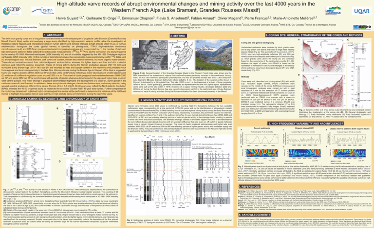
High-altitude varve records of abrupt environmental changes and mining activity over the last 4000 years in the Western French Alps (Lake Bramant, Grandes Rousses Massif) Institut des sciences de la mer de Rimouski (ISMER-UQAR), Qc, Canada; GEOTOP-UQÀM-McGiILL, Montréal, Qc, Canada; 1. ABSTRACT Two twin short gravity cores and a long piston core recovered from the deepest part of proglacial Lake Bramant (Grandes Rousses Massif, French Alps), under and overlying a large slump identified by high-resolution seismic profile, allow the investigation of Holocene natural hazards and interactions between human activity and climatic changes at high-altitude (2500 m.a.s.l.). Annual sedimentation throughout the cores (glacial varves) is identified on photographs, ITRAX (high-resolution continuous microfluorescence-X) and CAT-Scan (computerized axial tomography) analyses and is supported by (1) the number of dark and light laminations between dates obtained by radionuclide measurements (137Cs, 241Am), (2) the correlation of a slump triggered by the nearby AD 1881 Allemond earthquake (MSK intensity VII) and of a turbidite triggered by the AD 1822 Chautagne regional earthquake (MSK intensity VIII), (3) the number of laminations between two accelerator mass spectrometry (AMS) 14C dates, and (4) archaeological data. In Lake Bramant, dark layers are coarser, contain less detrital elements, but more organic matter content. These darker laminations result from calm background sedimentation, whereas the lighter layers are finer and rich in detrital elements and reflect the summer snowmelt. Traces of mining activity during the Roman civilization apogee (AD 115–330) and during the Early Bronze Age (3770–3870 cal BP) are recorded by lead and copper content in the sediments and probably result from regional and local mining activity in the NW Alps. Warmer climate during the Bronze Age in this part of the Alps is suggested by (1) two organic deposits (4160–3600 cal BP and 3300–2850 cal BP) likely reflecting a lower lake level and smaller glaciers and (2) evidence of a different vegetation cover around 2500 m a.s.l. The onset of clastic proglacial sedimentation between 3600–3300 cal BP and since 2850 cal BP is synchronous with periods of glacier advances documented in the Alps and higher lake levels in west-central Europe. This major change in proglacial sedimentation highlights the development of a larger St. Sorlin glacier in the catchment area of Lake Bramant. In addition to these abrupt climatic changes, climatic oscillations were preliminary detected using wavelet spectral analysis of different time series. Periods of 3-4, 7-8, 24-26, 30-40 years may reflect the North Atlantic Oscillation (NAO), whereas the 40-50 yrs period could be related to the so-called "Double-Hale" 45-year solar cycles. Further comparison of the multiproxy dataset with published hydro-climatological time series will be performed to determine the influence of the NAO and maybe to highlight the possible role of solar activity on high altitude alpine environments during the last 4000 years. 4. ANNUALLY LAMINATED SEDIMENTS AND CHRONOLOGY OF SHORT CORE A 3 Fabien 4 Arnaud , Olivier 5 Magand , 4 5,7 Mélières Marie-Antoinette 5 6 7Institut de la Montagne, France ETH-Zurich, Switzerland; Laboratoire EDYTEM, Université de Savoie, France; LGGE, Université Grenoble, France; INRS-ETE, Qc, Canada; ; *herve.guyard@uqar.qc.ca 3. CORING SITE, GENERAL STRATIGRAPHY OF THE CORES AND METHODS 2. SETTING C A C Coring site and general stratigraphy St. Sorlin glacier Lake Bramant Figure 1: (A) General location of the Grandes Rousses Massif in the Western French Alps. Also shown are the MSK intensities at the epicentres of regional historical earthquakes previously recorded in lake sediments. Among them, the AD 1881 Allemond earthquake (intensity MSK VII) had an epicenter located less than 12 km away from Lake Bramant. (B) Lake Bramant bathymetry (thick isobaths: 5 m). The location of the seismic profile shown in Figure 2 is indicated by a thick dotted line. This lake (2500 m.a.s.l.) is the lowermost of a chain of three proglacial lakes of the St. Sorlin glacier (C), generally considered as representative for the NW Alpine region. Hydroelectric dams were built at the lake outlet in 1918. Evidence of a copper mining industry, developed between 2300 and 2650ma.s.l. during the Early Bronze Age was recently discovered, just SE of the catchment area of Lake Bramant whereas no trace of mining activities during the Roman civilization has been discovered presently in the Massif. 5. MINING ACTIVITY AND ABRUPT ENVIRONMENTAL CHANGES Glacial varve formation since 4000 years is confirmed by counting 1220 Fe fluctuations between the two available radiocarbon ages, corresponding to a time period of 1175+/-58 years and by the identification of atmospheric metallic contaminations in the sediments (Fig. 4), likely resulting from a local and regional mining activity during the Early Bronze-Age (3770-3870 cal BP) and the Roman civilization (AD115-330), respectively. In addition, two prominent organic-rich intervals, identified on seismic profiles (Fig. 2) and in the sediment core (Fig. 4), were formed during the Bronze Age (4160–3600 and 3300–2850 cal BP) and are probably reflecting periods of reduced glacier activity in the drainage basin, resulting in periods of lower lake level and anoxic conditions. The dramatic lithologic contrast of these two organic-rich units to the remainder of the core reflects the peculiar glacial dynamics with an upstream diffluence that acts as an on–off switch of glacial meltwater supply once a certain climate threshold is reached. The onset of clastic proglacial sedimentation and higher lake level between 3600–3300 cal BP and since 2850 cal BP are reflecting periods of higher glacier activity with meltwater supply into the Bramant Valley. They are synchronous with periods of glacier advances well-documented in the Alps and high-lake levels in west-central Europe (Magny, 2004; Holzhauser et al., 2005). Undisturbed sediments were retrieved by short gravity cores and a long piston core above and below a large mass wasting deposit (MWD; Fig. 2). This slump (S) (cf. Guyard et al., 2007a, 2007b) and two high-amplitude reflectors (R1 and R2) are clearly visible in the deepest and thickest part of the basin (Fig. 2). Short gravity cores above the slump (S) are correlated based on the occurrence of the sedimentary events (E1–E3), whereas the depth of piston core BRA03 is based on the correlation of reflectors R1 and R2 with changes in the density of the sediments occurring in the organic layers OR1 and OR2, respectively (Fig. 2C). Cores were split, described and photographed (Ph) with a 400 d.p.i. resolution digital camera, before u-channels were sampled in the middle of the cores. CAT-Scan (computerized axial tomography) analyses were carried out with a pixel resolution of 1 mm for the extraction of CT number profiles (CTn). CTn primarily reflects bulk density variations (St-Onge et al., 2007). Micro-fluorescence-X (XRF) analyses were performed with an ITRAX core scanner with a downcore resolution of 300 μm for BRA03-1 and 100 μm for BRA03. BRA03-1 was irradiated during 1 s whereas BRA03 was irradiated during 10 s. The radiographs obtained (IT or RxI) were transformed in negative X-ray images. Finally, sediment grain size distribution was determined using a Beckman-Coulter LS-13320 (0.04 to 2000 μm) laser sizer with a sampling interval ranging from 0.5 to 2 cm. Fig. 2. Seismic profile (3.5 kHz) across Lake Bramant (A) and enlarged section illustrating the stratigraphy at the coring site (B). (C) General stratigraphy and lithology. (1) finely laminated clastic sediments; (2) finely laminated organic-rich sediments; (3) drop stones; (4) AMS 14C dates with a 1σ confidence limit. 6. HIGH FREQUENCY VARIABILITY AND NAO INFLUENCE? Recent sediments A 2 1 0 −1 1893 Period (yr) 1913 1933 1953 20 0 C 1893 1913 1933 1953 Analyzed Signal : CTn (5-yr smooth) 4 2 0 −2 2900 D 30 10 Organic interval OR1 C Analyzed signal: Fe (5-yr smooth) B C B Methods Original signal (normalized values) B Pierre 2,6 Francus , 2950 3000 Scale of colors from MIN to MAX 3100 70 50 30 10 2900 2950 3000 (Yr. AD) D 3050 E Clastic interval between both organic facies 3050 3100 Analyzed Signal : CTn (5-yr smooth) 2 0 −2 F Period (yr) 2 Flavio S. 3 Anselmetti , Original signal (normalized values) Emmanuel 3 Chapron , Original signal (normalized values) 1 Guillaume 1,2 St-Onge , Period (yr) Hervé Guyard1,2,*, 3300 3350 3400 3450 3500 3300 3350 3400 3450 3500 55 45 35 25 15 5 (cal. BP) Scale of colors from MIN to MAX (cal. BP) Scale of colors from MIN to MAX Fig. 5. Wavelet power spectrum of geochemical and physical time series obtained by MATLAB 7.4.0 software using the Morlet wavelet with a sampling rate of 0.1 yr. Periods of 3-4, 7-8, and 24-26 yrs are detected in recent sediments (A-B) and were previously attributed to North Atlantic Oscilations (NAO; Velasco et al., 2007). Similarly, significant periods previously attributed to the NAO are detected in organic facies (C-D; 30-40 yrs; Hurrell and Van Loon, 1997) and clastic sediments (E-F; 14-15 yrs, Hurrell and Van Loon, 1997). A significant period of about 40-50 years is also detected (C-D) and was previously related to the so-called "Double-Hale" 45-year solar cycle (Fairbridge and Hillaire Marcel, 1977). Further comparison of the multiproxy dataset with published hydro-climatological time series will be performed to better determine the influence of the NAO and maybe to highlight the possible role of solar activity on high altitude alpine environments during the last 4000 years. 137 7. REFERENCES 241 Fig. 3. (A) Cs and Am activity in core BRA03-3. Peaks in AD 1963 and AD 1986 correspond respectively to the culmination of atmospheric nuclear tests in the northern hemisphere, and to the Chernobyl (Ukraine) nuclear reactor accident. The counting of 26 couplets of dark and light-coloured laminae on digital photographs between these two dates indicate the varved nature of the sediments. This interpretation is confirmed by the correlation between slumped deposits and the strong local earthquake of AD 1881 (MSK intensity VII) (Figs. 1-2). (B) Multiproxy analysis of BRA03-1 gravity core. Exceptional flood events E2 and E3 (Guyard et al., 2007b), dated by varve counting to AD 1904-1905 and AD 1908-1910, respectively, occurred when the St. Sorlin glacier was already retreating from its last advance following the end of the “Little Ice Age” (LIA), and could be linked to climatic oscillations through the outbursts of temporary ice contact lakes or subglacial lakes during warmer periods. (C) Details of the age–depth model in the upper part of core BRA03-1. Varves were count using the CTn profile. (D) Main characteristics of dark laminations between 8 and 9.5 cm in core BRA03-1. Dark laminations have a lower CT number and Rb content, but higher Fe and Ca contents, a larger mean grain size and a higher inc/coh ratio (a proxy of organic matter content-see Fig. 4). They are interpreted as the product of calm background sedimentation, while the lighter layers, rich in detrital elements, are interpreted as resulting from the summer snowmelt. Smaller mean grain size in the lighter layer essentially reflects the deposition of the fine grained sediment suspension load, as upward lakes are acting as sediment traps for the coarser sediments transported by glacier meltwaters during the summer snowmelt. Fairbridge, R.W., Hillaire-Marcel, C., 1977. An 8000 yr paleoclimatic record of the "Double Hale" 45-yr solar cycle. Nature 268 (5619), 413-416. Guyard, H., Chapron, E, St-Onge, G., Anselmetti, F. S., Arnaud, F., Magand, O., Francus, P. & Mélières, M.A., 2007a. High-altitude varve records of abrupt environmental changes and mining activity over the last 4000 years in the Western French Alps (Lake Bramant, Grandes Rousses Massif). Quaternary Science Reviews, 26, pp.2644-2660. Guyard, H., St-Onge, G., Chapron, E., Anselmetti, F., Francus, P., 2007b. The AD 1881 Earthquake-triggered a slump and late Holocene flood-induced turbidites from proglacial lake Bramant, Western French Alps. In: V. Lykousis, D. Sakellariou and J. Locat (Eds.), Submarine Mass Movements and Their Consequences, Kluwer-Springer, pp. 279-286. Hurrell, J.W., Van Loon, H., 1997. Decadal variations in climate associated with the North AtlanticOscillation. Climatic change 36, 301-326. Holzhauzer, H., Magny, M., Zumbu¨ hl, H.J., 2005. Glacier and lake level variations in west-central Europe over the last 3500 years. The Holocene 15 (6), 789–801. Magny, M., 2004. Holocene climate variability as reflected by mid-European lake-level fluctuations and its probable impact on prehistoric human settlements. Quaternary Internationnal 113, 65–79. St-Onge, G., Mulder, T., Francus, P., Long, B., 2007. Continuous physical properties of cored marine sediments. In: Hillaire Marcel, C., de Vernal, A. (Eds.), Proxies in Late Cenozoic Paleoceanography. Elsevier, Amsterdam, pp. 63–98. Velasco., V.M., Mendoza, B., Assessing the relationship between solar activity and some large scale climatic phenomena, 2007. Advances in Space Research, in press. 8. AKNOWLEDGEMENTS Fig. 4. Multi-proxy analysis of piston core BRA03. Ph: numerical photograph; RxI: X-ray image obtained on u-channel samples by ITRAX; CT: topogram obtained by CAT-Scan; CTn: CT number; TOC: total organic carbon (%). Thanks to Michel Vallon (LGGE, Grenoble) and Marie-Christine Bailly-Maître from the Labratoire d’Archéologie Médiévale Méditerranéenne for fruitful scientific discussions. Thanks also to Urs Gerber (ETH Zürich) for the core photographs and to Bruno Axelar (Refuge de l’Étendard) for logistic support and fruitful discussions on Lake Bramant. Pierre Mandaroux and Bertrand Novel (Savoie University) are acknowledged for grain size measurements and varve counting on digital photographs of core BRA03-3, respectively. We would like to sincerely thank Atle Nesje, Oyvind Lie and all the coring team from Bergen University (Norway) for the collection of piston core BRA03 from Lake Bramant and for logistic support. This project was funded by the French Mountain Institute.


