TECHNOLOGIES FOR GEOLOGICAL AND ENVIRONMENT ... USING REMOTE SENSING DATA AND ...
advertisement

TECHNOLOGIES FOR GEOLOGICAL AND ENVIRONMENT PROTECTION PROJECTS
USING REMOTE SENSING DATA AND FIELD SPECTROMETRIC MEASUREMENTS.
Alexei V. Pertsov, Director and Svetlana G. Slutskaya, Secretary for Science
Institute of Remote Sensing Methods for Geology (VNIIKAM),
Birzhevoy proyezd 6, Saint-Petersburg, 199034, Russia
Commission VII
ABSTRACT: A review of unpublished results by Russian remote sensing institution
VNIIKAM is presented. Spectral curves in 1.2-2.4 and 8-14pm regions are obtained by
field spectrometry for crystalline rocks of Karelia and Transbaikalia. They are used
as a basic data for multispectral surveys. First radar images in the one meter region
are obtained by a new SLAH system 'IMARKt. These images provide important information
for subsurface mapping. An advance in processing of remotely sensed data is related
to tData-Knowledge Transformation' project.
KEY WORDS: Remote SenSing, Multispectral, Radar, Expert System, Image Interpretation.
INTRODUCTION
rolling) made of BaS04 and of AlzOs
ceramics. This allows to test the devices in field. Here are the results of
field spectral measurements of some
Precambrian rocks of the southern margin
of the Baltic Shield performed by
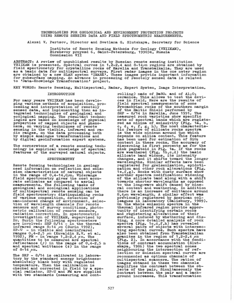
SRP - 8/14 in Karelia, June 1991. The
measured rock varieties show specific
sets of spectral bands which are registered as minima of emissivity (Fig. 1a, b,
c, d, e, f, g, h). The most characteristic feature of silicate rocks spectra
is the wide minimum around 9pm which
depends on silica content. This feature
has been used for estimation of Si02
content in these rocks. The accuracy of
discerning is first percents as for the
pink pegmatoid in Fig. 1a. If the rocks
are weathered (Fig. 1b,c,d) the basic
silicate band Widens, its intensity
changes, and it shifts toward the longer
wavelengths. Similar effects have been
registered for greisenization, epidotization and other rock alterations (Fig.
1e,f,g). Rocks with dusty surface show
another spectra modification: widening
of the silicate band along with a shift
towards shorter wavelengths as opposed
to the long-wave shift caused by mineral content and weathering. In addition
there is an increase of emittance around
8,4pm wavelength. A similar effect was
previonsly registered by American colleagues in laboratory (Salisbury, 1989).
On the whole emission spectra in the
thermal infrared region provide apportunity of identifying certain rocks
and registering alterations of their
surface, induced by whethering and distinge A more detailed analysis of rock
spectra (Fig. 1c,d,f,h) has revealed
several pairs of objects with intersecting spectral curves. Such spectra have
also been obtained from Transbaikalian
grani t es in the region of 1,2-2,4)lm
(Fig. 2). In accordance with the conditions of contrast accumulation (Slutskaya, 1986) the two spectral zones
neighbouring the intersection of reflection or emission spectral curves are
recommended as optimum channals of
multispectral scanners. The ration of
images obtaned in these two channels
amplifies the contrast between the objects of the pair. Simultaneously the
contrast between the pair and a background increases. This transformation
For many years VNIIKAM has been developing various methods of acquiSition, processing and interpretation of remotely
sensed data, and implementing them as integrated technologies of geological and
ecological mapping. The resultant technologies are based on knowledge of physical
properties of mapped objects and phenomena, on varying techniques of remote
sensing in the visible, infrared and radio ranges, on the data processing both
by Simple analogue transformations and
by digital geoinformation expert systems.
The cornerstone of a remote sensing technology is empirical knowledge of spectral
featUres of the surveyed natural objects.
SPECTROMETRY
Remote Sensing technologies in geology
need information on reflection and emission characteristics of natural objects
in the range of 0,4-14,Opm. Widerange
field spectrometry gives the most accurate estimates as compared to aerial
measurements. The following tasks of
geological and ecological applications
of multispectral remote senSing can be
field spectrometry: distinquishing rocks
of various composition, detection of
n~n-induced change of environment, selection of wavelength channels for remote
sensors and of survey conditions, photometric calibration of remote sensors,
radiation correction. In spectrometric
investigation of VNIIKAM, supervised by
Dr. Surin the following spectrometers
are involved: SRP 8/14 - in the thermal
infrared range 8-14 pm (Surin 1992),
sp-u - in visible and nearinfrared
ranges 0,4-2,5 pm (Kuvaldin E.V. et ale
1992), FM-in range 1,2-2,4pm. The
quantities to be measured are spectral
reflectance (;) in the range of 0,4-2,5 m
and spectral emittance (e) in the range
of 8-14 )lm.
The SRP - 8/14 is calibrated in laboratory by the standard energy brightnessabsolutely black body with regulated
temperature. Then the calibration is
checked and corrected in field by a special radiator. SP-U and FM are supplied
with two standards (measuring and cont-
527
c
T~
"
E09.
~
'0
....U>>
" ....,
til
....
~
w
D.~'6
~
~
--,./,.0 ,/
J-frf1,s '2..
~
.... """.. ....
lace t;
-Ferr. J{li.nat d
an..c weacll eredti 7t?ed
" J......_.... I
,.;'
@
09.
(;)
:;.,
,...
H
>
1-/
17)
~
096
~
1
w
/
1--
~
""-, J
.....
cr---~----~---+----+---~--~
,..-
It/'
t2
f,,"
V\r
sa fae 'd;
-/'el''rruqLrw.. ted
rae. et
......:;;1
~~
--"
--"
/~ ........
v-
OJ},8
\."'1..
,
' ..
\.
~
4'
-//
I'
1---
\Z.
""..
1- 10%
.)
.:2- 50%
1/
~V
0.98
I~
I-t
/'
\'-J\
092. \
09~~---9~--~10~---1~1-----R~---~~J--jl~
WAVEL£N&TH, JAM
---
-@
//
/'"
>
090
....---
/
/-
0.96
,...
,...
~
UJ
",/
'/- -/re
2.
®
....
~ 094
H
.
",'"
~/ /
8
/'
1- f're
2~ du~
h lac elj
-cy f'a ~et
/
//1
/
\(1I
9
/
10
11
/2
WAVELENt7TH, }-1M
13
4
Fig. 1. Spectral emittance of Precambrian rocks of Karelia. (a) pink pegmatoid
massif with spectrometrically estimated silica content of its different portions,
(b) amphibole-biotite schist, (c) ~ink gneiss-granite, (d) pink pegmatite,
(e) chloritized gneiss-granite, (f) pegmatoid with different content of epidote,
(g) rare-metal pink pegmatite, (h) pink gneiss-granite.
528
.P
@
1- am.azOIl.Lt.12 grQIlL ces
2.
07~------~~--~---4--------~
07
wdh. iallta tiie;
2- amazonLte qrarz.il:eS
OV(?/"ees£
w
w
(J
(J
::. 06
·-"---------l\-1b------1
~ O'6il-----\c-J~f--------.-:~--
~
~
fJJ
r1.
UI
ex
O'j~-------4----------~--~--~
y~----~-----+----~
@
1-
clLor-i.te~
ein.e;
2.- dt.."orites
maelne
O~~
1.0
with tur-m.a@
without tur-
______~~______~~--~~
1.5
2.0.iL
WAVf LE fl.1G- TH, JUM
Fig. 2. Spectral reflectance of Transbaikalian rocks.
b
a
Fig. 3. Radar pictures of an area in Turkmenistan:
(a) one meter range, (b) 4 centimeter range.
529
EXPERT SYSTEM
provides an isolation of each of these
two objects from a population of any
other objects not having intersecting
spectral curves. Thus, field spectrometry helps to select informative survey
channels and efficient algoritmous of
remote sensed data.
One of the most promiSing projects by
VNIIKAM on remote sensed data processing
is "Data-Knowledge Transformation lt (DKT)
which is headed by Dr. Naidenova. The
goal of the DKT Project is the creation
of computer tool for the integrative
interpretation of geoscience spatial data
and the recognition of such natural objects as ore deposits, rocks, vegetation
and so on combining remote sensed data,
and expert knowledge. The DKT project
encompasses the results of long-term
researches on logical classification and
pattern recognition methods. The main
idea which was an incitement to us consists in using algebraic lattice for
data representation and simulation of
classification and pattern recognition
processes. The idea that classification
is a lattice arose from practical tasks
of developing information retrieval and
pattern recognition systems. In (BoldYrev, 1974) advanced the formalization of
pattern recognition system as an algebra
with two binary operations of refinement
and generalization defined by an axiom
system including lattice axioms (Gretzer,
1982). Within this mathematical model
we have modified the traditional notion
of diagnostic test and have introduced
a new concept of the "good diagnostic
test" for a given classification (Naidenova, 1982, 1986). The problem of finding all good diagnostic tests for a
given classification and a given set of
training exemples have been first formulated and algorithms for inferring
good classification tests have been
proposed in (Naidenova, 1991; Megretskaya
1988). The unique role of the good test
concept is explained by the equivalence
of the following relationships (Naidenova, 1982; Spyratos, 1986): (a) identifying/distinguishing relation between
object descriptions, (b) functional dependency between attributes, (c) patition
dependency between classifications generated by attributes on a set of a given
objects descriptions. The decision of the
problem of finding all good classification tests allows to infer a structure
of interrelated classifications hidden
in a given set of data, to discover constraints of the three types of knowledge
(a), (b), (c) simultaneously. Implementation of the indictive mechanism for
inferring the three types of knowledge
allows to integrate data and knowledge in
one intellectual system using a uniform
management process.
RADAR
The new multi-frequency SLAR "IMARK" is
the result of a special study in the
field of remote sensing. The "IMARK" was
originally created in 1989 in the Russian
concern "VEGA". The tfI.lVIARK" reflects
four centimeter and two and an half meter ranges ot, radiowaves ; its resolution
being five and twenty five up to thirty
meters, accordingly. The system operates
with horizontal and vertical radiowave
polarizations (both linear and cross)it works at additional ranges of twenty
five centimetres and one meters (longwave ranges). tfIMARK" is capable of radiowave digital analysis, produced in
the course. or immediately after the process of surveying. The results of the
research fulfilled jointly by VNIIKAM
and the nVEGA" concern (Starostin, 1991)
can be applied to geoecological tasks.
The research resulted in the following.
Penetrating power of radiowaves of the
first meters range is increased up to
several dozens meters. The intensity of
penetration is dependent upon such factors as: composition of a bedrock; depth
of the first stratum capable of absorbing/reflecting radiowaves. The depth
level is determined by the level of
ground waters; presence or absence of
aquic faults; big deposits of electroconductive ores; patches of permafrost.
The materials supplied by the long-wave
radar survey contain important information concerning di.fferent subsurface
characteristics {especially in the regions c9vered by soft sediments. The
system is intended for ore deposits,
diamond tubes, lens, pure and mineral
waters exploration. The "IMARK'I
radar
pictures of an area in Turkmenistan
serve as an illustration (Fig. 3aand b)~
Fig. 3a shows the inner structure of
barkhans, the "roots" of wich are buried
in the Neogene relief. Comparing it to
the Fig. 3b of the same area, one can
see that in the Fig. 3a taken in the
long-wave range information about sand
ridges, interridge troughs, takyrs,
drainage system and vegetation is eliminated. As a result, mapping o~ ground
waters at depths of 30 to 50 m is possible, which is veri fied by drilling
data. Multi-frequency radar surveys of
West Siberia (the city of Surgut) discovered local patches of buried permafrost ..
The test inference algorithm mentioned
above has been implemented in SIZIF - the
System of Knowledge Acquisition from
Know Facts. SIZIF is developed in C for
IBM PC/AT or compatible computers in the
MS DOS environment. The system provides
an easy way of studying experts' data,
constructing a database and its deductive extension to a knowledge base with
the mechanisms of logical inference over
the constraints obtained from data analysis. SIZIF supports in particular the
following database models:
Thus, data obtained by the new multifrequency radar system "IMARKtt and used
jointly with conventional geologicgeographic information leads to better
geological, hydrogeological and geoecological maps and charts.
530
11. Acquisition and use of data from
thermal aerial survey to detect
hidden fires in industrial and
household waste dumps, colliery
heaps, peat deposits and other combustible rocks.
- embedding independence-reducible
scheme based on key-equivalent partition of a set of database schemes
proposed by (Ke Wang, 1990);
- canonical database scheme proposed by
N. Spyratos (Spyratos, 1986; Lecluse,
1988) •
12. Acquisition and use of thermal satellite and aerial data to detect
pollution of water reservoirs with
oil products and waste waters from
nuclear electric power plants.
SIZIF supports the majority of machine
learning problems having already been
formulated, in particular, concepts, production rules, decision trees inductive
inference by examples.
13. Acquisition and use of thermal aerial data for trouble-shooting the
ubran heating pipelines and control
of energetic losses from dwellinghouses and industrial buildings.
The universal user interface is currently being developed.
TECHNOLOGIES
14. AcqUisition and use of thermal aerial data to detect and monitor forest fires.
VNIIKAM is a research institute specializing in acquisition and use of remote
sensing data for various fields of geology and environmental studies. Specialists from VNIIKAM have developed the
following technologies:
15. Acquisition and use of data from
thermal aerial survey for monitoring
major oil and gas pipelines, to
detect leaks from irrigation systems.
1. Integrated use of remote sensing,
landscape, geologic and geophysical
data to study tectonics in oil - and
gas - bearing basins to prognosticate
oil and gas traps.
Booklets with the technologies described
are available from the authors.
REFERENCES
2. Use of remote sensing data to prognosticate reefs and other heterogeneities in sedimentary basins.
Boldyrev, N.. G., 1974. Minimization
of Boolean Partial Functions with
a Large Number of Itdon~t care"
Conditions and Feature Extraction
Problem, Discrete Systems International Symposium, Riga,USSR, September 30 - October 4~ 1974. Publishing
House "ZINATHE", Riga, USSR.
3. Use of remote srnsing data for studies of thrust tectonics in oil and
gas prospecting.
4. Acquisition, processing and use of
data from specialized aerial photographic surveys to study the geology
of sea-floor in shallow areas.
Cosmadakis, S., Kanellakis, P.C.,
Spyratos, N., 1986. Partition Semantics for Relations. J. of Computer and System Sciences, 33(2).
5. Integrated use of remote sensing.
landscape and geophysical data for
geological mapping at scales
1:200 000 and 1:50 000.
Gretzer, G., 1982. The Lattice
Theory, Moscow, Mir, (in Russian).
6" Use of remote sensing, landscape,
geological and geophysical data for
modelling major ore objects, compilation of prognostic-metallogenic
maps, and ore prospecting.
Ke Wang. 1990. Polinomial Time Designs toward both BCNF and Efficient
Data Manipulation, Proceedings of
the 1990 ACM SIGMOD International
Conference on Management of Data,
SIGMOD Record, Vol. 19, Issue 2,
pp. 74-83 ..
7. Use of remote sensing and landscape
data to prognosticate orebearing
structures in areas with alpinotype
tectonics.
Kuvaldin, E.V .. , Merkuryev, V.N .. ,
Surin, V.G., 1992t The widerange
field spectrometer 0,4-2,5 m. Soviet
journal of optical technology (in
press ).
8. Acquisition and use of data from
multifrequency radar aerial survey
for underground water prospecting.
Lecluse, C., and Spyratos, N", 1988.
Implementing Queries and Updates on
Universal Scheme Interfaoes, Proceedings of the 14 th VLDB Conference, Los Angeles, California.
9. Use of remote sensing data to compile
~ps of the enviromen state
study
~ts dynamics and predict unfavourable
changes ..
10"Use of data from thermal aerial survey to study regions of active volcanism, including submarine one.
Megretskaya, I.A., 1988. Construction of the Class~fication Natural
Tests for Knowledge Base Generation,
The Problem of the Expert System
Application in the National Economy,
531
Kishinev, (in Russian), pp.103-106.
Naidenovs, K.A., 1982. The Relational Model of Experimental Data
Analysis, Trans. of Ac. Sci. USSR,
Series "Technical Cybernetics lt ,
No.4, pp. 103-119.
Naidenovs, K.A., and Polegaeva,
J.G., 1991. SIZIF - the System of
Knowledge Acquisition from Experimental Facts, Industrial Applications of Artificial Intelligence,
Alty, J.L., and Mikulich, L.I.,
Editors, IFIP, North-Holland, Amsterdam. Proceedings of the IFIP
TC5/WG5.3 International Conference
on Artificial Intelligence in CIM,
Leningrad, USSR,16 - 18 April,
1990, pp. 87-92.
Salisbury, S.W., and Walter, L.S.,
1989, Thermal Infrared (2,5-13,5)
Spectroscopic Remote SenSing of
Igneous Rock Types on Particulate
Planetary Surfaces. Journal Geophysical Research, 94(137): 91919202.
Slutskaya, S.G., 1986, A Method of
Image Contrasts. In: Aerokosmicheskiye metody issledovaniya
selskokhozyaistvennykh ugodiy,
Gidrometeoizdat, Leningrad, USSR,
pp. 56-60. (in Russian).
Spyratos, N., 1986. The Partition
Model: A Deductive Database Model,
ACM Tra.ns .. on Database Systems,
March, pp. 62-75.
Surin, V.G., 1992. Spectral Investigation by the Field Spectrometer 8-14 m. Issledovania Zemli
iz Kosmosa, N. 2, p. 61-66 (in
Russian).
Starostin, V.A. et al., 1991. A
Technique of Subsurface Mapping.
Patent Claim, Russian copyright
of 12.12.91.
532


