AC ADEMIES NATIONAL THE
advertisement
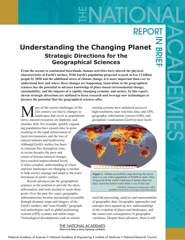
THE NATIONAL ACADEMIES Understanding the Changing Planet Strategic Directions for the Geographical Sciences IN BRIEF REPORT From the oceans to continental heartlands, human activities have altered the physical characteristics of Earth’s surface. With Earth’s population projected to peak at 8 to 12 billion people by 2050 and the additional stress of climate change, it is more important than ever to understand how and where these changes are happening. Innovation in the geographical sciences has the potential to advance knowledge of place-based environmental change, sustainability, and the impacts of a rapidly changing economy and society. In this report, eleven strategic directions are outlined to focus research and leverage new technologies to harness the potential that the geographical sciences offer. M any of the central challenges of the 21st century are tied to changes in landscapes that occur as populations move, natural resources are depleted, and climates shift. For example, quickly expanding populations have caused cities to grow, resulting in the rapid urbanization of rural environments and the loss of natural habitats and biodiversity. Although Earth’s surface has been in constant flux throughout time, in recent decades the pace and extent of human-induced changes have reached unprecedented levels. A more complete understanding of where and how landscapes are changing is needed to help society manage and adapt to the transformation of earth’s surface. Recent advances put the geographical sciences in the position to provide the ideas, information, and tools needed to reach these goals. Over the past few years, geographic information has become increasingly accessible through dynamic maps and imagery of the Earth’s surface, and “user-friendly” geographical technologies such as global positioning systems (GPS) systems and online maps. Technological developments such as remote sensing systems have enhanced access to high-resolution, near real-time data, and GPS, geographic information systems (GIS), and geospatial visualization (GeoViz) have facili- 0 1 2 3 4 6 8 12 18 24 36 2d 3d 4d 5d 10d Travel time to major cities (in hours and days) and shipping lane density Figure 1. Global accessibility map showing the travel time to a city with a population of 50,000 or more. Only 10 percent of the world’s land area is farther than two days’ travel by land or water from a city of this size. SOURCE: European Commission, 2008. Available at bioval.jrc.ec.europa.eu/products/gam tated the processing, analysis and representation of geographic data. Geographic approaches and concepts have opened up new understandings of the evolution of places and landscapes, and the causes and consequences of geographic variations. Despite these advances, there is still National Academy of Sciences • National Academy of Engineering • Institute of Medicine • National Research Council 5–10 years, and can be investigated using methods and sources of data that either currently exist or are expected to be readily available in the next few years. The eleven strategic directions are grouped by topic area, but are not ranked in any order of importance. How to understand and respond to environmental change 1. How are we changing the physical environment of Earth’s surface? 2. How can we best preserve biological diversity and protect endangered ecosystems? Figure 2. Three-dimensional geographical visualizations (GeoViz) show the difference in water flow between a river with no dams (top) and a dammed river where the natural water flow is significantly modified (bottom). Three dimension diagrams of this sort make it easier to visualize how humans impact the river environment. SOURCE: Strandhagen et al., 2006. much to be done to understand the changes that face Earth in the 21st century. At the request of the National Science Foundation, the U.S. Geological Survey, the National Geographic Society, and the Association of American Geographers, the National Academies established a committee to identify research initiatives that take advantage of recent technological advancements, inspire continued innovation in the geographical sciences, and advance understanding of the major issues facing Earth. Eleven Strategic Directions This report outlines eleven strategic directions for research in the geographical sciences. These goals have a strong likelihood of achieving significant and demonstrable results in the next 3. How are climate and other environmental changes affecting human interactions with ecosystems? Research has documented shifts in climate, soil erosion, habitat loss, and water degradation, but the human role in these changes is often inadequately understood, hindering abilities to predict the magnitude and timing of future change. Using data extracted from tree-rings and fossilized pollen, for example, geographical scientists can develop reconstructions of long-term environmental history and map these changes across the landscape. Technologies such as remote sensing and geographical visualization can help scientists determine the role of physical and human influences in causing changes in the physical environment. How to promote sustainability 4. How and where will 10 billion people live on Earth? 5. How will we sustainably feed everyone in the coming decade and beyond? 6. How does where people live affect their health? Earth’s population is projected to peak at 8 to 12 billion people by 2050, with most population growth in urban areas. Many cities will struggle to accommodate rapidly increasing populations, and the conversion of rural land to urban areas could alter biogeochemical cycles, hydrological systems, climate, wildlife habitat and biodiversity. Increasing populations will require more food, and the critical challenge of feeding the world’s expanding population will depend on an accurate assessment of population distribution, and on knowledge of changing agricultural production and distribution systems. Access to healthcare will also be stretched by an expanding population, and standards in the treatment and prevention of illness will vary according to location. Using spatial analysis, GIS, and models of disease spread, research in the geographical sciences can advance understanding of how migration, environmental conditions, economics, and public policy influence health and the spread of infectious diseases. Analysis of disease and health-care patterns is fundamental to understanding both disease behavior and the varying vulnerabilities of different populations; this information will be fundamental in developing policies that promote greater human well-being worldwide. How to recognize and cope with the rapid spatial reorganization of economy and society 7. How is the movement of people, goods and ideas changing the world? 8. How is economic globalization affecting inequality? 9. How are geopolitical shifts influencing peace and stability? From human migration to the movement of freight, global mobility has increased rapidly over the past 40 years, affecting transportation, communication, the economy, and even patterns of political conflict. Research in the geographical sciences—utilizing a wide variety of tools from individual interviews and census data to largescale studies using GIS and remote sensing— can shed light on the consequences of increasing mobility, and the implications of mobility for matters ranging from economic development to political stability. How to leverage technological change for the betterment of society and environment 10. How might we better observe, analyze and visualize a changing world? 11. What are the societal implications of citizen mapping and mapping citizens? Since ancient times, observation, mapping, and representation of Earth’s surface have been integral to geographical research, and remain central to the modern geographical sciences today. Websites that provide geographical information have become a critical part of daily life, empowering citizens as both the sources and subjects of mapping—but the explosion geographical information has led to concerns about individual privacy and how to properly evaluate the quality of volunteered map information. Recent advances in geographical tools and technologies to observe, analyze, and visualize the changes shaping the human and physical features on Earth’s surface will be critical to answering basic scientific questions and defining the best policies to address the challenges facing Earth in the decades ahead. New GIS Techniques Allow New Insight New techniques allow geographical data to be displayed simultaneously in many different ways, leading to new insights. Here, a screenshot from the geographic information system (GIS) software package GeoDa shows data on the rate of Sudden Infant Death Syndrome by North Carolina county. Four perspectives are shown: map (upper left; darkest colors depict the highest rates), table (lower left), histogram (lower right); and in the upper right, a scatter plot of each county’s rate against the average of its neighbors, a plot that allows the easy identification of counties with anomalous rates that stand out from their neighbors. GeoDa was developed for the exploration and analysis of geographical data by the GeoDa Center at Arizona State University. SOURCE: GeoDa 0.9 (Beta). To download go to http://geodacenter.asu.edu/ Figure 3. This map of urban growth in Doha, Qatar, from 1973-2007 illustrates the trend of increasing urbanization occurring in mid-sized cities around the world. SOURCE: Karen Seto, used with permission. Moving Forward The eleven research questions outlined above illustrate the great potential of the geographical sciences to address the fundamental challenges facing science and society in the early 21st century. Given the extent and magnitude of the geographical transformations currently unfolding, it will be imperative to understand why changes happen in particular places. Although rapid progress has been made in geographical research in recent years, moving forward will require work to expand the scope of geographical research. In these efforts, the geographical science community has an opportunity to enhance key support systems to mobilize research infrastructure, training and outreach efforts to focus progress towards these goals. For example, most progress in the geographical sciences to date has been the result of independent research initiatives, but large-scale collaborations between researchers with diverse areas of expertise is needed to address many of the challenges facing Earth in the 21st century. Training the next generation of geographical scientists will require an updated curriculum to promote geographic understanding, spatial thinking, and geographical research skills and to teach students how to make use of recent technological advances. Outreach is needed to inform policy makers, administrators, media figures and others of the potential offered by the geographical sciences, and to foster links between the geographical science community and the general public. The committee envisions that the research priorities outlined in this report will lay out the path to an increasingly sophisticated, well-organized and powerful geographical science, which will serve as a foundation for a broad spectrum of scientific research, inform policy decisions and enable citizens to understand and critique the geographical technologies that play an increasingly important role in everyday life. Committee on Strategic Directions for the Geographical Sciences: Alexander B. Murphy (Chair), University of Oregon, Eugene; Nancy Colleton, Institute for Global Environmental Studies; Roger M. Downs, Pennsylvania State University, University Park; Michael F. Goodchild, University of California, Santa Barbara; Susan Hanson, Clark University, Worcester, Massachusetts; Victoria Lawson, University of Washington, Seattle; Glen MacDonald, University of California, Los Angeles; Francis J. Magilligan, Dartmouth College; William G. Moseley, Macalester College; Colin Polsky, Clark University; Karen C. Seto, Yale University, New Haven; Dawn J. Wright, Oregon State University, Corvallis; Mark D. Lange (Study Director), Jason R. Ortego (Research Associate), Tonya Fong Yee (Senior Program Assistant), National Research Council. The National Academies appointed the above committee of experts to address the specific task requested by the National Science Foundation. The members volunteered their time for this activity; their report is peer-reviewed and the final product signed off by both the committee members and the National Academies. This report brief was prepared by the National Research Council based on the committee’s report. For more information, contact the Board on Earth Sciences and Resources at (202) 334-2744 or visit http://nationalacademies.org/ besr. Copies of Understanding the Changing Planet: Strategic Directions for the Geographical Sciences are available from the National Academies Press, 500 Fifth Street, NW, Washington, D.C. 20001; (800) 624-6242; www.nap.edu. Permission granted to reproduce this brief in its entirety with no additions or alterations. Permission for images/figures must be obtained from their original source. © 2010 The National Academy of Sciences
