Determining the flow fields of two glacier outlets of the... Norway, using digital photogrammetry
advertisement
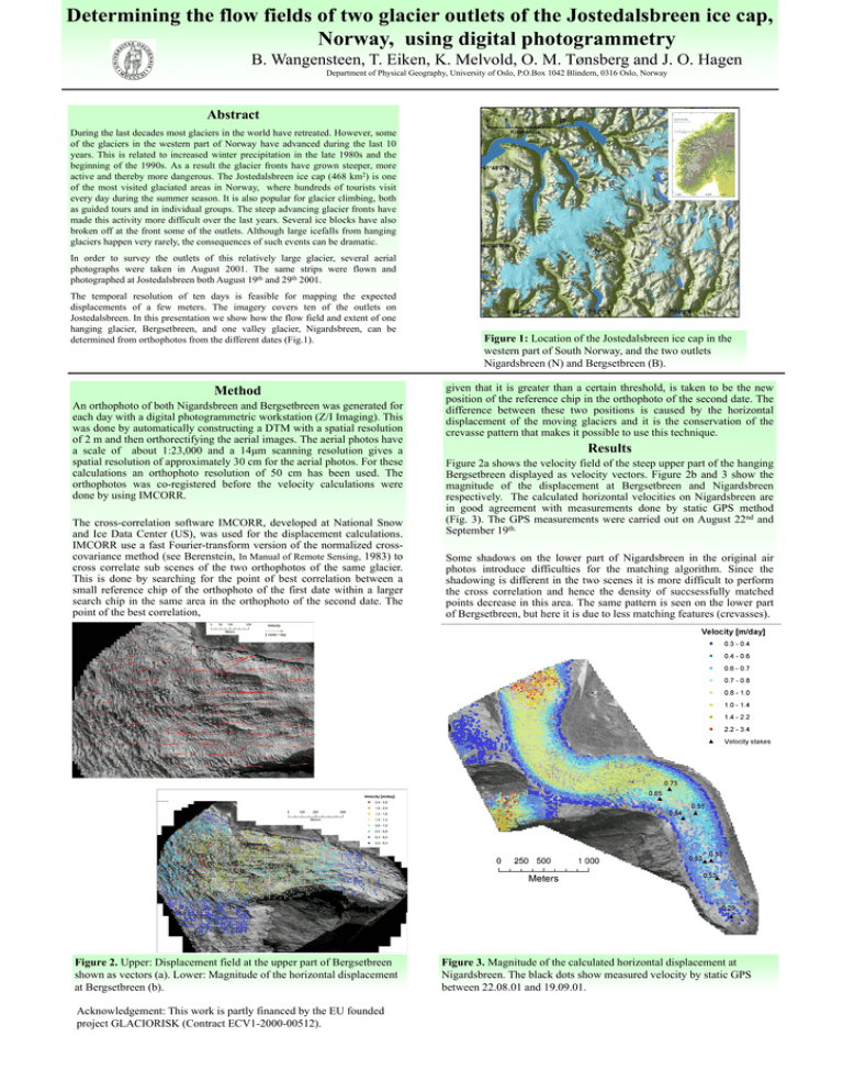
Determining the flow fields of two glacier outlets of the Jostedalsbreen ice cap, Norway, using digital photogrammetry B. Wangensteen, T. Eiken, K. Melvold, O. M. Tønsberg and J. O. Hagen Department of Physical Geography, University of Oslo, P.O.Box 1042 Blindern, 0316 Oslo, Norway Abstract During the last decades most glaciers in the world have retreated. However, some of the glaciers in the western part of Norway have advanced during the last 10 years. This is related to increased winter precipitation in the late 1980s and the beginning of the 1990s. As a result the glacier fronts have grown steeper, more active and thereby more dangerous. The Jostedalsbreen ice cap (468 km2) is one of the most visited glaciated areas in Norway, where hundreds of tourists visit every day during the summer season. It is also popular for glacier climbing, both as guided tours and in individual groups. The steep advancing glacier fronts have made this activity more difficult over the last years. Several ice blocks have also broken off at the front some of the outlets. Although large icefalls from hanging glaciers happen very rarely, the consequences of such events can be dramatic. In order to survey the outlets of this relatively large glacier, several aerial photographs were taken in August 2001. The same strips were flown and photographed at Jostedalsbreen both August 19th and 29th 2001. The temporal resolution of ten days is feasible for mapping the expected displacements of a few meters. The imagery covers ten of the outlets on Jostedalsbreen. In this presentation we show how the flow field and extent of one hanging glacier, Bergsetbreen, and one valley glacier, Nigardsbreen, can be determined from orthophotos from the different dates (Fig.1). Method An orthophoto of both Nigardsbreen and Bergsetbreen was generated for each day with a digital photogrammetric workstation (Z/I Imaging). This was done by automatically constructing a DTM with a spatial resolution of 2 m and then orthorectifying the aerial images. The aerial photos have a scale of about 1:23,000 and a 14μm scanning resolution gives a spatial resolution of approximately 30 cm for the aerial photos. For these calculations an orthophoto resolution of 50 cm has been used. The orthophotos was co-registered before the velocity calculations were done by using IMCORR. The cross-correlation software IMCORR, developed at National Snow and Ice Data Center (US), was used for the displacement calculations. IMCORR use a fast Fourier-transform version of the normalized crosscovariance method (see Berenstein, In Manual of Remote Sensing, 1983) to cross correlate sub scenes of the two orthophotos of the same glacier. This is done by searching for the point of best correlation between a small reference chip of the orthophoto of the first date within a larger search chip in the same area in the orthophoto of the second date. The point of the best correlation, Figure 2. Upper: Displacement field at the upper part of Bergsetbreen shown as vectors (a). Lower: Magnitude of the horizontal displacement at Bergsetbreen (b). Acknowledgement: This work is partly financed by the EU founded project GLACIORISK (Contract ECV1-2000-00512). N B Figure 1: Location of the Jostedalsbreen ice cap in the western part of South Norway, and the two outlets Nigardsbreen (N) and Bergsetbreen (B). given that it is greater than a certain threshold, is taken to be the new position of the reference chip in the orthophoto of the second date. The difference between these two positions is caused by the horizontal displacement of the moving glaciers and it is the conservation of the crevasse pattern that makes it possible to use this technique. Results Figure 2a shows the velocity field of the steep upper part of the hanging Bergsetbreen displayed as velocity vectors. Figure 2b and 3 show the magnitude of the displacement at Bergsetbreen and Nigardsbreen respectively. The calculated horizontal velocities on Nigardsbreen are in good agreement with measurements done by static GPS method (Fig. 3). The GPS measurements were carried out on August 22nd and September 19th. Some shadows on the lower part of Nigardsbreen in the original air photos introduce difficulties for the matching algorithm. Since the shadowing is different in the two scenes it is more difficult to perform the cross correlation and hence the density of succsessfully matched points decrease in this area. The same pattern is seen on the lower part of Bergsetbreen, but here it is due to less matching features (crevasses). Figure 3. Magnitude of the calculated horizontal displacement at Nigardsbreen. The black dots show measured velocity by static GPS between 22.08.01 and 19.09.01.


![[PS3-B.92] Deriving glacier flow of Comfortlessbreen, Svalbard, with 2-pass differential SAR interferometry](http://s2.studylib.net/store/data/011437273_1-88e0d14685f316dfdf96d3e475d13e45-300x300.png)
